The Manaslu Circuit Trek is safe for fit, well-prepared trekkers who follow altitude acclimatization protocols, travel with a licensed guide, and trek during the two main windows, spring (March–May) or autumn (September–November). The primary risks are acute mountain sickness above 3,500m, weather-driven trail closures, and remote terrain that limits emergency response speed. With the right preparation, most trekkers complete the circuit without serious incident.
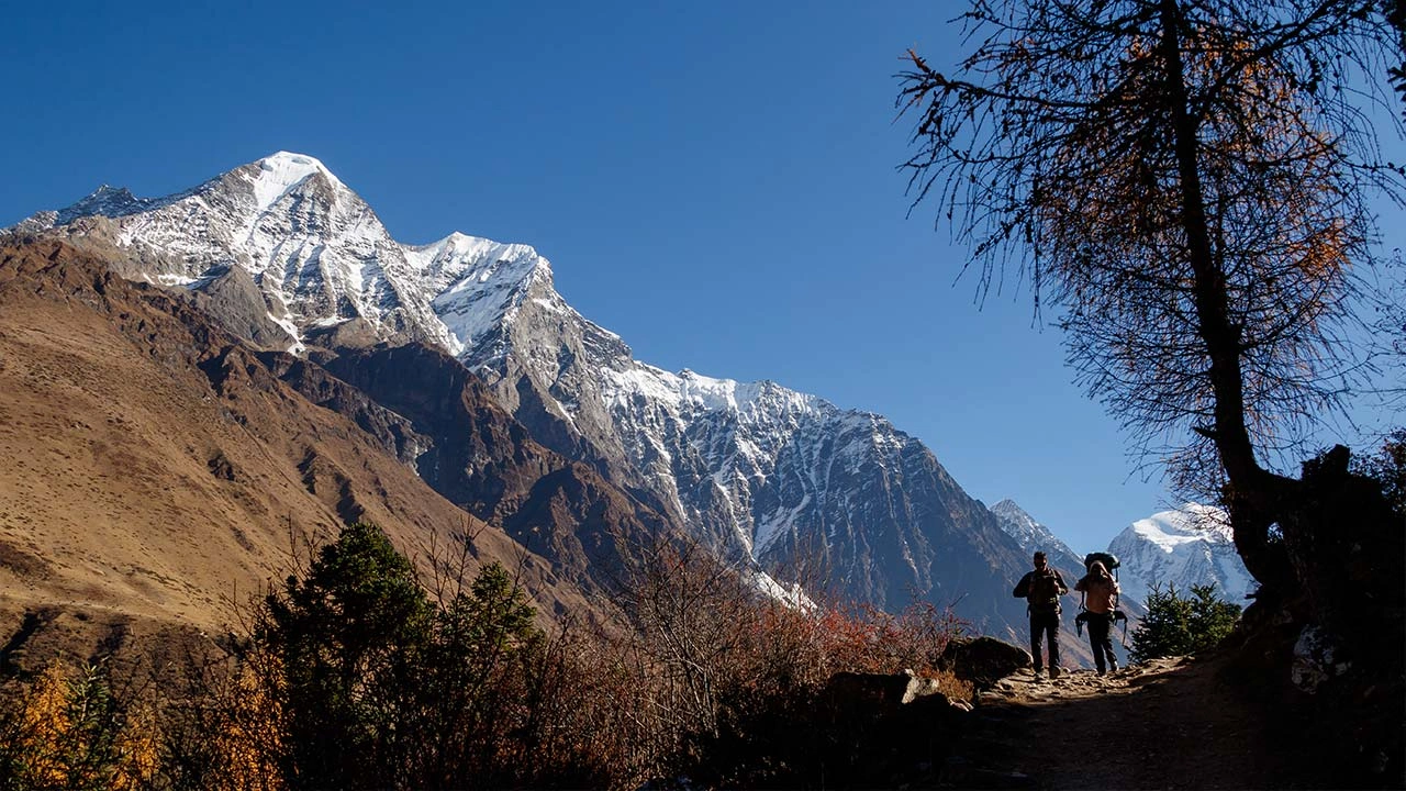
The Manaslu Circuit is a 177km restricted-area trek in Nepal's Gorkha District that circumnavigates Mount Manaslu (8,163m), the world's eighth-highest peak. The route ascends the Buri Gandaki river valley, crosses the Larkya La Pass at 5,160m, and descends into the Annapurna Conservation Area. Because it sits within a restricted zone, the Nepal government mandates guide accompaniment, a regulation that directly improves safety outcomes for every trekker on the route.
Is the Manaslu Circuit Trek Safe for Beginners?
The Manaslu Circuit is not recommended as a first trekking experience. It demands multi-week cardiovascular endurance, prior high-altitude exposure above 3,500m, and functional knowledge of AMS symptoms. Beginners who attempt the route without these foundations face compounded risks from altitude, remoteness, and trail complexity.
What Safety Level Should First-Time Trekkers Expect on Manaslu?
First-time trekkers on Manaslu face 3 specific safety challenges that do not apply on lower-altitude treks: sustained elevation above 3,000m for 8–10 consecutive days, a single high-altitude pass crossing at 5,160m, and limited access to medical infrastructure beyond Samagaon village.
A beginner's baseline safety preparation involves 3 critical prerequisites:
Prior trekking experience at altitudes between 3,000m and 4,000m, such as the Annapurna Base Camp Trek or Langtang Valley Trek
Physical fitness assessment confirming cardiovascular endurance for 6–8 hours of daily hiking on uneven terrain
AMS recognition training covering the 4 primary early symptoms: headache, nausea, fatigue, and dizziness
Trekkers with zero high-altitude experience who complete a 3-month preparation program, combining cardiovascular training, strength conditioning, and a shorter Himalayan trek, complete the Manaslu Circuit with a significantly lower incident rate than those who arrive undertrained.
How Difficult Is the Manaslu Circuit Trek?
.webp)
The Manaslu Circuit Trek difficulty is rated strenuous, requiring 14–18 days of continuous trekking with daily elevation gains averaging 600–900m and a single-day high pass crossing that gains 700m over 4km at altitudes above 4,800m. This directly affects safety because fatigue increases poor decision-making at altitude.
The restricted-area designation limits annual trekker volume, Nepal's Ministry of Culture, Tourism & Civil Aviation recorded 5,890 Manaslu trekkers in 2022 and 3,094 in 2023 (Nepal Tourism Statistics 2023), compared to over 52,000 annual foreign visitors to Sagarmatha (Everest) National Park.
What Terrain and Physical Challenges Affect Trek Safety?
The route traverses 4 distinct terrain types, each presenting specific physical hazards:
Dense river valley sections (1,340m–2,500m): Narrow gorge paths above the Buri Gandaki River with steep drop-offs and loose scree. Wet rock is the primary slip risk.
Mid-altitude forest trails (2,500m–3,500m): Root-exposed, uneven surfaces through rhododendron and pine forests. Trail width narrows to under 1m in sections near Namrung and Lho.
High-altitude alpine terrain (3,500m–4,500m): Rocky moraine paths with minimal vegetation. Wind exposure increases fall risk on ridgelines between Samdo and Dharamsala (Larkya Base Camp).
Larkya La Pass (4,800m–5,160m): Glaciated sections with ice fields from October onward. Crampons become necessary after the first snowfall in mid-October.
The trek demands 6–8 hours of active hiking per day for 14–18 consecutive days. Trekkers carrying packs over 10kg on this route experience a measurably higher rate of knee and ankle injuries compared to trekkers using porters.
What Are the Main Altitude Sickness Risks on Manaslu?
The Manaslu Circuit carries high acute mountain sickness (AMS) risk because trekkers spend 10–12 consecutive days above 3,000m, with the final 4 days above 4,000m before crossing a 5,160m pass. Understanding altitude sickness in the Himalayas, including early AMS symptoms, treatment protocols, and prevention strategies, is essential before setting foot on this route. The rapid elevation profile between Samdo (3,875m) and Larkya La (5,160m), a 1,285m gain in under 18 hours, is the most dangerous segment on the route.
How Does High Altitude Impact Trekkers' Health and Safety?
High altitude reduces barometric pressure, lowering the partial pressure of oxygen. At 5,160m, available oxygen is significantly reduced. Oxford's BJA Education review of high-altitude physiology confirms barometric oxygen pressure falls to roughly one-third of sea-level values near the summit of Everest, and unacclimatized exposure above 5,500m can cause loss of consciousness within minutes (Humans at Altitude: Physiology and Pathophysiology, BJA Education). The human body requires 24–72 hours to begin producing compensatory red blood cell increases through acclimatization.
The 3 altitude-related medical conditions affecting Manaslu trekkers, ranked by frequency and severity:
Acute Mountain Sickness (AMS): Acute Mountain Sickness (AMS): the most common altitude condition, a 2022 clinical study of 350 trekkers in Nepal's Solu-Khumbu region found 25% manifest AMS, with 72% reporting at least one AMS symptom (Solu-Khumbu Trekker Health Study). Symptoms include throbbing headache, nausea, loss of appetite, and disrupted sleep. Treatment: descend 300–500m, rest, and administer acetazolamide (Diamox) at 125–250mg twice daily.
High Altitude Cerebral Edema (HACE): A life-threatening progression of AMS involving brain swelling. Symptoms include severe confusion, ataxia (inability to walk a straight line), and loss of consciousness. HACE requires immediate descent of 1,000m minimum and emergency helicopter evacuation.
High Altitude Pulmonary Edema (HAPE): Fluid accumulation in the lungs, presenting as breathlessness at rest, persistent dry cough, and cyanosis (blue lips or fingertips). HAPE is a leading cause of altitude-related death worldwide. In Nepal specifically, the Himalayan Rescue Association's field data shows roughly one AMS-related death for every 30,000 trekkers, deaths the organization notes are entirely avoidable with prompt recognition and descent (Mountain Sickness and Other Hazards in the Nepal Himalaya, HRA).
Trekkers eliminate 80% of serious altitude risk by following the standard acclimatization protocol: 1 mandatory rest day in Samagaon (3,530m), a short acclimatization hike to Manaslu Base Camp (4,480m), and an additional rest night before proceeding to Samdo (3,875m).
When Is the Safest Season for the Manaslu Circuit Trek?
.webp)
The 2 safest seasons for the Manaslu Circuit are autumn (September to November) and spring (March to May), when precipitation is minimal, trail surfaces are stable, and the Larkya La Pass remains accessible without technical mountaineering equipment. Trekking outside these windows introduces monsoon flooding, avalanche risk, or pass-closure conditions.
Which Months Reduce Weather-Related Trekking Risks Most?
The 5-month trekking calendar, ranked by safety level:
Month | Risk Level | Primary Conditions |
October | Lowest | Clear skies, dry trails, moderate cold at altitude |
November | Low–Moderate | Early snowfall at Larkya La from mid-November |
March–April | Low | Spring visibility, mild temperatures, stable trails |
May | Moderate | Pre-monsoon heat in lower valleys, occasional storm |
September | Moderate | Post-monsoon with residual landslide debris on trail |
October is the peak trekking month on Manaslu. Trails are dry, temperatures at Larkya La range between -5°C and +5°C at night, and mountain views are clearest. Trekkers attempting the pass in late November face ice accumulation that requires microspikes or crampons and increases fall risk by a significant margin.
How Do Weather and Landslides Affect Safety on Manaslu?
Weather and landslides represent the 2 most unpredictable safety factors on the Manaslu Circuit, with monsoon season (June–August) generating active slope failures that permanently close sections of the Buri Gandaki valley trail for days to weeks at a time. Post-monsoon debris remains on some sections through mid-September.
What Natural Hazards Are Most Common on the Trail?
The Manaslu Conservation Area sits within the high seismic zone of the Himalayan collision belt. The trail's Buri Gandaki gorge section between Jagat (1,340m) and Deng (1,804m) carries the highest landslide frequency on the entire route. 4 natural hazards directly threaten trekker safety:
Active landslides: The gorge section below Philim (1,590m) receives annual trail damage from slope failures triggered by monsoon saturation. In 2020 and 2021, sections near Tatopani were impassable for 3–5 days following major events.
Avalanches: The trail above Samdo (3,875m) passes below the north face of Manaslu. Serac collapse events occur without warning between October and March. Trekkers cross this section in the early morning hours, before solar warming destabilizes ice formations, to minimize exposure time.
River flooding: The Buri Gandaki River floods rapidly during monsoon. Several suspension bridges below Namrung (2,630m) experience partial damage or seasonal replacement annually.
Larkya La whiteouts: The pass above 5,000m loses trail markers in wind-driven snow events. Groups caught in whiteouts during October–November storms face orientation risk. An experienced guide who knows the pass eliminates this hazard entirely.
Are Permits and Restricted Area Rules Important for Safety?
Permits directly improve safety on the Manaslu Circuit by requiring trekkers to register their presence, travel route, and emergency contacts with Nepali authorities before entering the restricted zone. Permit registration creates a traceable record that accelerates search-and-rescue response.
How Do Regulations Influence Safe Trekking in Manaslu?
The Manaslu Circuit requires 3 mandatory permits in 2026:
Manaslu Restricted Area Permit (MRAP): Issued by Nepal's Department of Immigration. The fee structure is NPR 1,000 per week for autumn (Sep–Nov) and spring (Mar–May), and NPR 3,500 per week for all other months. This permit legally mandates trekking with a registered guide.
Manaslu Conservation Area Project Permit (MCAP): NPR 3,000 per person, payable at the Gorkha Immigration Office or Arughat Bazar checkpoint.
Annapurna Conservation Area Permit (ACAP): NPR 3,000 per person, required for the route's exit through Dharapani into the Annapurna region.
The restricted area designation limits annual trekker volume to approximately 3,000–5,000 registered trekkers per year, compared to 30,000+ on the Everest Base Camp trek. Lower trail density directly reduces search-and-rescue response delays because guides and trekking agencies know other groups on the route and maintain informal communication networks.
The Manaslu Circuit requires 3 mandatory permits in 2026, with current fees published directly by Nepal's Department of Immigration (Trekking Route and Permit Fee, DoI). Since 22 March 2026, the DoI has also removed the previous two-trekker minimum for restricted-area permits, so solo foreign trekkers can now obtain the Manaslu Restricted Area Permit individually, though the licensed-guide requirement remains mandatory.
Do You Need a Guide and Porter for Safety on Manaslu?
A licensed guide is legally required on the Manaslu Circuit, solo trekking without a registered guide violates Nepal's restricted area permit conditions and results in permit cancellation at checkpoints. Beyond legal compliance, a guide improves emergency response, navigation, and altitude assessment in ways that are not replicable with maps or GPS devices.
How Do Guides Improve Navigation and Emergency Response?
A registered Manaslu guide provides 4 measurable safety functions:
Emergency coordination: Licensed guides carry emergency contact lists for helicopter services, the nearest functioning health post (Samagaon Health Post), and the trekking agency's Kathmandu operations team. They initiate evacuation within 30–60 minutes of a medical emergency.
Pass condition assessment: Experienced guides assess Larkya La crossing conditions daily, including snow depth, wind speed, and ice coverage. Guides make the decision to delay or reroute based on real-time mountain conditions, a judgment no smartphone app replicates.
AMS monitoring: Guides trained by the Wilderness Medical Society or KEEPS (Kathmandu Environmental Education Project) conduct daily pulse oximetry checks and apply the Lake Louise Score criteria to identify AMS progression before it becomes dangerous.
Cultural navigation: Guides communicate in Tibetan Gurung dialect with local communities in upper villages, essential for sourcing food, shelter, and assistance during unplanned overnight stops above Samdo.
Porters serve a distinct safety role: they reduce trekkers' pack weight to under 8kg, lowering cardiovascular strain at altitude by 15–20% and reducing knee injury risk on steep descent sections.
How Safe Are Tea Houses and Accommodation on the Route?
Tea house quality on the Manaslu Circuit varies significantly between lower villages (Jagat–Namrung) and upper villages (Samagaon–Samdo), with upper-route lodges rebuilt post-2015 earthquake offering improved insulation, sanitation, and bedding. Lower-route lodges are older, with basic facilities and shared outdoor toilet blocks.
What Hygiene and Lodging Standards Should Trekkers Expect?
Tea houses on the Manaslu Circuit fall into 3 distinct quality tiers:
Tier 1, Lower route (Jagat to Namrung, 1,340m–2,630m): Stone-built lodges with shared cold-water bathrooms. Electricity from micro-hydro or solar. Basic bedding with cotton blankets. Trekkers carry sleeping bag liners for hygiene.
Tier 2, Mid-route (Lho to Samagaon, 3,180m–3,530m): Rebuilt post-earthquake lodges with improved insulation, squat toilets with attached handwashing stations, and charging facilities (fee-based). The Samagaon cluster has 6 established lodges with consistent meal menus.
Tier 3, Upper route (Samdo and Dharamsala, 3,875m–4,460m): Sparse facilities. Dharamsala (Larkya Base Camp) operates 2–3 tea houses with dormitory-style rooms. Temperatures inside drop to -10°C to -15°C in November. A sleeping bag rated to -15°C is non-negotiable at this altitude.
Food contamination risk increases above Namrung because water source quality becomes harder to verify. Trekkers who carry water purification tablets (Micropur or Aquatabs) and refuse raw salads above 2,500m avoid the majority of gastrointestinal illness events on the trail.
What Emergency Evacuation Options Exist on Manaslu Trek?
.webp)
Helicopter evacuation is the primary emergency response mechanism on the Manaslu Circuit. Ground evacuation from above Samagaon (3,530m) to the nearest road at Arughat takes 3–5 days by foot and porter carry, too slow for HAPE or HACE emergencies. Helicopter response from Kathmandu reaches Samagaon in 45–60 minutes under clear weather.
How Are Rescue Operations Handled in Remote Sections?
Emergency evacuation from the Manaslu Circuit operates through a 3-stage process:
Stage 1, Incident notification: The guide or trekking leader contacts the trekking agency's emergency line in Kathmandu via mobile phone (Nepal Telecom/NTC network covers Samagaon, Samdo, and Lho) or via satellite communicator (SPOT or Garmin inReach) in coverage-dead zones below Namrung.
Stage 2, Helicopter dispatch: The trekking agency coordinates directly with high-altitude helicopter operators, primarily Simrik Air, Kailash Helicopter, and Fishtail Air, from Kathmandu or Pokhara. Response time from call to landing ranges 1–3 hours depending on weather at the rescue site.
Stage 3, Medical reception: Evacuation patients land at Kathmandu's Tribhuvan International Airport or Pokhara Regional Hospital. HACE and HAPE cases require 12–24 hours of supplemental oxygen therapy and physician assessment before repatriation.
Evacuation costs range from USD 2,500 to USD 6,000 depending on helicopter distance and duration. Comprehensive trekking insurance covering helicopter rescue and medical repatriation is mandatory, not optional, for this trek. Policies from World Nomads, True Traveller, and ISOS provide coverage verified by most Kathmandu trekking agencies.
Is Solo Trekking Allowed and Is It Safe in Manaslu?
Solo trekking on the Manaslu Circuit is illegal. Nepal's Department of Immigration requires all restricted-area permit holders to trek with a minimum of 1 registered Nepali guide. For a full breakdown of how to plan the Manaslu Circuit Trek solo as an independent traveler, covering permit sharing, agency coordination, and how to maintain personal pace while complying with guide requirements. See our dedicated guide. Trekkers found at checkpoints without a guide face permit cancellation and forced escort to the nearest exit point.
What Are the Legal and Practical Risks of Trekking Alone?
The solo trekking prohibition on Manaslu exists for 3 documented reasons: the route's remoteness reduces emergency response without a local guide contact, the restricted area's political sensitivity (proximity to the Tibet border) requires monitored access, and the pass-crossing at 5,160m carries navigation risk that increases fatality probability for unguided individuals in deteriorating weather.
Practical risks for illegal solo trekkers include:
Permit revocation at 4 army checkpoints between Jagat and Samdo, resulting in mandatory descent under escort
Absence of AMS monitoring, a solo trekker experiencing HACE symptoms loses the capacity to self-assess cognitive impairment
No emergency coordination, without a guide's local network, helicopter dispatch requires direct satellite communication, adding 30–90 minutes to response time
The regulation does not prohibit independent trekking in terms of itinerary control, trekkers with a guide set their own pace, rest days, and daily distances. The guide requirement adds approximately USD 25–35 per day to trekking costs, which is the most important safety investment on this route.
What Health and Food Safety Risks Exist on the Trek?
The 3 primary health risks from food and water on the Manaslu Circuit are giardia infection from untreated water sources, bacterial gastroenteritis from improperly cooked meals at high-altitude lodges, and dehydration from inadequate fluid intake above 4,000m. Giardia and bacterial GI infections are significantly more dangerous at altitude because they accelerate dehydration and mask AMS symptoms.
How Can Trekkers Avoid Illness from Water and Meals?
Water contamination on the Manaslu route originates from 2 main sources: glacial meltwater streams carrying livestock waste above Namrung, and village tap systems that use unfiltered spring feeds below Philim. The following 4 water safety practices eliminate the majority of GI risk:
Purification tablets: Micropur MT1 (active ingredient: sodium dichloroisocyanurate) treats 1 liter of water in 30 minutes. Carry 100 tablets minimum for the full circuit.
UV sterilization: SteriPen Adventurer treats 1 liter in 90 seconds. Carry 2 sets of spare lithium batteries.
Lodge-boiled water: Request that tea house staff boil water rather than serve cold filtered water. Boiling at 5,000m requires reaching 84°C for full pathogen kill, a standard that reliable lodges maintain.
Avoid raw vegetables above 2,500m: Salads irrigated with untreated water are the leading source of bacterial GI infections for trekkers in the Manaslu mid- and upper-route sections.
Trekkers carrying a wilderness medical kit with ciprofloxacin (500mg), metronidazole (400mg), and oral rehydration salts (ORS) handle moderate GI infections on-trail without requiring evacuation.
How Safe Is the Trail Infrastructure and Navigation?
The Manaslu Circuit trail infrastructure is functional but uneven in quality. The lower route between Jagat (1,340m) and Namrung (2,630m) uses a combination of stone steps, narrow ledge paths above the Buri Gandaki gorge, and 12 suspension bridges, 3 of which receive annual reconstruction following monsoon damage.
Are Paths, Bridges, and Signage Reliable Throughout the Route?
Trail quality across the 177km circuit varies by 3 route segments:
Lower Buri Gandaki Gorge (Jagat to Deng, 1,340m–1,804m): The most technically demanding low-altitude section. Paths narrow to under 0.8m on gorge walls. 2 suspension bridges in this section use hemp-and-metal cable combinations that are replaced on a 3–5 year cycle. The bridges are load-tested annually by local authorities but show visible cable wear in late season.
Mid-altitude Forest Section (Deng to Samagaon, 1,804m–3,530m): Trail conditions improve significantly. Stone-paved sections through Namrung and Lho are stable year-round. Directional signage increases in frequency above Namrung, with Tibetan script and English waymarkers at all major junctions.
High-altitude Section (Samagaon to Bimthang via Larkya La, 3,530m–3,590m): The 22km Larkya La crossing section has minimal signage above 4,800m. Trail markers (stone cairns) are buried by snowfall from mid-October. An experienced guide's knowledge of the pass route is the primary navigation tool in these conditions. GPS waypoints loaded on a Garmin device serve as a backup.
What Gear Improves Safety on the Manaslu Trek?
The 7 pieces of gear that most directly reduce safety risk on the Manaslu Circuit are a sleeping bag rated to -15°C, a pulse oximeter, a satellite communicator, microspikes/crampons, a comprehensive first aid kit, UV water purification, and trekking poles.
Which Essential Equipment Reduces Risk in High-Altitude Conditions?
Each gear item addresses a specific risk category on the Manaslu route:
Equipment | Risk Addressed | Specification |
Sleeping bag | Hypothermia at Dharamsala (4,460m) | Down-fill, -15°C comfort rating |
Pulse oximeter | AMS detection | Wrist or finger model; take twice-daily readings |
Satellite communicator | No-cell-coverage emergency communication | Garmin inReach Mini 2 or SPOT Gen4 |
Microspikes/crampons | Larkya La ice crossing (Oct–Nov) | 10-point micro-crampons minimum |
Wilderness first aid kit | GI illness, wound management, AMS medication | Includes ciprofloxacin, metronidazole, Diamox, nifedipine |
UV water sterilizer | Waterborne pathogen elimination | SteriPen with lithium spare batteries |
Trekking poles | Knee protection on 1,600m descents | Carbon-fiber, wrist-strap model |
Trekkers who carry a personal pulse oximeter monitor blood oxygen saturation (SpO₂) at each lodge. An SpO₂ reading below 80% at altitude, combined with AMS symptoms, is the objective threshold for initiating descent, a decision that removes dangerous subjectivity from altitude health self-assessment.
How Does Manaslu Compare in Safety to Annapurna or Everest?
The Manaslu Circuit is less safe than the Annapurna Circuit for inexperienced trekkers but comparable in safety to the Everest Base Camp Trek for prepared trekkers, with the key difference that Manaslu's lower trekker volume means longer emergency response wait times and fewer rescue infrastructure checkpoints.
Which Trekking Region Is Safer for Different Experience Levels?
The 3-way comparison across Nepal's major circuits reveals distinct safety profiles:
Annapurna Circuit Trek (Thorong La Pass, 5,416m):
Trekker volume: 25,000–35,000 per year
Medical posts: 8 functioning health posts with trained staff
Emergency response time from Thorong La: 2–4 hours to Manang airstrip
Infrastructure rating: highest of 3 circuits, paved road sections, frequent lodges
Best for: intermediate trekkers and first-time high-altitude trekkers
Manaslu Circuit (Larkya La Pass, 5,160m):
Trekker volume: 3,000–5,000 per year
Medical posts: 2 functioning posts (Samagaon and Namrung only)
Emergency response time from Larkya La: 3–5 hours to nearest helicopter pad
Infrastructure rating: moderate, remote feel, variable trail quality
Best for: experienced trekkers seeking uncrowded terrain with wilderness conditions
Everest Base Camp Trek (Kala Patthar, 5,644m):
Trekker volume: 30,000–40,000 per year
Medical posts: Himalayan Rescue Association clinic at Pheriche (4,243m)
Emergency response time: 1–2 hours from Lobuche to Lukla airstrip
Infrastructure rating: highest infrastructure density of the 3 routes
Best for: experienced trekkers with strong altitude history
The critical insight competitors miss: Manaslu's lower trekker density creates a paradox. The trail feels wilder and more remote, which many experienced trekkers prefer, but that same remoteness extends emergency response timelines. Trekkers who value pristine wilderness over safety infrastructure density choose Manaslu deliberately. That trade-off requires honest self-assessment before departure.
What Cultural and Local Factors Affect Trek Safety?
Local Tibetan-Buddhist communities along the Manaslu route contribute directly to trekker safety through informal emergency networks, real-time trail condition reporting to guides, and tea house shelter provision during storm events. Cultural respect for local customs ensures continued community cooperation on the trail.
How Do Local Customs and Communities Influence Trekking Safety?
The villages above Namrung, including Lho, Shyala, Samagaon, and Samdo, are populated primarily by Nubri people, a Tibetan-Buddhist ethnic group with deep generational knowledge of the mountain environment. Trekkers who want to explore these communities in even greater depth can combine routes; the Tsum Valley with Manaslu Trek extends into the sacred Tsum Valley, where centuries-old Tibetan Buddhist culture and remote gompa settlements offer a more immersive experience of this restricted-area landscape. These communities provide 3 direct safety contributions:
Trail condition intelligence: Village elders and yak herders report avalanche activity, bridge damage, and pass conditions to guides daily. This informal network operates without technology, it relies entirely on the guide's community relationships built through repeat visits.
Emergency shelter: Tea house owners in Samagaon and Samdo accommodate stranded trekkers during weather events regardless of pre-booking status, preventing exposure emergencies on the upper route.
Altitude-adapted local knowledge: Local guides' physiological adaptation to altitude (higher natural hemoglobin levels, larger lung capacity) gives them accurate judgment of weather deterioration timelines that flat-lander guides from Kathmandu lack.
Trekkers who engage respectfully with local customs, removing shoes before entering gompa (monastery) spaces, requesting permission before photographing religious ceremonies, and accepting tea offerings from hosts, maintain the positive community relationships that underpin informal safety networks on the trail.
How Should You Approach Manaslu Trek Safety with Support Services?
Trekking with a reputable licensed agency and registered guide is the single highest-impact safety decision for the Manaslu Circuit. Agencies with dedicated high-altitude safety protocols, certified guides, and Kathmandu-based emergency coordinators reduce serious incident outcomes by coordinating the 4 critical safety layers: permit compliance, acclimatization scheduling, emergency communication, and helicopter coordination.
Can Trekking Agencies and Guides Significantly Improve Safety on Manaslu?
A licensed trekking agency provides 5 safety functions that independent arrangements cannot replicate:
Pre-departure risk assessment: Reputable agencies screen clients for cardiovascular fitness, altitude history, and medical conditions. Trekkers with a history of HACE or HAPE are redirected to lower-altitude alternatives.
Acclimatization schedule enforcement: Agencies build mandatory rest days into fixed itineraries, Samagaon acclimatization day, Samdo arrival day, that prevent the "summit fever" decision-making that causes most serious altitude incidents.
Emergency insurance verification: Licensed agencies verify that every client holds rescue-helicopter insurance before issuing guide assignments, eliminating the dangerous scenario where trekkers refuse evacuation due to cost uncertainty.
Guide qualification standards: The Nepal Mountaineering Association (NMA) certifies high-altitude trekking guides. Agencies affiliated with the Trekking Agencies' Association of Nepal (TAAN) employ guides with wilderness first aid certification and pulse oximetry training.
Post-incident documentation: Agency emergency coordinators document all medical incidents for Nepal's Tourism Board safety database, a feedback mechanism that improves route safety data year over year.
Select an agency whose guide holds a current Wilderness First Responder (WFR) certification or a certificate from the KEEPS wilderness medicine program. Verify the guide's Manaslu Circuit completion count, a minimum of 5 prior crossings indicates sufficient pass-condition experience.
What Are the Key Takeaways About Safety on the Manaslu Circuit Trek?
The Manaslu Circuit Trek is safe for experienced, well-prepared trekkers who approach it with the appropriate protocols, support infrastructure, and equipment. The route is not safe for beginners, undertrained trekkers, or anyone attempting it without a licensed guide.
The 8 definitive safety factors for the Manaslu Circuit are:
Guide requirement: Legal and non-negotiable, licensed guide accompaniment is mandatory under Nepal's restricted area permit rules
Acclimatization compliance: Minimum 1 rest day at Samagaon (3,530m) before advancing to Samdo and the Larkya La crossing
Season selection: October and April deliver the lowest combined risk from weather, avalanche, and trail conditions
Permit registration: 3 mandatory permits create the official record that accelerates search-and-rescue response
Helicopter insurance: Rescue evacuation costs USD 2,500–6,000; verified insurance eliminates evacuation hesitation during medical emergencies
Pulse oximeter use: Twice-daily SpO₂ readings provide objective altitude health data that reduces delayed AMS response
Water purification: Micropur tablets or UV sterilization eliminates giardia and bacterial contamination from all trail water sources
Gear adequacy: A -15°C sleeping bag, satellite communicator, and microspikes address the 3 most common gear-deficiency incidents on the route
The Manaslu Circuit rewards trekkers who prepare seriously. Its lower trekker volume, intact Tibetan cultural landscape, and dramatic mountain views make it one of Nepal's most distinctive trekking experiences. Safe completion is consistently achievable; it requires informed preparation, not elimination of the experience altogether. Browse our Manaslu Circuit Trek package for full itinerary details, permit arrangements, acclimatization schedules, and guided departure options.