Nepal’s 7 sacred lakes represent some of the most spiritually significant and geographically dramatic landscapes in the Himalayas. Gosaikunda, Tilicho Lake, Gokyo Lakes, Rara Lake, Shey Phoksundo Lake, Panchpokhari, and Phewa Lake form a network of sacred glacial and alpine lakes connected to Hindu, Buddhist, and Bön traditions across the Everest region, Langtang, Annapurna, Dolpo, Karnali, and Pokhara Valley. These lakes range from the accessible lakeshore environment of Phewa Lake at 787 meters to the extreme high-altitude wilderness of Tilicho Lake at 4,919 meters, combining pilgrimage routes, Ramsar-listed wetlands, biodiversity hotspots, and some of Nepal’s most iconic trekking destinations.
.webp)
Beyond their religious importance, Nepal’s sacred lakes are central to Himalayan trekking, mountain tourism, and cultural travel experiences. Routes such as the Gosaikunda Trek, Gokyo Lakes Trek, Tilicho Lake Trek, Rara Lake Trek, and Phoksundo Trek lead travelers through national parks, glacier valleys, alpine forests, remote mountain villages, and high mountain passes above 5,000 meters. Each lake carries its own ecological character, seasonal accessibility, spiritual rituals, permit requirements, and trekking challenges, making proper planning essential for both pilgrims and trekkers. Understanding the religious context, altitude conditions, conservation significance, and regional trekking infrastructure helps travelers experience Nepal’s sacred lakes with greater safety, cultural awareness, and environmental responsibility.
1. Gosaikunda Lake
Gosaikunda Lake sits at 4,380 meters above sea level in the Langtang National Park, Rasuwa District, approximately 113 kilometers north of Kathmandu. It is the most prominent among a chain of 108 glacial lakes in the Gosaikunda region, and it ranks as Nepal's most visited high-altitude pilgrimage lake.
Why Is Gosaikunda Lake Linked to Lord Shiva?
Gosaikunda Lake is linked to Lord Shiva because Hindu mythology identifies it as the lake Shiva himself created by striking his trident (trishul) into a glacier to quench his burning throat after consuming the cosmic poison (Halahala) during the Samudra Manthan, the churning of the ocean. The name "Gosaikunda" directly translates to "Lord's Lake" in Nepali.
Two specific physical features reinforce this belief among pilgrims. A black rock at the center of the lake is widely regarded as a Shivalinga, a sacred symbol of Shiva. Pilgrims believe that water from Gosaikunda flows underground and emerges at the Kumbheshwar temple in Patan, 113 kilometers away, though no hydro-geological study has confirmed this underground connection.
The lake holds deep cosmological significance within the Hindu tradition. It is one of 4 lakes in the Gosaikunda cluster that pilgrims consider directly blessed by Shiva: Gosaikunda, Saraswatikunda, Bhairavkunda, and Suryakunda. Each name corresponds to a different deity, making the entire cluster a landscape-scale religious site rather than a single sacred point.
When Is the Best Time to Visit Gosaikunda Lake?
The best time to visit Gosaikunda Lake is during the Janai Purnima festival (July–August) for pilgrimage or during October–November for clear trekking conditions with stable weather. The lake is accessible year-round but closes effectively under deep snow from December through February.
During Janai Purnima, the full moon of Shrawan month, more than 15,000 pilgrims trek to Gosaikunda in a single week. This is the largest annual gathering at the lake and a spiritually charged experience. Trekkers who visit outside this window find the trail considerably quieter but equally dramatic.
October and November offer the clearest mountain views, with the Langtang range and Ganesh Himal visible on calm mornings. Pre-monsoon (March–May) is also viable, with rhododendron forests in full bloom between 2,500 and 3,500 meters adding a vivid color layer to the approach trail.
Gosaikunda Lake Trek
The Langtang Gosaikunda Lake Trek follows a 7-to-10-day itinerary starting from Dhunche or Syabrubesi (both accessible from Kathmandu via a 7–8 hour road journey) and ascending through Sing Gompa, Lauribina Pass (4,610 m), and arriving at the lake at 4,380 meters.
The trail passes through 4 distinct ecological zones: subtropical forest, temperate forest, subalpine scrubland, and alpine tundra. This vertical diversity supports 46 mammal species and more than 250 bird species within Langtang National Park. Red pandas, Himalayan tahr, and musk deer are documented along the lower trail sections.
The Gosaikunda trek permits are processed in Kathmandu or Dhunche. Tea houses operate along the route from October to May, but accommodation above Sing Gompa is basic, with limited heating and no electricity in most lodges above 3,800 meters.
2. Tilicho Lake
Tilicho Lake stands at 4,919 meters above sea level in the Manang District of the Annapurna region, making it one of the highest lakes in the world. The lake stretches 5 kilometers in length and sits directly below the Tilicho Peak (7,134 m) and the Great Barrier ridge of the Annapurna massif.
What Makes Tilicho Lake One of the Highest Lakes in the World?
Tilicho Lake ranks among the highest lakes in the world because its surface elevation of 4,919 meters places it within the top 10 high-altitude lakes globally, and it holds the distinction of being the highest lake within the Annapurna Conservation Area. Its glacial origin, extreme exposure, and position above the snowline for 8 months of the year define its high-altitude classification.
The lake freezes completely between December and March. Surface temperatures drop below -20°C during winter nights, and the surrounding terrain receives less than 300 millimeters of annual rainfall due to the rain-shadow effect created by the Annapurna and Dhaulagiri ranges.
Tilicho carries religious significance in both Hindu and Buddhist traditions. Hindu texts identify it as "Tilicho Tal", a sacred body of water associated with the Mahabharata, where it is referenced as "Trishul Tal." Local Gurung communities regard the lake as spiritually protected, and approaching it without respectful conduct is considered inauspicious by many guides.
How Can Travelers Reach Tilicho Lake Safely?
Travelers reach Tilicho Lake safely by following the Annapurna Circuit route to Manang village (3,519 m), acclimatizing for 2 full days, then taking the designated trail via Tilicho Base Camp (4,150 m) to the lake at 4,919 m, a total of 3 trekking days from Manang. The ascent from base camp to the lake gains 769 meters in 4 to 5 hours.
3 safety factors distinguish Tilicho from other high-altitude lake treks in Nepal. First, a notorious landslide-prone section between Shree Kharka and the base camp requires careful timing, morning crossings before solar-heated rocks loosen debris are strongly recommended. Second, altitude sickness presents a real risk; descending to Manang on the same day is the standard protocol for day-trippers. Third, the trail is unmarked in sections during early spring and late autumn, requiring a local guide.
Permits required: Annapurna Conservation Area Permit (ACAP: NPR 3,000) and TIMS card (NPR 2,000). No separate Tilicho Lake permit exists, but ACAP enforcement checkpoints operate at Besisahar, Chame, and Manang.
Tilicho Lake Trek
The Annapurna Circuit with Tilicho Lake integrates into a 16-to-20-day full loop or functions as a 9-to-12-day dedicated trek via Besisahar–Chame–Pisang–Manang–Tilicho Base Camp–Tilicho Lake, retracing to Manang before crossing Thorong La Pass (5,416 m) or returning directly.
The standard route from Kathmandu starts with an 8-hour drive to Besisahar, the official trailhead. Daily elevation gain averages 300–500 meters on approach days, with a concentrated 769-meter gain on the final day to the lake. Total distance from Manang to the lake and back covers 28 kilometers.
The Tilicho Lake trek uniquely rewards trekkers with views of 4 eight-thousanders: Annapurna I (8,091 m), Annapurna II (7,937 m), Annapurna III (7,555 m), and Gangapurna (7,455 m), all visible from the lake's northern shore on clear mornings.
3. Gokyo Lakes
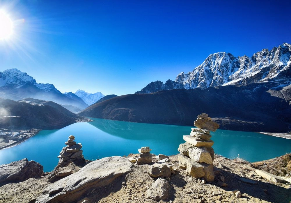
The Gokyo Lakes are a system of 6 interconnected oligotrophic glacial lakes in the Khumbu region of Solukhumbu District, ranging in elevation from 4,700 to 5,000 meters. Gokyo Lake (the third lake, also called Dudh Pokhari) at 4,700 meters is the central and most visited of the 6.
Why Are the Gokyo Lakes Considered Sacred?
The Gokyo Lakes are considered sacred because they are one of the world's highest Ramsar-listed freshwater lake systems (designated in 2007), and they hold direct spiritual significance in Sherpa Buddhist tradition as abodes of Nāgas, water serpent deities who govern rainfall, fertility, and natural balance. Disturbing or polluting the lakes is believed to provoke Nāga wrath, bringing floods and crop failure.
The Hindu tradition also claims the lakes. Pilgrims call the third Gokyo Lake "Dudh Pokhari" (Milk Lake) and consider it sacred within the same Janai Purnima pilgrimage circuit that connects Gosaikunda. Some Hindu texts list the Gokyo lakes as part of a broader network of sacred high-altitude water bodies across the Himalayas.
The Ramsar designation of 2007 formally recognized the ecological sanctity of all 6 lakes within a 7,770-hectare wetland complex. This status restricts fishing, bathing, and waste disposal within the lake perimeters, protections that align directly with centuries-old Sherpa cultural norms.
What Activities Can Visitors Enjoy Around the Gokyo Lakes?
Visitors enjoy 5 primary activities around the Gokyo Lakes: trekking to Gokyo Ri summit (5,357 m) for panoramic Everest views, crossing the Ngozumpa Glacier (Nepal's longest glacier at 36 km), visiting all 6 lakes on a 2-day exploration loop, observing migratory bar-headed geese, and attending the annual Mani Rimdu festival at Tengboche Monastery (3 days' walk away).
Gokyo Ri at 5,357 meters offers one of the most photographically celebrated viewpoints in the Himalayas, with simultaneous views of Everest (8,849 m), Lhotse (8,516 m), Makalu (8,485 m), and Cho Oyu (8,188 m), 4 of the world's 6 highest peaks, within a single visual frame.
The 6th Gokyo Lake (Ngojumba Tsho) at approximately 5,000 meters remains one of the least-visited points on the entire Everest region trail system. Trekkers who extend 1 extra day beyond the 5th lake encounter near-total solitude at elevations that most tourists never reach.
Gokyo Lakes Trek
The Gokyo Lakes Trek runs 12 to 15 days from Lukla (2,860 m), reached by a 35-minute mountain flight from Kathmandu. The route ascends through Namche Bazaar (3,440 m), Dole (4,200 m), Machhermo (4,470 m), and Gokyo (4,700 m).
A Sagarmatha National Park entry permit (NPR 3,000) and TIMS card apply. The park boundary begins at Monjo, a 2-day walk from Lukla. Acclimatization days at Namche Bazaar and Machhermo are standard protocol, reducing acute mountain sickness (AMS) risk significantly.
The Gokyo Lakes Trek is frequently combined with the Everest Base Camp Trek via the Cho La Pass (5,420 m), creating the "Everest–Gokyo Circuit", a 18-to-21-day route considered one of the most complete Himalayan treks available.
4. Rara Lake
Rara Lake lies at 2,990 meters above sea level in Mugu District, Karnali Province, Nepal's most remote lake and the largest lake by surface area in the country, covering 10.8 square kilometers. It sits within the Rara National Park, Nepal's smallest national park at 106 square kilometers, which was specifically demarcated to protect the lake and its surrounding conifer forests.
What Natural Beauty Surrounds Rara Lake?
Rara Lake is surrounded by dense Himalayan conifer forests (blue pine, oak, and juniper), snow-capped peaks of the Kanjiroba Himal range, alpine meadows, and 4 distinct shoreline environments, including marshy inlets used by migratory waterfowl, rocky outcrops, sandy beaches, and forested slopes descending directly to the water's edge.
The lake's color shifts visibly across the day. At dawn, the surface appears deep blue due to high clarity and shallow light angles. By midday, it shifts to turquoise under direct sun. At dusk, reflected snowpeaks turn it golden. This color variation results from the lake's high transparency, Secchi depth measurements exceed 10 meters, indicating exceptionally low turbidity.
Rara Lake supports 23 fish species, including the Himalayan snow trout (Schizothorax), which local communities harvest sustainably. The surrounding park hosts 51 mammal species, including the Himalayan black bear, red panda, grey wolf, and the elusive snow leopard.
How Can Visitors Explore Rara National Park?
Visitors explore Rara National Park through 3 primary methods: a 4-to-6-day trek from Jumla via Dhotu and Bumra (the most common overland route), a direct charter flight from Kathmandu to Talcha Airport (2,900 m) followed by a 3-hour walk, or a 2-day trek from Gamgadhi, the district headquarters of Mugu.
The park entry fee is NPR 3,000 for foreign nationals, with an additional Karnali Province conservation fee of NPR 100. Park regulations prohibit fishing without a special permit, open campfires within 1 kilometer of the lake, and motorized watercraft on the lake surface.
A single circuit trail of 9.2 kilometers circumnavigates the entire lake. Completing this walk takes 3–4 hours at a moderate pace and provides access to all 4 shoreline environments. The north shore offers the clearest mountain reflections; the south shore near Rara village gives the most direct view of the Kanjiroba range.
Rara Lake Trek
The Rara Lake Trek spans 7 to 10 days from Jumla (2,300 m), itself accessible by a 45-minute flight from Nepalgunj or a 2-day flight from Kathmandu. The overland route from Jumla to Rara covers 65 kilometers through pine and oak forests, crossing 3 high passes above 3,800 meters.
Altitude variation across the Rara Trek is more gradual than most Himalayan trails, making it accessible to trekkers with moderate fitness. Daily elevation gain averages 400–600 meters. The highest point on the standard route is Chuchemara Danda (4,087 m), which provides the first aerial view of the lake before the descent to its shore.
Rara is Nepal's least-visited major trek destination, fewer than 2,000 foreign trekkers register annually. This low traffic volume means the lake and its trails remain in near-pristine condition, making it one of the most rewarding wilderness experiences in the Himalayan region.
5. Shey Phoksundo Lake
Shey Phoksundo Lake stands at 3,611 meters above sea level in Dolpo District, Karnali Province. It is Nepal's deepest lake, with a maximum depth of 145 meters, and its surface color, an intense turquoise that local Tibetan communities describe as "peacock-blue", results from limestone-filtered glacial meltwater rather than algae or suspended sediment.
Why Is Shey Phoksundo Lake Important to Local Communities?
Shey Phoksundo Lake is important to local communities because it sits at the spiritual core of the Bön religious tradition, the pre-Buddhist shamanistic faith of Tibet and Dolpo, and the surrounding Shey Phoksundo National Park boundaries were drawn in part to protect the sacred landscape around it. The Tibetan word "Phoksundo" refers to a local Nāga deity believed to inhabit the lake.
3 specific cultural dimensions define the lake's importance. First, the Bon monastery of Ringmo village, located directly on the lake's eastern shore, is one of 7 surviving Bön practice centers in Nepal and dates back over 1,000 years. Second, the lake and its surrounding landscape feature prominently in Peter Matthiessen's 1978 book The Snow Leopard, one of the most recognized accounts of Himalayan spiritual pilgrimage in Western literature. Third, local Ringmo villagers practice a traditional restriction against fishing or swimming in the lake, observing that disturbing the water invites floods downstream.
The lake also serves as the primary water source for the Ringmo village of approximately 150 people, and downstream flows feed the Phoksundo River, which joins the Suli Gad and supports agricultural communities 2,000 meters below.
What Should Travelers Know Before Visiting Shey Phoksundo Lake?
Travelers visiting Shey Phoksundo Lake must know 3 critical permit and logistical requirements: a Restricted Area Permit for Dolpo (USD 500 per person for the Lower Dolpo region, valid for 10 days), a Shey Phoksundo National Park entry permit (NPR 3,000), and a mandatory registered guide, solo travel without a guide is not legally permitted in restricted zones of Dolpo.
The journey to the lake from Kathmandu takes 2–3 days: Kathmandu to Nepalgunj by flight (1 hour), Nepalgunj to Juphal Airport (45 minutes), then a 2-day trek to the lake via Dunai and Chhepka. The Phoksundo waterfall, at 107 meters, one of Nepal's tallest, is passed on the final approach, providing a dramatic natural landmark before the lake comes into view.
Weather windows are narrow. The optimal visiting season spans May–June and September–October. The monsoon affects Lower Dolpo less severely than the rest of Nepal due to its trans-Himalayan position, but July–August trail conditions above 4,000 meters remain unpredictable. Winter snowfall closes the Kagmara La and Kang La passes, the 2 primary high routes into the region, between November and April.
Phoksundo Lake Trek
The Phoksundo Lake Trek runs 10 to 14 days on the standard Lower Dolpo circuit: Juphal–Dunai–Chhepka–Phoksundo Lake–Ringmo–Phoksundo Lake (return) or continuing via Shey Gompa to Upper Dolpo. The Lower Dolpo circuit covers 120 kilometers of trail.
The trek crosses the Kagmara La Pass (5,115 m) on the most common extended route, making it a high-altitude undertaking that demands prior trekking experience at altitude. Daily walking time averages 6–8 hours on mid-route days.
The restricted area status of Dolpo limits annual visitors to fewer than 1,500, a figure enforced partly through the USD 500 permit cost and partly through geographic remoteness. This restriction preserves both the cultural authenticity of Ringmo village and the ecological integrity of Shey Phoksundo National Park, Nepal's largest national park at 3,555 square kilometers.
6. Panchpokhari Lake
Panchpokhari, translating directly from Nepali as "Five Lakes", is a cluster of 5 sacred glacial lakes located at 4,100 meters above sea level in the Sindhupalchok District, approximately 130 kilometers northeast of Kathmandu. The lakes sit on a high ridge above the Helambu region and remain one of the most important pilgrimage destinations in the Tamang and Hindu traditions of Nepal.
What Religious Festivals Are Celebrated at Panchpokhari?
The primary religious festival at Panchpokhari is Janai Purnima (full moon of the Nepali month Shrawan, typically August), when thousands of Hindu and Tamang pilgrims trek to the lakes to bathe, receive sacred threads (janai), and perform puja rituals. The gathering at Panchpokhari is considered spiritually equivalent to bathing at Gosaikunda for pilgrims unable to reach the higher lake.
The 5 lakes carry individual names, Panchpokhari, Naupokhari, Shivapuri, Indrapokhari, and Brahmapokhari, each associated with a specific deity. Brahma, Vishnu, Shiva, Indra, and the divine feminine (Shakti) are represented collectively by the 5 water bodies, making the cluster a complete cosmological map in physical form.
The Tamang communities of Sindhupalchok additionally celebrate Loshar (Tibetan New Year) near the lakes in February, observing a separate seasonal pilgrimage that blends Bön, Buddhist, and animist traditions. This dual-tradition festival calendar makes Panchpokhari a genuinely multi-faith pilgrimage site.
How Difficult Is the Trek to Panchpokhari?
The trek to Panchpokhari is moderately challenging, rated suitable for trekkers with basic fitness and no prior high-altitude experience, with a 3-to-4-day round trip from Melamchi Pul Bazaar (870 m) ascending to 4,100 meters via Talamarang and Sermathang villages, the same lower Helambu corridor explored on the Helambu trek.
Total one-way distance covers 42 kilometers, with cumulative elevation gain of 3,230 meters. The steepest section occurs on day 2, between Pauwa Danda (2,800 m) and the lake ridge (4,100 m), where trekkers gain 1,300 meters in a single day on a well-defined but consistently steep trail.
Teahouse accommodation is available at Sermathang (2,600 m) and limited seasonal camping sites exist near the lakes. The trail does not require a special restricted area permit, only the standard TIMS card (NPR 2,000). Porters and guides are available from Melamchi Pul Bazaar, which is reachable by a 3-hour bus journey from Kathmandu.
7. Phewa Lake
.webp)
Phewa Lake sits at 787 meters above sea level in Pokhara, the Gandaki Province of Nepal. It is the second-largest lake in Nepal by surface area, covering 4.4 square kilometers, and functions as the most accessible sacred lake in the country, reachable directly from Pokhara city center within 10 minutes.
What Attractions Can Visitors Enjoy Around Phewa Lake?
Visitors enjoy 7 documented attractions around Phewa Lake: the Tal Barahi Temple on a mid-lake island (accessible by rowboat), the Lakeside promenade with international restaurants and equipment rental shops, paragliding from Sarangkot Hill (1,592 m) with landings on the lakeshore, sunrise and sunset reflections of the Annapurna range, boating and kayaking on the lake surface, hiking to the World Peace Stupa (Shanti Stupa) on the south ridge above the lake, and the International Mountain Museum 3 kilometers from the Lakeside.
The Tal Barahi Temple, a 2-story pagoda dedicated to the goddess Barahi, an incarnation of Durga, is Phewa Lake's central religious structure and the most photographed temple in the Pokhara valley. Pilgrims row to the island temple daily, particularly on Saturdays when devotional offerings increase significantly.
Paragliding from Sarangkot to the Phewa Lakeside covers 8 kilometers of aerial distance and 804 meters of elevation loss over approximately 30 minutes. On clear mornings between October and December, paragliders fly with the Annapurna massif, Machhapuchhre (6,993 m), and Dhaulagiri (8,167 m) as a direct backdrop, one of the most visually striking adventure tourism experiences in Asia.
Why Is Phewa Lake Important to Pokhara Tourism?
Phewa Lake is important to Pokhara tourism because it generates the primary economic activity for the Lakeside district, Nepal's second-largest tourist hub, by anchoring 3 major revenue streams: water-based recreation, religious tourism to Tal Barahi Temple, and the visual spectacle of Annapurna reflections that makes Pokhara one of the most photographed cities in South Asia.
The lake directly employs over 2,000 people in Pokhara through boat operations, lakeside hospitality, adventure sports, and religious services. Phewa Lake receives more than 200,000 visitors annually, a figure that exceeds visitor counts at Gosaikunda, Tilicho, and Rara combined.
The lake also faces documented environmental pressure. Sedimentation from the Harpan Khola river reduces the lake's surface area by an estimated 0.2% annually. Phewa's depth has decreased from an average of 8.6 meters in 1994 to 4.8 meters in recent measurements, making lake conservation a direct concern for Pokhara's long-term tourism economy.
Pokhara Day Tour
A Pokhara Day Tour built around Phewa Lake covers 6 key stops: Phewa Lakeside at dawn for Annapurna reflections, a rowboat trip to Tal Barahi Temple, the World Peace Stupa hike (1.5 hours from Damside), Sarangkot viewpoint for sunset over Phewa Lake, the Davi's Falls underground waterfall, and the Gupteshwor Cave, all within 25 kilometers of the city center.
Pokhara is accessible from Kathmandu by a 25-minute flight (NPR 5,000–12,000 one-way) or a 6-to-7-hour drive via the Prithvi Highway. No trekking permit is required for Pokhara city activities. Rowboats rent for NPR 800–1,200 per hour at the Lakeside ghat.
Pokhara also functions as the gateway city for both the Annapurna Circuit and the Annapurna Base Camp Trek, meaning most travelers who visit Tilicho Lake or the broader Annapurna region pass through Phewa Lakeside at the start or end of their trek.
How Should Travelers Plan a Journey to Nepal's Sacred Lakes?
Travelers planning a journey to Nepal's sacred lakes follow a 4-step planning framework: select lakes based on altitude experience and available time, arrange required permits in advance (all permits are now processed through the Department of Immigration or TAAN-registered agencies), confirm seasonal access windows for each target lake, and build in 2 acclimatization days for any itinerary that exceeds 3,500 meters.
The following table organizes the 7 lakes by elevation, permit requirement, and optimal season:
Lake | Elevation | Permit Required | Best Season |
Phewa Lake | 787 m | None | Year-round |
Rara Lake | 2,990 m | NP Entry + TIMS | Oct–Nov, Mar–May |
Shey Phoksundo | 3,611 m | Restricted Area + NP | May–Jun, Sep–Oct |
Panchpokhari | 4,100 m | TIMS | Aug (pilgrimage), Oct–Nov |
Gosaikunda | 4,380 m | NP Entry + TIMS | Jul–Aug (pilgrimage), Oct–Nov |
Gokyo Lakes | 4,700 m | ACAP + TIMS | Oct–Nov, Mar–May |
Tilicho Lake | 4,919 m | ACAP + TIMS | Oct–Nov, May–Jun |
First-time visitors to Nepal benefit from beginning with Phewa Lake in Pokhara before attempting any high-altitude lake. This approach establishes a geographic and cultural baseline. Travelers combining multiple lakes across a single trip of 21+ days plan a logical east-to-west or region-by-region itinerary: Khumbu (Gokyo) → Kathmandu valley → Langtang (Gosaikunda) → Pokhara (Phewa/Tilicho) → Karnali (Rara/Phoksundo).
Can Guided Nepal Tours Help Travelers Explore Sacred Lakes?
Guided Nepal tours help travelers explore sacred lakes by providing 4 critical services that self-organized trekkers consistently underestimate: restricted area permit processing (mandatory for Dolpo and some Upper Mustang routes), acclimatization management from certified altitude medicine-trained guides, logistics in remote areas without road access (Rara, Dolpo), and cultural interpretation that transforms a scenic lake visit into a meaningful encounter with living religious traditions.
For Tilicho and Gokyo Lakes, experienced trekking guides with WFR (Wilderness First Responder) or WFA (Wilderness First Aid) certification reduce AMS-related evacuation rates by providing daily oxygen saturation monitoring. The standard evacuation from Tilicho Lake to Kathmandu by helicopter costs USD 3,000–5,000, a figure that underscores the practical value of altitude-experienced guidance.
Government-registered trekking agencies (TAAN-member companies) process all restricted area permits legally and hold agency liability during the trek. Travelers booking through non-registered operators risk permit rejection at checkpoints and loss of insurance coverage for mountain evacuations.
What Are the Key Takeaways About Nepal's Sacred Lakes?
Nepal's 7 sacred lakes represent a complete spectrum of Himalayan lake experiences, from Phewa's accessible lakeside culture at 787 meters to Tilicho's extreme high-altitude wilderness at 4,919 meters, and from Gosaikunda's mass Hindu pilgrimage to Shey Phoksundo's restricted Bön heritage.
6 core takeaways define informed travel to Nepal's sacred lakes:
Permits vary significantly by lake: Dolpo requires a USD 500 restricted area permit; Phewa requires none. Planning permits 4–6 weeks in advance prevents departure delays.
Altitude determines fitness requirements: Lakes above 4,000 meters (Gosaikunda, Gokyo, Tilicho, Panchpokhari) require prior trekking experience at altitude or a structured acclimatization itinerary.
Religious calendars shape crowd patterns: Gosaikunda and Panchpokhari draw 10,000–15,000 pilgrims during Janai Purnima (August); visiting 2 weeks before or after reduces congestion while preserving cultural atmosphere.
Remote lakes (Rara, Phoksundo) reward extra logistics effort: Both require domestic flights into mountain airstrips and multi-day trails, but they deliver the lowest visitor density of any significant lake trek in Asia.
Environmental pressures are real and accelerating: Phewa Lake's depth has halved in 30 years; Gosaikunda faces waste accumulation from pilgrim traffic; responsible trekking practices (pack-in/pack-out, no plastic, certified guides) directly protect these ecosystems.
Nepal's sacred lakes form a culturally interconnected landscape: Hindu mythology, Tibetan Buddhism, and Bön tradition each claim multiple lakes, making a multi-lake journey across Nepal a genuine exploration of Himalayan religious geography.
Travelers who approach Nepal's sacred lakes with awareness of their religious context, seasonal conditions, and ecological fragility experience these landscapes with the depth they deserve, and contribute to the preservation that makes them worth visiting at all.


