The Mardi Himal Trek is a short high-altitude trek in Nepal’s Annapurna Conservation Area that climbs from Kande above Pokhara to High Camp and Mardi Himal Base Camp at about 4,500 meters. Among Annapurna treks, it stands out for its unusually close and sustained views of Machapuchare, Annapurna South, and Hiunchuli, its quiet ridge-line trail, and its far lower traffic than Annapurna Base Camp or Poon Hill. The route moves quickly from rhododendron forest to alpine grassland and open mountain terrain, giving trekkers a rare combination of scenic variety, fast elevation gain, and several days of continuous Himalayan panorama.
Mardi Himal is unique not because it is harder or more famous than other Annapurna routes, but because it delivers a more intimate trekking experience in less time. Fewer teahouses, fewer side settlements, and a narrower trail create a quieter atmosphere, while the trek’s 5-to-7-day itinerary makes it one of the most accessible ways to reach a high Himalayan viewpoint from Pokhara without technical climbing. For trekkers seeking solitude, strong Machapuchare views, authentic Gurung hospitality, and a less commercial alternative to the region’s busier routes, the Mardi Himal Trek offers one of the most balanced experiences in the Annapurna region.
Where Is the Mardi Himal Trek Located Within the Annapurna Region?
The Mardi Himal Trek is most commonly done from Kande to Siding, though itineraries vary and some trekkers start or link in from places such as Phedi, Landruk, or Ghandruk. High Camp and Mardi Himal Base Camp are usually high points or turnaround points, not the usual final endpoint of the trek.
The Annapurna Conservation Area Project (ACAP) was launched in 1986, and the Annapurna Conservation Area was formally gazetted as a conservation area in 1992; it covers 7,629 square kilometers and is managed by the National Trust for Nature Conservation, contains 4 primary trekking corridors: Annapurna Circuit, Annapurna Base Camp, Poon Hill, and Mardi Himal. The Mardi Himal corridor occupies the southeastern ridge of the Annapurna massif.
Pokhara city, the nearest urban gateway at 822 meters elevation, sits 7 kilometers southwest of the trek's starting point. The trail ascends northeast through 3 distinct elevation bands: forest zone (1,770–2,600 meters), rhododendron-oak transition zone (2,600–3,200 meters), and alpine grassland zone (3,200–4,500 meters).
The Mardi Himal Trek is usually walked as a quieter ridge-side alternative to Annapurna Base Camp, but it can also be linked with ABC and other Annapurna routes on longer combined itineraries. The Mardi Himal Trek is most commonly done from Kande to Siding, though itineraries vary and some trekkers start or link in from places such as Phedi, Landruk, or Ghandruk. High Camp and Mardi Himal Base Camp are usually high points or turnaround points, not the usual final endpoint of the trek. This geographic isolation from the ABC trail network directly determines the trek's low visitor density.
How Does Its Position Near Machapuchare Shape the Trek Experience?
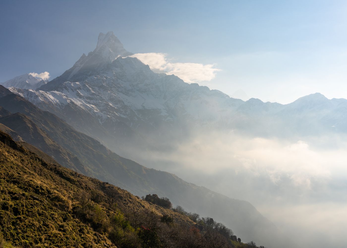
Machapuchare's position 6 kilometers northwest of the Mardi Himal ridge creates a direct, unobstructed sightline from every major viewpoint on the trek, making the 6,993-meter peak visible for 4 consecutive trail days, a sightline duration unavailable on any other Annapurna route.
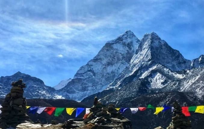
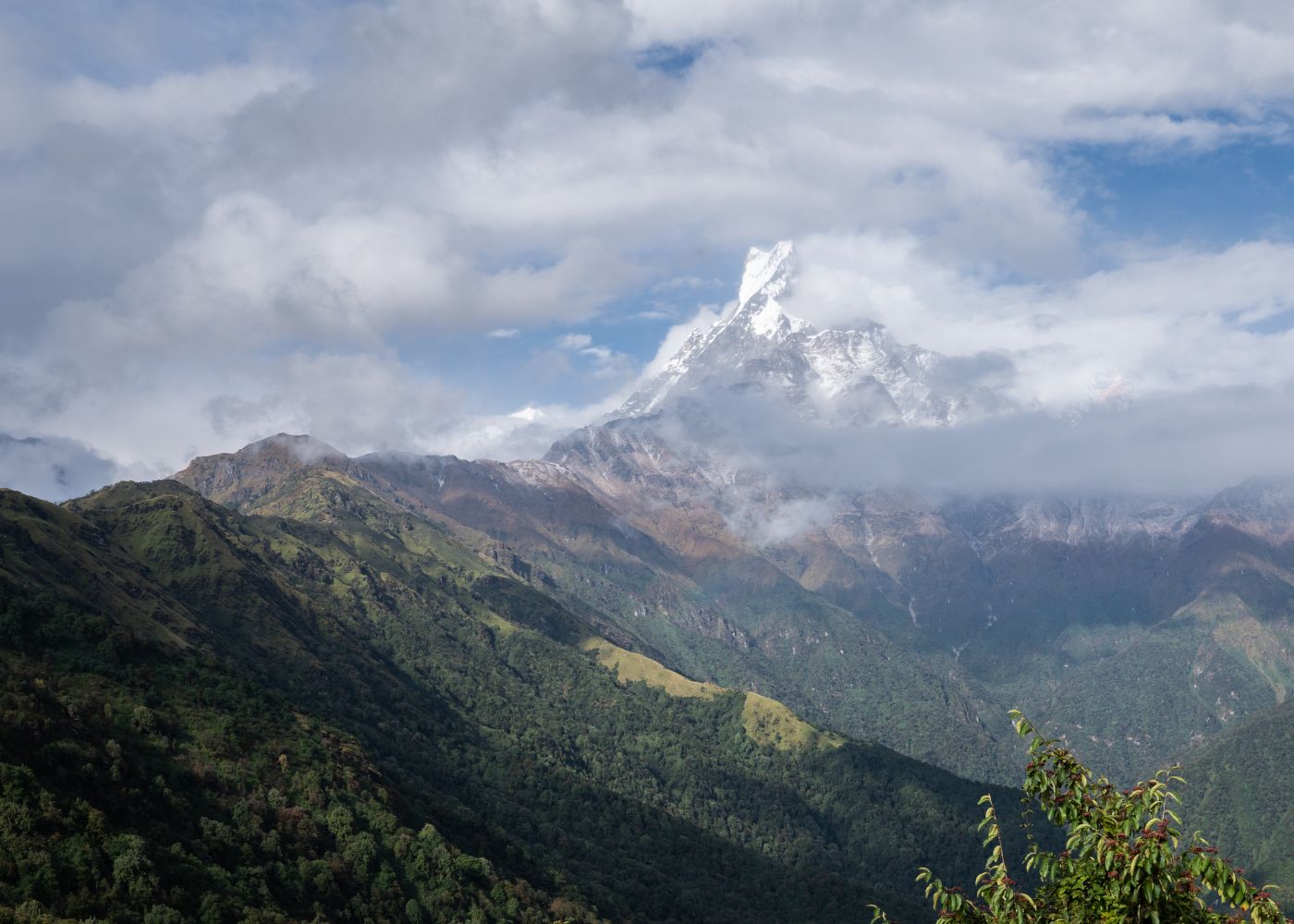
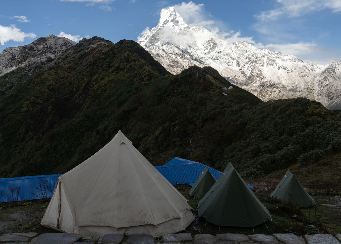
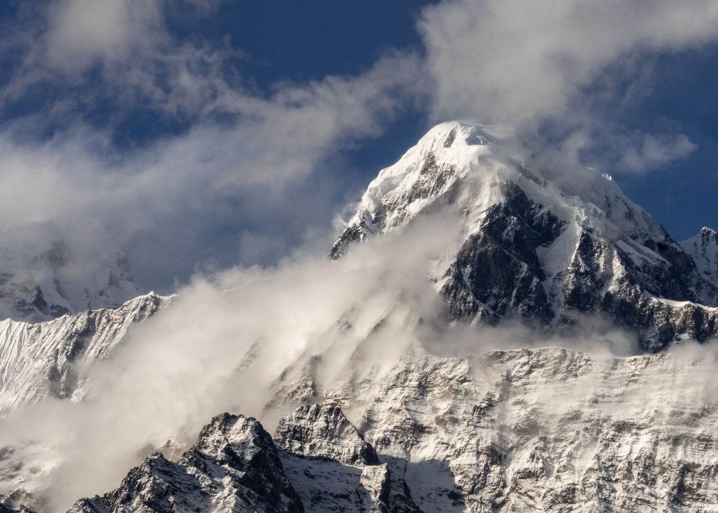
Machapuchare, defined as a 6,993-meter peak in the Annapurna Himalayan range, named "Fishtail Mountain" for its twin-summit profile, protected from climbing since 1964 under Nepal government regulation, dominates the western horizon across the entire Mardi Himal ridge corridor.
At High Camp (3,550–3,580 meters), the angular distance between the trekker's eye level and Machapuchare's summit measures approximately 35 degrees. This proximity geometry creates a visual scale effect where Machapuchare appears proportionally larger than on the ABC approach, where trekkers view it from within the sanctuary basin at a less favorable angle.
The trek's ridge orientation runs parallel to Machapuchare's south face. This alignment means trekkers walk alongside the mountain rather than toward it, maintaining consistent viewing distance across 12 kilometers of ridge trail. Sunrise illumination on Machapuchare's east face occurs at 06:14 local time during October, producing the alpenglow effect most associated with High Camp photography.
Why Does Its Route Feel More Hidden Than Other Annapurna Trails?
The Mardi Himal Trek route feels more hidden because it lacks signage integration with the main Annapurna trail network, does not appear on pre-2012 trekking maps of the region, and was formally opened to trekkers only in 2012 by the Nepal Tourism Board, 4 decades after ABC and Poon Hill routes were established.
The Nepal Tourism Board, defined as the government authority under the Ministry of Tourism responsible for promoting and regulating Nepal's tourism infrastructure, officially designated the Mardi Himal Trek as a formal trekking route in 2012. Before this designation, local Gurung communities used the ridge path as a seasonal herding trail for livestock movement between Pokhara valley and alpine grazing grounds.
The trail's trailhead at Kande sits off the main Pokhara–Baglung Highway, accessed via a side road without prominent directional signage visible from the highway. ABC trekkers traveling the same highway pass within 4 kilometers of the Mardi Himal trailhead without any intersection between the two routes.
3 additional factors reinforce the route's hidden character:
-
Absence of the route from most international trekking agency standard itinerary catalogs before 2016
-
No traditional teahouse settlement at the trailhead comparable to Nayapul (ABC) or Tikhedhunga (Poon Hill)
-
Ridge-line trail positioning that is invisible from Pokhara's lake district viewpoints, which face the Annapurna South and Machhapuchhre directly
What Makes the Mardi Himal Trek Feel Less Crowded Than Other Routes?
The Mardi Himal Trek records fewer than 8,000 annual trekking permits issued, compared to 80,000+ permits for the Annapurna region collectively, placing daily trail traffic below 30 trekkers on most ridge sections, a density 6 times lower than peak-season ABC trail counts.
Trekking permit data from the Annapurna Conservation Area Project (ACAP), defined as the permit and conservation management body operating within the 7,629-square-kilometer Annapurna Conservation Area, shows the Mardi Himal corridor receives approximately 7–8% of total Annapurna trekker volume annually.
The trail's single-entry, single-exit linear structure limits simultaneous trekker presence. ABC operates as a basin approach with multiple feeder trails from Ghorepani, Ghandruk, and Chomrong, creating convergence points where 200+ trekkers pass through on peak days in October and November.
The Mardi Himal ridge has 4 designated camping/teahouse stops: Forest Camp, Low Camp, High Camp, and Mardi Himal Base Camp. Each stop accommodates a maximum of 40–60 overnight guests across all available teahouses combined, creating a natural capacity ceiling that prevents the density surges characteristic of ABC's Machapuchare Base Camp, which hosts 300+ trekkers on busy nights.
How Does Trail Traffic Compare With Annapurna Base Camp and Poon Hill?
Annapurna Base Camp records 300–400 trekkers per day at peak season (October–November), Poon Hill records 500–700 trekkers at the viewpoint on peak mornings, and Mardi Himal High Camp records 15–35 trekkers on equivalent peak days, a 10-to-20-times difference in daily foot traffic volume. For a full breakdown of how these two routes differ across difficulty, scenery, and cost, see the Mardi Himal vs Annapurna Base Camp comparison.
The following table presents a direct traffic comparison across the 3 most-visited Annapurna trekking routes based on ACAP permit and trail count data:
|
Route |
Annual Permits (approx.) |
Peak-Day Trail Count |
Trail Type |
|
Annapurna Base Camp |
60,000–70,000 |
300–400 at ABC |
Basin convergence |
|
Poon Hill |
100,000+ |
500–700 at viewpoint |
Multi-entry loop |
|
Mardi Himal Trek |
7,000–8,000 |
15–35 at High Camp |
Single ridge spine |
Poon Hill, defined as a 3,210-meter viewpoint above Ghorepani village, Myagdi District, accessed via the Ghorepani-Poon Hill circuit, draws high day-visitor volume because Pokhara-based tour operators include the sunrise viewpoint as a standard 4-day package. Mardi Himal has no equivalent day-visitor infrastructure; reaching High Camp requires 3 full trekking days from the trailhead.
Why Do Fewer Teahouses and Side Settlements Change the Atmosphere?
Fewer teahouses on the Mardi Himal Trek eliminate the commercial corridor atmosphere characteristic of ABC and Poon Hill, where teahouses appear every 1–2 kilometers with generator noise, menu boards, Wi-Fi signage, and vendor activity, reducing the trek to 8–10 total accommodation points across its full length.
The Mardi Himal Trek has 8–10 active teahouses operating across its 4 main stops, compared to 60+ teahouses on the ABC approach corridor between Nayapul and ABC. This 6-to-1 ratio determines the ambient environment trekkers experience between stops.
Teahouse, defined in Himalayan trekking context as a family-operated guesthouse providing accommodation and meals along established trekking routes, typically built with stone or timber construction, on the Mardi Himal route average 6–12 beds per establishment. ABC-route teahouses at Chomrong and Chhomrong average 20–40 beds, with dining halls seating 50+ trekkers simultaneously.
The absence of side settlements removes 3 atmospheric elements common on busier routes:
-
No porter rest areas with large group congregation points
-
No village market stalls selling trekking gear and trinkets along the trail
-
No monastery or permit checkpoint queues that concentrate foot traffic at single points
Forest Camp (2,600 meters) and Low Camp (2,985 meters) each contain 2–3 teahouses separated by open forest. Trekkers walk 10–15 minutes between teahouses rather than passing through a continuous strip of guesthouses. This spacing preserves natural ambient sound, wind, bird calls, stream noise, rather than generator hum and kitchen activity.
How Are the Mountain Views Different on the Mardi Himal Trek?
Mountain views on the Mardi Himal Trek differ from ABC and Poon Hill because the ridge elevation (2,600–4,500 meters) places trekkers above the tree line 2 days earlier in the itinerary, delivering unobstructed Himalayan panoramas for 3 consecutive trail days rather than the single viewpoint summit experience common on other routes.
The ridge-line geometry of the Mardi Himal Trek creates a 180-degree north-facing panorama from Low Camp onward. This panorama includes 6 peaks above 6,000 meters: Machapuchare (6,993 meters), Annapurna South (7,219 meters), Hiunchuli (6,441 meters), Tent Peak (5,663 meters), Fluted Peak (6,691 meters), and Mardi Himal itself (5,587 meters).
ABC trekkers view the Annapurna massif from inside the sanctuary basin, looking upward at peaks from 4,130 meters. The basin perspective places trekkers directly beneath the peaks but reduces horizontal separation, compressing the panoramic field of view. Mardi Himal's ridge perspective maintains 4–10 kilometers of horizontal separation from the primary peaks, allowing full summit-to-base visibility.
Poon Hill's panorama covers a wider east-west arc (Dhaulagiri to Manaslu), but delivers this view from a single 30-minute sunrise stop at 3,210 meters. Mardi Himal trekkers walk within this panoramic zone for 8–12 hours of active trekking across the upper ridge section.
Why Is Machapuchare So Dominant on This Trail?
Machapuchare is dominant on the Mardi Himal Trail because the trail's northeast-oriented ridge positions the trekker's line of travel directly south of Machapuchare's main massif, maintaining a 5–8 kilometer viewing distance from the peak across 12 kilometers of ridge trail, the closest prolonged approach to Machapuchare available on any open trekking route in Nepal.
Machapuchare's protected status, established under Nepal government climbing regulations in 1964 following a near-summit attempt by Wilfrid Noyce and David Cox, who stopped 150 meters short of the summit to honor the mountain's sacred status, means no trekking route enters the mountain's immediate approach zone. The Mardi Himal ridge is the only trail that maintains a sustained close-distance parallel to Machapuchare's southern flanks.
From High Camp at 3,550–3,580 meters, Machapuchare's summit at 6,993 meters rises 2,020 meters directly above the trekker's position. This 2,020-meter vertical differential, combined with the 5-kilometer horizontal distance, creates a summit elevation angle of approximately 22 degrees. At ABC (4,130 meters), the equivalent angle to Machapuchare measures 15 degrees due to increased horizontal distance and near-equivalent base elevation.
The mountain's twin-summit profile, its defining visual attribute, is most clearly visible from the Mardi Himal High Camp perspective. From Pokhara and most other viewpoints, Machapuchare's foreground ridge obscures the secondary summit. The Mardi Himal ridge angle reveals both summits simultaneously.
How Do Annapurna South and Hiunchuli Add to the Scenery?
Annapurna South (7,219 meters) and Hiunchuli (6,441 meters) form the eastern and western flanks of the Mardi Himal Trek's primary panorama, visible from Low Camp (2,985 meters) onward across 4 days of trekking, with both peaks appearing at greater angular width from the Mardi Himal ridge than from the ABC sanctuary floor.
Annapurna South, defined as a 7,219-meter peak forming the southern sub-summit of the Annapurna I massif (8,091 meters), first climbed by a Japanese expedition in 1964, sits 14 kilometers northwest of High Camp. Its south face, a 3,000-meter vertical wall of mixed rock and glacier, dominates the western quadrant of the High Camp panorama.
Hiunchuli, defined as a 6,441-meter satellite peak of Annapurna South, located 11 kilometers northwest of the Mardi Himal ridge, appears as a distinctive pyramid form between Machapuchare and Annapurna South in the panoramic field. Hiunchuli's lower elevation relative to neighboring peaks places its summit visible above the horizon without atmospheric distortion at most viewing times.
The Mardi Himal Base Camp approach (4,200–4,500 meters) brings trekkers to a point where all 3 peaks, Machapuchare, Annapurna South, and Hiunchuli, fill the upper 60 degrees of the northern horizon simultaneously. This concentrated peak density within a single visual field distinguishes the Mardi Himal upper trail from routes that space major peaks across wider azimuthal ranges.
What Makes the Ridge-Line Vantage Points So Memorable?
Mardi Himal's ridge-line vantage points are memorable because they deliver continuous above-treeline panoramic views for 6–8 hours of walking per day across the upper trail section, an immersive visual duration that differs structurally from the point-destination viewpoints at Poon Hill (30 minutes) and ABC (2–4 hours in the sanctuary).
The upper ridge section between Low Camp (2,985 meters) and High Camp (3,550–3,580 meters) runs 9 kilometers along an open spine with no significant forest cover or valley walls obstructing the northern panorama. Trekkers remain exposed to the full Himalayan view for the entire 5–6 hour walking day on this section.
4 specific vantage points on the ridge deliver the most concentrated visual impact:
-
Low Camp viewpoint (2,985 meters): First unobstructed Machapuchare sightline, effective from 07:00 to 16:00 in clear conditions
-
Middle Camp ridge (3,450 meters): Full panorama including Annapurna South and Hiunchuli enters the frame simultaneously
-
High Camp upper terrace (3,550–3,580 meters): 360-degree view including southern Pokhara valley and northern Himalayan wall
-
Mardi Himal Base Camp approach (4,200–4,500 meters): Closest approach point to the Mardi Himal peak itself, with glacier moraines visible
The ridge's east-west exposure means morning light illuminates the Annapurna South face while afternoon light shifts to Machapuchare's eastern ridgeline, creating 2 distinct photographic conditions within a single viewpoint day.
How Does the Landscape Change Along the Mardi Himal Trek?
The Mardi Himal Trek traverses 4 distinct landscape zones across 22 kilometers of trail: subtropical broadleaf forest (1,770–2,200 meters), rhododendron-oak mixed forest (2,200–3,000 meters), alpine shrub and grassland (3,000–3,800 meters), and rocky glacial moraine terrain (3,800–4,500 meters), all within a 3-day ascent.
The Annapurna Conservation Area, Nepal's largest protected zone at 7,629 square kilometers, records 22 forest types within its boundaries. The Mardi Himal trail corridor intersects 4 of these types in direct vertical sequence, creating one of the highest landscape diversity densities per kilometer of any Himalayan trekking route.
The transition from subtropical forest to alpine terrain occurs across 2,700 meters of vertical gain over 22 kilometers of horizontal trail distance, the full Mardi Himal altitude profile breaks this down camp by camp. This 1:8 vertical-to-horizontal ratio creates rapid, perceptible landscape shifts. Trekkers leaving Kande (1,770 meters) in warm subtropical humidity arrive at High Camp (3,550–3,580 meters) in cold alpine wind conditions within 3 days.
Vegetation markers define each zone precisely:
-
Schima-Castanopsis broadleaf canopy dominates 1,770–2,200 meters
-
Rhododendron arboreum (tree rhododendron, height 10–15 meters) dominates 2,200–3,200 meters
-
Juniper scrub and Himalayan thistles appear at 3,200–3,800 meters
-
Bare scree and glacial outwash characterize 3,800–4,500 meters
Why Does the Trek Move So Quickly From Forest to Alpine Terrain?
The Mardi Himal Trek moves from forest to alpine terrain faster than any comparable Annapurna route because its ridge ascent profile gains 2,200 meters of elevation across 3 trail days, averaging 733 meters of daily elevation gain, compared to ABC's 5-day, 2,300-meter gain and the Annapurna Circuit's 14-day, 5,416-meter gain to Thorong La pass.
The ridge ascent structure eliminates the valley-floor traverses that extend other Annapurna itineraries. ABC trekkers walk through the Modi Khola valley for 3 days at elevations between 1,000 and 2,100 meters before beginning the true ascent to the sanctuary. Mardi Himal trekkers begin ascending the ridge spine from day one at Kande (1,770 meters).
Elevation profile data for the Mardi Himal Trek shows:
-
Day 1: Kande (1,770 m) to Forest Camp (2,600 m), 830-meter gain over 10 kilometers
-
Day 2: Forest Camp (2,600 m) to Low Camp (2,985 m), 385-meter gain over 6 kilometers
-
Day 3: Low Camp (2,985 m) to High Camp (3,550–3,580 m), 988-meter gain over 9 kilometers
The compact daily gain means trekkers reach the alpine zone (above 3,000 meters) by day 3 morning. At ABC, trekkers reach equivalent elevation on day 5 or 6 depending on the starting point. This compression creates the perception of rapid landscape transformation.
How Do Rhododendron Forests Add Seasonal Appeal?
Rhododendron forests add peak seasonal appeal to the Mardi Himal Trek during March and April, when Rhododendron arboreum blooms at 2,200–3,200 meters, covering 12 kilometers of the trail corridor with dense crimson and pink flowering canopy, an annual bloom cycle that transforms the Forest Camp and Low Camp sections into a color environment absent on non-forested ridge routes.
Rhododendron arboreum, defined as Nepal's national flower, a 10–15-meter tree species producing dense clusters of 15–20 deep red or pink flowers per branch, blooming at elevations between 1,500 and 3,500 meters between February and May, achieves maximum bloom density on the Mardi Himal trail between 2,200 and 2,800 meters in late March.
The Mardi Himal trail passes through 8 kilometers of continuous rhododendron-dominant forest between Badal Danda and Low Camp. This 8-kilometer flowering corridor contrasts with ABC's approach trail, which passes through rhododendron zones at Ghorepani (2,874 meters) for 2–3 kilometers before entering open terrain.
Seasonal trekking data from Pokhara-based agencies shows March–April bookings for Mardi Himal increase 40% above the annual monthly average, directly correlating with rhododendron bloom timing. October–November remains the primary trekking season for clear mountain views, but March–April offers the dual attraction of rhododendron color and high mountain visibility on cloudless mornings before 10:00.
What Makes the High Camp Section Feel Dramatic and Remote?
High Camp at 3,550–3,580 meters feels dramatic and remote because it sits on a narrow ridge with a 1,200-meter drop to the Mardi Khola valley on the east and open alpine grassland stretching to Mardi Himal Base Camp to the north, with the nearest road access point 18 kilometers and 3 hiking days away at Kande.
High Camp, defined as the uppermost established teahouse settlement on the Mardi Himal Trek at 3,550–3,580 meters, containing 3–4 stone-built teahouses with capacities of 8–15 beds each, occupies a ridge saddle measuring approximately 200 meters wide at its broadest point. The ridge saddle position creates exposure to winds from both east and west faces simultaneously.
The remoteness of High Camp results from 3 measurable factors:
-
Distance from road access: 18 kilometers of foot trail with no motorable path on any section
-
Teahouse capacity limit: Maximum 40–60 overnight trekkers across all establishments combined
-
Emergency extraction time: 6–8 hours minimum walking to reach Kande trailhead in daylight conditions
Night sky visibility at High Camp ranks among the highest available at any teahouse on Nepal's established trekking routes, with light pollution levels near zero due to absence of road infrastructure and electrical grid connection. High Camp teahouses operate on solar power systems averaging 200–400 watts per establishment.
Why Does the Mardi Himal Trek Offer a More Intimate Trekking Experience?
The Mardi Himal Trek offers a more intimate trekking experience because its structural characteristics, single ridge spine, 8–10 teahouses, and 22-kilometer trail length, create conditions where trekkers repeat contact with the same small group of fellow trekkers across all 3–4 days, replicating the social dynamic of pre-commercial Himalayan mountaineering expeditions.
Intimate trekking experience, defined in adventure tourism research as a journey characterized by consistent peer group size below 15 participants, natural environment encounters without human-made infrastructure visible, and reduced commercial activity along the route, depends on 4 structural variables: trail length, accommodation capacity, route accessibility, and daily visitor volume.
The Mardi Himal Trek satisfies all 4 intimacy criteria simultaneously. Its 22-kilometer length and 3-day minimum itinerary select for trekkers committed to the full experience rather than day visitors. Accommodation capacity at each stop (40–60 beds) limits the maximum peer group size to a manageable social environment.
Trekkers on the Mardi Himal route typically encounter the same 10–20 fellow trekkers at each teahouse stop across consecutive nights, creating familiarity and informal community absent from busier routes where overnight guests at Machapuchare Base Camp (ABC) number 200–300, producing anonymity rather than connection.
How Do Smaller Trails Create a Stronger Sense of Solitude?
Smaller trails on the Mardi Himal route create solitude because the path width averages 0.8–1.2 meters across most ridge sections, accommodating single-file walking only, compared to ABC trail widths of 1.5–3 meters that accommodate two-way porter and trekker traffic simultaneously, physically separating trekkers into sequential progression rather than group clustering.
Trail width directly determines social density. Single-file paths prevent the side-by-side walking that characterizes social trekking on wider routes. The Mardi Himal ridge trail's narrow profile results from low historical traffic volume, trails widen through repeated foot traffic over decades, and the Mardi Himal route's post-2012 designation means 14 years of formalized use compared to 50+ years on ABC.
Between High Camp and Mardi Himal Base Camp, the trail narrows to 0.6–0.8 meters on several exposed ridge sections, requiring careful single-file movement. No porter traffic operates on this upper section due to limited teahouse supply logistics. The absence of porter traffic, a constant feature of ABC, where 100+ porters move daily between Bamboo and Chhomrong, eliminates the most frequent human contact event on Himalayan trekking routes.
Trekkers on the ridge sections between Low Camp and High Camp average 8–12 minutes of trail time between encounters with other people during non-peak season (December–February), and 15–25 minutes during shoulder season (June–August).
Why Does the Simpler Teahouse Network Feel More Authentic to Some Trekkers?
The simpler teahouse network on the Mardi Himal Trek feels more authentic to some trekkers because its 8–10 teahouses operate as primary-income family guesthouses without the menu diversity, Wi-Fi infrastructure, hot shower systems, and charging station services that have standardized the ABC teahouse experience into a format resembling budget hotel chains.
Authenticity in trekking accommodation, defined in heritage tourism literature as the degree to which a guest experience reflects genuine local daily life practices rather than commercially adapted versions designed for tourist expectations, depends on the operational model of individual teahouses.
Mardi Himal teahouses serve a limited menu of 8–12 dishes based on locally available ingredients: dal bhat (lentil soup with rice and vegetable curry), Tibetan bread, noodle soup, potato preparations, and seasonal greens. ABC-route teahouses at major stops serve 30–50-item menus including imported pasta, pancakes, apple pie, and espresso coffee, ingredients transported by porter or mule from Pokhara.
The teahouse at High Camp earns the majority of its annual revenue from October–November trekking season. This revenue concentration means teahouse owners maintain the establishment as a working family home and farm between seasons rather than a year-round commercial operation, a distinction trekkers encounter in the physical environment, owner interactions, and food quality.
How Does the Quiet Setting Change the Overall Pace of the Journey?
The quiet setting of the Mardi Himal Trek changes the pace by eliminating the schedule pressure created by teahouse queuing, crowded dining halls, and shared-trail congestion, reducing average daily walking hours from 7–8 hours (standard on ABC) to 5–6 hours on equivalent distance sections, as trekkers encounter no human-created delays.
Pace, defined in trekking context as the combined measure of walking speed, rest frequency, and daily time-on-trail, responds directly to environmental stimuli. Crowded trails produce reactive pace adjustments: overtaking slower parties, pausing at congestion points, and coordinating mealtimes around teahouse capacity limits.
Mardi Himal trekkers consistently report completing the High Camp day (Low Camp to High Camp, 9 kilometers, 988-meter gain) in 5–6 hours, versus ABC trekkers completing the equivalent effort day (Deurali to ABC, 7 kilometers, 715-meter gain) in 4–5 hours but with 1–2 additional hours spent managing teahouse arrival and departure logistics at crowded stops.
The pace reduction on Mardi Himal correlates with 3 behavioral changes documented by trekkers:
-
Extended rest stops at ridge viewpoints without social pressure to continue
-
Longer morning departures without competing for limited teahouse breakfast capacity
-
Midday route deviations to off-path viewpoints that busy trail environments make socially awkward
How Difficult Is the Mardi Himal Trek Compared With Other Annapurna Treks?
The Mardi Himal Trek rates moderate difficulty on the Nepal Trekking Grading Scale, requiring 5–7 days, reaching a maximum elevation of 4,500 meters at Mardi Himal Base Camp, and demanding a minimum fitness level equivalent to 3 hours of sustained uphill walking, less demanding than Annapurna Circuit (14–21 days, 5,416-meter Thorong La) and comparable to a shortened ABC itinerary.
The Nepal Trekking Grading Scale, defined as a 4-level classification system (Easy, Moderate, Strenuous, Extreme) used by the Nepal Tourism Board to assess physical demand, altitude exposure, and route technical difficulty, places the Mardi Himal Trek in the Moderate category based on 3 criteria: maximum altitude below 5,000 meters, no technical climbing sections, and established teahouse accommodation throughout.
Difficulty comparison across 3 Annapurna routes:
|
Route |
Duration |
Max Elevation |
Grade |
Technical Skill |
|
Annapurna Circuit |
14–21 days |
5,416 m (Thorong La) |
Strenuous |
None |
|
Annapurna Base Camp |
7–10 days |
4,130 m |
Moderate |
None |
|
Mardi Himal Trek |
5–7 days |
4,500 m |
Moderate |
None |
|
Poon Hill |
4–5 days |
3,210 m |
Easy-Moderate |
None |
The Mardi Himal Trek's steeper daily elevation gain (average 733 meters/day during ascent) makes individual days more demanding than equivalent days on ABC, despite the shorter total duration. Trekkers with experience completing day hikes of 800–1,000 meters elevation gain complete the Mardi Himal trek without significant physical difficulty.
Is It Shorter and More Accessible Than Annapurna Circuit?
Yes. The Mardi Himal Trek is shorter than the Annapurna Circuit by 9–14 days, covers 22 kilometers of trail versus the Circuit's 160–230 kilometers depending on starting point, and is accessible from Pokhara within 45 minutes by road compared to the Circuit's minimum 6-hour road journey to Besisahar trailhead.
The Annapurna Circuit, defined as a 160–230-kilometer trekking loop encircling the Annapurna massif through Manang, Mustang, and Kaski districts, crossing Thorong La pass at 5,416 meters, first completed by a foreign trekker in 1977, requires 14–21 days depending on start point, acclimatization stops, and pace.
The Mardi Himal Trek begins at Kande, a 45-minute, 15-kilometer road journey from Pokhara's Lakeside district. Private vehicle transfer costs NPR 1,500–2,500 (approximately USD 11–19 at 2024 exchange rates). The Annapurna Circuit begins at Besisahar (Lamjung District), requiring a 6–8 hour road journey from Pokhara covering 175 kilometers, with transport costs of NPR 500–800 by public bus or NPR 8,000–12,000 by private vehicle.
The 45-minute access time from Pokhara makes the Mardi Himal Trek the most accessible above-3,500-meter trekking route in Nepal's lake district gateway region. Trekkers arriving in Pokhara at 09:00 reach Forest Camp (2,600 meters) on their first day of hiking, impossible on any other Annapurna alternative.
How Does Its Challenge Compare With Annapurna Base Camp?
The Mardi Himal Trek presents comparable total challenge to Annapurna Base Camp: both reach between 4,130 and 4,500 meters maximum elevation, both require 5–7 days for a standard itinerary, and both demand equivalent aerobic fitness, but Mardi Himal's steeper daily gain profile makes its ascent days physically harder while its shorter total duration reduces cumulative fatigue.
Physical challenge decomposition for both routes:
Annapurna Base Camp (standard 7-day itinerary):
-
Total distance: 55–65 kilometers round trip
-
Maximum elevation: 4,130 meters
-
Average daily gain on ascent days: 450–550 meters
-
Number of days above 3,500 meters: 2
Mardi Himal Trek (standard 5-day itinerary):
-
Total distance: 40–44 kilometers round trip
-
Maximum elevation: 4,500 meters at Mardi Himal Base Camp
-
Average daily gain on ascent days: 700–900 meters
-
Number of days above 3,500 meters: 2
The higher maximum altitude on Mardi Himal (4,500 meters vs. 4,130 meters) increases acute mountain sickness (AMS) risk marginally. AMS, defined as a syndrome caused by reduced atmospheric oxygen pressure above 2,500 meters, presenting symptoms including headache, nausea, fatigue, and dizziness, affects approximately 25% of trekkers above 4,000 meters without proper acclimatization.
Who Is the Mardi Himal Trek Best Suited For?
The Mardi Himal Trek is best suited for 4 trekker profiles: first-time Himalayan trekkers seeking a high-altitude experience within a 7-day window, experienced trekkers prioritizing solitude over infrastructure comfort, photographers requiring sustained above-treeline viewpoints for mountain photography, and trekkers with time constraints preventing Annapurna Circuit or extended ABC itineraries.
Trekker profile analysis based on Pokhara trekking agency booking data shows these 4 groups represent the highest Mardi Himal Trek booking concentration:
-
First-time Himalayan trekkers benefit from the route's moderate grade, close Pokhara access, and established teahouse network. The 5-day minimum itinerary provides genuine high-altitude experience (4,500 meters) without the 14-day commitment required for Thorong La.
-
Experienced solitude-seeking trekkers choose Mardi Himal specifically to avoid the commercial density of ABC and the Poon Hill circuit. Survey data from Pokhara agencies indicates 38% of repeat Himalayan trekkers cite "reduced crowding" as their primary selection criterion for Mardi Himal.
-
Mountain photographers benefit from 3–4 consecutive days above the treeline with the Machapuchare-Annapurna South panorama. Extended shooting windows unavailable at point-destination viewpoints make the route a specific photography itinerary choice.
-
Time-constrained trekkers complete the full Mardi Himal experience, including Pokhara arrival, 5 days trekking, and return, within a 7-day total trip window from an international gateway.
What Cultural and Village Experiences Can Trekkers Expect on This Route?
Trekkers on the Mardi Himal Trek encounter 3 primary cultural touchpoints: Gurung-owned teahouse stays at Forest Camp and Low Camp, transit through the village of Siding (Gurung settlement, elevation 1,750 meters), and interaction with seasonal herding families operating pastures between Low Camp and High Camp from May to October.
Cultural experience on the Mardi Himal Trek is concentrated in the lower trail section (1,770–2,600 meters) and at designated teahouse stops rather than distributed across a continuous cultural landscape as on the Annapurna Circuit, which passes through 30+ distinct village settlements across Gurung, Manangi, Thakali, and Mustangi communities.
Siding, defined as a Gurung village of approximately 200 households at 1,750 meters, located 4 kilometers from the Kande trailhead, accessible by a side trail from the main Mardi Himal route, offers the most concentrated single-village cultural encounter on the trek. Siding appears on some itineraries as an alternative starting point that adds 1 day and 4 kilometers to the route.
Traditional Gurung cultural elements encountered on the route:
-
Stone-carved water spouts (dhara) at Forest Camp serving as communal washing points
-
Prayer flags at High Camp installed by Gurung families during the Losar (New Year) festival
-
Yak and cattle herding activity on the alpine section between Low Camp and High Camp from June through September
How Do Local Gurung Communities Shape the Journey?
Gurung communities shape the Mardi Himal journey by operating all 8–10 teahouses on the route as family-run enterprises, employing local Gurung guides and porters exclusively on the trail, and maintaining the trail infrastructure through a community management agreement with the Annapurna Conservation Area Project (ACAP) established in 2012.
The Gurung people, defined as an indigenous Tibeto-Burman ethnic group originating in the Gandaki Province hill region of Nepal, with a population of approximately 522,000 across Nepal as of the 2021 census, traditionally practicing transhumance herding and military service, with Buddhism and animism as primary religious practices, have inhabited the Annapurna foothills for over 1,200 years.
Gurung families opened the first permanent teahouses on the Mardi Himal route in 2013, one year after the Nepal Tourism Board's formal route designation. The teahouse development followed a community cooperative model: ACAP provided construction guidelines and environmental compliance requirements, while Gurung families provided labor, local materials, and operational knowledge.
Trekker-Gurung interaction on the Mardi Himal route concentrates around 3 contexts:
-
Teahouse meal preparation, where family members cook and serve food in the family's living space
-
Trail condition information, where teahouse owners provide current weather and snow data based on daily observation
-
Herding encounters between Low Camp and High Camp, where Gurung families move cattle seasonally
Why Is the Cultural Experience More Subtle Than on Busier Trails?
The cultural experience on the Mardi Himal Trek is more subtle than on busier trails because the route's 22-kilometer length passes through only 2 permanent settlements, Kande and Siding, compared to ABC's 14 village stops from Nayapul to Chhomrong, reducing cultural encounter frequency while increasing the depth and informality of each individual interaction.
Cultural subtlety in trekking, defined in tourism anthropology as encounters characterized by low commercial mediation, organic social interaction, and absence of performance-based cultural display, results from low visitor volume and reduced economic dependency on trekker spending.
ABC-route villages such as Chhomrong (2,170 meters) and Bamboo (2,310 meters) generate 60–80% of household income from trekking services across their October–May season. This high economic dependency creates structured cultural display: menu boards in 4 languages, souvenir shops, cultural performance evenings, and staged monastery visits. Economic pressure produces service-oriented rather than authentic-encounter cultural environments.
Mardi Himal teahouse families generate 30–45% of household income from trekking, with the remainder from animal husbandry and subsistence agriculture. Lower trekking income dependency maintains teahouse operations as supplementary rather than primary household activities, producing environments where trekkers encounter genuine daily life rather than adapted tourist experiences.
What Are the Main Advantages of Choosing Mardi Himal Over Other Annapurna Treks?
The 5 main advantages of choosing Mardi Himal over other Annapurna treks are: daily trekker density 6–10 times lower than ABC, sustained 3-day above-treeline panoramic views rather than point-destination viewpoints, closest sustained approach to Machapuchare on any open trekking route, 45-minute road access from Pokhara versus 6+ hours for Circuit trailhead, and a 5–7-day itinerary delivering 4,500-meter altitude within the shortest available time frame.
A structured advantage comparison across the 3 primary Annapurna alternatives:
|
Advantage Category |
Mardi Himal |
ABC |
Poon Hill |
|
Max altitude reached |
4,500 m |
4,130 m |
3,210 m |
|
Continuous panorama days |
3–4 days |
0.5–1 day |
0.25 days |
|
Daily trekker count (peak) |
15–35 |
300–400 |
500–700 |
|
Road access from Pokhara |
45 minutes |
2.5–3 hours |
1.5–2 hours |
|
Minimum itinerary days |
5 |
7 |
4 |
|
Machapuchare proximity |
5–8 km sustained |
7–12 km variable |
20–25 km |
The advantage set positions Mardi Himal most strongly for trekkers who weigh time efficiency, solitude, and sustained panoramic access above cultural village variety (ABC's strength) and single-peak viewpoint altitude reach (Annapurna Circuit's strength).
Why Is It Ideal for Trekkers Seeking Quiet Mountain Views?
The Mardi Himal Trek is ideal for trekkers seeking quiet mountain views because it delivers 8–12 hours of daily above-treeline walking time within a Himalayan panorama zone, a combination structurally unavailable on Poon Hill (30-minute viewpoint), ABC (2–4 hours in the sanctuary), and the Circuit (multiple days below treeline between the 2 main viewpoints at Thorong La and Poon Hill).
Quiet mountain view access, defined as sustained visual exposure to Himalayan peaks above 6,000 meters without concurrent human-made noise or visual infrastructure, achievable from a trail at elevation above treeline, requires 3 simultaneous conditions: trail elevation above 3,000 meters, and absence of built infrastructure in the view corridor
The Mardi Himal ridge section (Low Camp to Mardi Himal Base Camp, elevation 2,985–4,500 meters) satisfies all 3 conditions simultaneously across 18 kilometers of trail. No other established trekking route in the Annapurna Conservation Area satisfies all 3 conditions across an equivalent trail length.
Trekkers at High Camp experience Machapuchare sunrise without the competing noise and artificial light of the 150–200-person ABC sanctuary camps. Wind speed at the High Camp ridge averages 15–25 km/h during October mornings, creating ambient natural sound rather than the silence associated with enclosed valley environments, a distinction experienced trekkers describe as a defining quality of the ridge camp environment.
How Does It Balance Adventure, Time, and Accessibility?
The Mardi Himal Trek balances adventure, time, and accessibility through a singular structural configuration: 45-minute access from Pokhara, 5-day minimum trekking time, 4,500-meter maximum altitude, and 0 technical climbing requirements, the only Annapurna route reaching above 4,400 meters within a 5-day itinerary accessible by road within 1 hour of Pokhara.
Adventure, defined in outdoor recreation research as an experience involving perceived risk, physical challenge, environmental uncertainty, and achievement reward, scales on the Mardi Himal trek through altitude gain, weather exposure, and physical exertion rather than technical difficulty.
Time balance: 5-day minimum itinerary fits within standard Nepal travel schedules that allocate 7–10 days to Pokhara from international gateway Kathmandu. Trekkers arriving by domestic flight (Kathmandu–Pokhara, 25 minutes, cost NPR 8,000–15,000) begin the trek within 3 hours of Kathmandu departure.
Accessibility balance: No specialized equipment beyond standard trekking gear is required. The route does not require crampons, ice axes, or technical rope work at any point in any season on the standard High Camp itinerary. Extension to Mardi Himal Base Camp (4,500 meters) in winter (December–February) requires microspikes for icy trail sections but no additional technical capability.
What Kind of Traveler Gets the Most Value From This Trek?
The traveler who gets maximum value from the Mardi Himal Trek matches 4 criteria: available time window of 5–10 days including travel to/from Pokhara, preference for natural environment immersion over village cultural variety, aerobic fitness sufficient for 700–900 meters daily elevation gain, and priority on photographic access to Machapuchare at sustained close range.
Value optimization for a trekking experience depends on alignment between personal priorities and route structural characteristics. The Mardi Himal Trek's 5 defining structural characteristics, low trekker density, ridge-line panorama, 45-minute Pokhara access, 5-day minimum duration, and proximity to Machapuchare, produce distinct value outputs for different traveler types.
Travelers who gain suboptimal value from the route include those prioritizing cultural immersion across multiple ethnic communities (better served by the Annapurna Circuit's 14 cultural stops), trekkers requiring high-altitude acclimatization training above 5,000 meters (requiring ABC or Circuit for altitude exposure), and travelers preferring fixed-point base camping over linear ridge trekking.
Travelers who gain maximum value from the route are those for whom the combination of solitude, sustained high-altitude panorama, and time efficiency cannot be replicated by any other Annapurna alternative, a profile that represents a specific but consistent segment of the Nepal trekking market.
How Should You Plan the Mardi Himal Trek With Expert Trek Support?
Planning the Mardi Himal Trek with expert trek support requires arranging 4 logistics components 4–8 weeks before departure: ACAP permit (NPR 3,000 per person), TIMS card (NPR 2,000), a licensed guide (NPR 2,500–3,500 per day), and teahouse reservations at High Camp during October–November peak season.
ACAP permit, defined as the mandatory conservation entry fee for the Annapurna Conservation Area, administered by the National Trust for Nature Conservation, required for all trekkers on routes within the 7,629-square-kilometer protected zone, is obtained at the ACAP counter in Pokhara's Prithvi Narayan Campus area or at the Kande checkpoint at trek start.
TIMS card, defined as the Trekkers' Information Management System card issued by the Nepal Tourism Board and Trekking Agencies' Association of Nepal (TAAN), tracking trekker entry and emergency contact data for safety management, is obtained from registered trekking agencies in Kathmandu or Pokhara, with individual (non-agency) trekkers paying NPR 2,000 and agency-booked trekkers paying NPR 1,000. Nepal's 2023 mandatory guide policy means trekking Mardi Himal without a guide is no longer permitted for foreign nationals, the linked guide covers current rules, enforcement, and what this means for 2026 trip planning.
A licensed guide contributes 3 specific value additions beyond navigation assistance:
-
Real-time weather interpretation and High Camp/Base Camp access decision-making
-
Teahouse negotiation and meal logistics at stops with limited seating
-
Emergency medical response capacity including AMS recognition and descent decision authority
Teahouse reservation at High Camp becomes critical from October 1 to November 15, when all 3–4 teahouses reach capacity on most nights. Advance booking through a Pokhara trekking agency, made 2–3 weeks before arrival, guarantees accommodation and prevents mandatory descent on day 3.
Can a Guided Trek Service Improve Safety, Logistics, and Local Insight?
Yes. A guided trek service improves safety, logistics, and local insight across 3 measurable dimensions: guides reduce AMS-related emergency descent incidents by providing early symptom identification and pace management, agencies eliminate permit procurement errors that delay trek starts by 6–12 hours, and guides with local Gurung network connections improve teahouse accommodation quality and access to off-menu meals during peak season.
Guided trek services in Nepal operate under the Nepal Tourism Board's licensed trekking guide certification system. Certified guides complete a minimum 6-week training program covering wilderness first aid, AMS management, trail navigation, and client management. Guides operating on the Mardi Himal route with 20+ guided trips carry practical knowledge of High Camp weather windows, seasonal trail conditions, and individual teahouse quality variations unavailable through pre-trip research.
Logistics improvements from agency support span 3 stages:
-
Pre-trek: Permit procurement, Pokhara transfer, gear rental access, teahouse booking
-
On-trek: Porter assignment (standard load: 15–18 kg), meal pre-ordering at stops, emergency communication contact
-
Post-trek: Transport from Kande back to Pokhara, post-trek feedback support, certificate issuance
Local insight, defined as practical knowledge of current trail conditions, teahouse owner relationships, and cultural protocol that improves trekker experience beyond what guidebooks and online sources provide, accumulates over guide careers averaging 5–15 years on the Mardi Himal and Annapurna network. Guides with Gurung ancestry and family connections to High Camp teahouse operators provide access to home-cooked meals, private room upgrades during peak occupancy, and direct weather information from resident families.
What Are the Key Takeaways About Why Mardi Himal Is Unique Among Annapurna Treks?
The Mardi Himal Trek is unique among Annapurna treks because it combines 5 characteristics unavailable on any single alternative route: sustained 3-day Machapuchare proximity at 5–8 kilometers, 4,500-meter altitude reached in 5 days, 45-minute road access from Pokhara, and a ridge-line panorama structure delivering continuous Himalayan views across 18 kilometers of above-treeline trail.
The Mardi Himal Trek, a 22-kilometer ridge route in the Annapurna Conservation Area, formally established in 2012, operated by Gurung community teahouse networks, ascending from Kande (1,770 meters) to Mardi Himal Base Camp (4,500 meters), occupies a specific structural position in Nepal's trekking landscape that no existing alternative replicates.
Its uniqueness derives from geography (ridge-spine parallel to Machapuchare), history (post-2012 route, 50 years newer than ABC), ecology (4 vegetation zones in 3 trail days), culture (Gurung family teahouse operations at income supplement rather than commercial primary), and visitor volume (7,000–8,000 annual permits versus 80,000+ for the broader Annapurna region).
The Mardi Himal Trek delivers 4 measurable outcomes available nowhere else in the Annapurna network simultaneously:
-
Solitude at altitude: Sub-35 daily trekker count above 3,500 meters
-
Machapuchare access: 12 kilometers of sustained 5–8-kilometer proximity to Nepal's most protected peak
-
Time efficiency: 4,500-meter altitude within a 5-day itinerary accessible from Pokhara in 45 minutes
-
Panoramic immersion: 3–4 consecutive days of above-treeline walking within a 180-degree Himalayan panorama
Trekkers choosing Mardi Himal over other Annapurna routes select a structurally distinct experience, not a lesser version of ABC or the Circuit, but a route whose defining characteristics cannot be found by modifying any alternative itinerary. The Mardi Himal Trek is unique among Annapurna treks because its combination of proximity, solitude, efficiency, and sustained panorama emerges from a specific set of geographic, historical, and infrastructure conditions that exist on this ridge and nowhere else in the Annapurna Conservation Area.