Kathmandu Valley is surrounded by a diverse natural landscape of protected forests, high-elevation hills, wetlands, botanical gardens, mountain viewpoints, and forested hiking trails. The best natural places to visit in Kathmandu range from Taudaha Lake at 1,330 meters to Phulchowki at 2,791 meters, creating remarkable ecological variation within a relatively compact area. Shivapuri Nagarjun National Park and Phulchowki provide exceptional opportunities for birdwatching, wildlife observation, rhododendron forests, and hiking, while Sundarijal connects waterfalls, forest trails, waterways, and longer trekking routes. Taudaha Lake offers a contrasting wetland environment close to the city, and Godawari Botanical Garden showcases Nepal’s diverse plant life in an accessible setting.
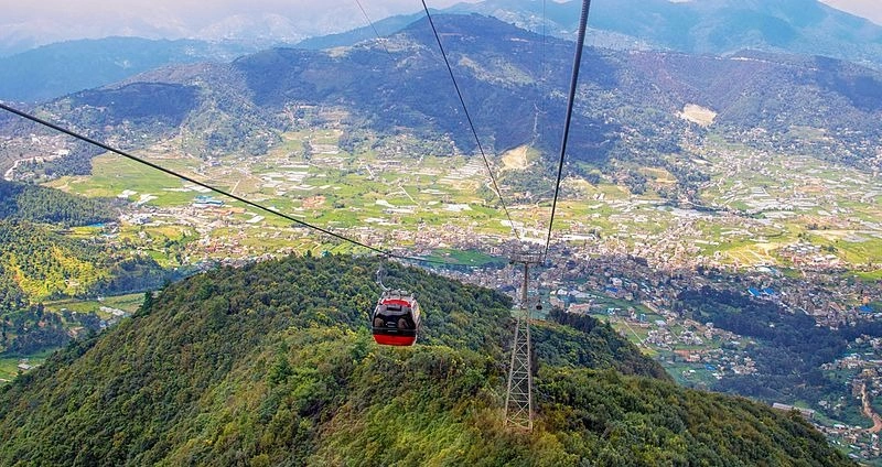
Kathmandu’s surrounding hills also provide some of the valley’s most rewarding Himalayan viewpoints and outdoor experiences. Nagarkot, Chandragiri Hills, Kakani, and Champadevi reveal different perspectives of the Himalayan range, while Jamacho Hill combines forest hiking, wildlife habitat, Buddhist heritage, and panoramic valley views. These destinations suit different travel styles, from relaxed nature walks and family visits to challenging day hikes, birdwatching trips, photography, and sunrise excursions. The guide compares all 10 natural places to visit in Kathmandu by location, elevation, accessibility, activities, trail difficulty, wildlife, scenery, and seasonal conditions to help travelers choose destinations that match their available time and interests.
1. Shivapuri Nagarjun National Park
Shivapuri Nagarjun National Park is Kathmandu's largest protected natural area, covering 159 square kilometers across the northern and northwestern rim of the valley. Established in 2002, it spans elevations from 1,350 meters to 2,732 meters at Shivapuri Peak. The park serves as the primary watershed for the Bagmati and Bishnumati rivers, which supply drinking water to approximately 2.5 million Kathmandu residents.
What Can You See and Do in Shivapuri Nagarjun National Park?
Shivapuri Nagarjun National Park offers 4 primary activity categories: wildlife observation, birdwatching, trekking to Shivapuri Peak, and pilgrimage to Bagdwar, the sacred source of the Bagmati River. The park records over 318 bird species, including the satyr tragopan, spiny babbler (Nepal's only endemic bird), and Himalayan monal. Leopards, Himalayan black bears, and barking deer inhabit the forest interior.
The Shivapuri Peak trail covers 14 kilometers round-trip from Budhanilkantha Gate. Most trekkers complete it in 6 to 7 hours. The Bagdwar trail branches off from the main ridge route and descends 2 kilometers to the spring that feeds the Bagmati River, a site of significant Hindu and Buddhist importance.
The Nagarjun section, in the park's western zone, contains a 3-kilometer forest trail with a watchtower that provides elevated views across the valley canopy. This section receives far fewer visitors than the Shivapuri side, making it the better choice for quieter wildlife observation.
What most visitors overlook: The park charges a standardized entry fee regardless of which gate you use, currently set at NPR 600 for SAARC nationals and NPR 1,000 for other international visitors (plus 13% VAT). Arriving at Budhanilkantha Gate before 7:00 AM places you on the trail before the morning mist burns off; the 90-minute window between 6:30 AM and 8:00 AM produces the highest bird activity.
When Is the Best Time to Visit Shivapuri Nagarjun National Park?
The 2 optimal seasons for Shivapuri Nagarjun are October–November and March–April. October and November deliver clear post-monsoon skies, dry trails, and peak migratory bird presence. March and April bring rhododendron bloom at mid-elevations (1,800–2,200 meters), along with high bird breeding activity. Temperature ranges during these windows stay between 8°C and 22°C.
Avoid the June–August monsoon window. Leeches colonize the lower trails from late June onward, and cloud cover eliminates Himalayan views from the summit zone. Experienced trekkers who visit during December and January encounter frozen ground above 2,400 meters but gain completely empty trails and extraordinary atmospheric clarity.
2. Phulchowki
Phulchowki Hill stands at 2,791 meters, the highest peak encircling Kathmandu Valley. Located 25 kilometers southeast of Thamel, it functions as a protected forest reserve recognized by BirdLife International as an Important Bird Area. The hill contains one of the most accessible high-altitude forests in South Asia within a major metropolitan area.
What Can You Experience on a Phulchowki Visit?
Phulchowki delivers 3 core natural experiences: exceptional birdwatching across 320+ recorded species, seasonal rhododendron forests covering the upper 400 meters of trail, and 360-degree views of Kathmandu Valley and the Himalayan arc from Langtang to Everest. The hill records higher bird species density per square kilometer than any other site inside the valley.
The trail from Godawari village to the summit spans 6 kilometers with 800 meters of elevation gain. The route passes through oak, rhododendron, and magnolia forest before emerging at the communication tower summit. Nepal's national bird, the Himalayan monal (Danphe), appears regularly in the upper 500 meters between March and May.
Beyond birdwatching, Phulchowki contains 17 species of rhododendron, a count that exceeds any single site in Kathmandu district. The deep forest floor stays humid year-round, supporting a rich understory of ferns, orchids (67 recorded species), and mosses.
What most visitors overlook: Phulchowki does not have an official entry point or fee structure as of 2026. Vehicle access to the summit requires a jeep or high-clearance 4WD. The road becomes impassable for standard cars after the first 3 kilometers during monsoon. Birders achieve the best species counts by starting the ascent on foot at 5:30 AM from Godawari, well before vehicle noise disturbs the mid-canopy.
When Is the Best Time to Visit Phulchowki?
The optimal window for Phulchowki runs from mid-March through late April for rhododendrons and resident bird activity, and October through November for migratory species and clear summit views. During peak spring bloom, the upper 600 meters of trail turns deep crimson with Rhododendron arboreum, Nepal's national flower. Migratory species concentrations peak in the October–November post-monsoon period.
3. Sundarijal
Sundarijal sits 15 kilometers northeast of Kathmandu's Ring Road, at an elevation of 1,460 meters. The name translates to "beautiful water" in Nepali, a reference to the cascade and reservoir that have supplied Kathmandu with drinking water since the 1960s. The Sundarijal Reservoir holds a capacity of 3.4 million liters and remains fully operational.
What Can You See and Do Around Sundarijal?
Sundarijal offers 4 distinct natural attractions: a 30-meter waterfall accessible within 20 minutes of entry, a reservoir flanked by pine and rhododendron forest, the main entrance to Shivapuri Nagarjun National Park's eastern sector, and the trailhead for the Helambu Circuit trek. The waterfall produces the strongest flow between June and September from monsoon runoff.
The area's forest road runs along the water supply pipeline, a 4-kilometer route known locally as the Pipeline Trail. This flat walking path between Sundarijal and Mulkharka village passes through dense forest with consistent bird activity. Common sightings include rufous-bellied woodpecker, white-throated laughingthrush, and Nepal's endemic spiny babbler.
The Bagmati River originates 9 kilometers upstream inside the national park. Short walks of 1 to 2 kilometers from the park gate reach the first riparian forest sections, where river birding produces different species from the hill forest above.
What most visitors overlook: Sundarijal functions simultaneously as a day-trip destination and a serious trekking gateway. The Helambu Circuit, a 4- to 7-day trek, begins here and connects through Sermathang, Melamchi Ghyang, and Tarkeghyang villages before looping back toward Kathmandu. Most Kathmandu-based travelers treat Sundarijal as a 3-hour outing when it has the infrastructure to anchor a multi-day Himalayan experience.
How Can You Combine Sundarijal With a Short Hike?
The Pipeline Trail to Mulkharka delivers a rewarding 8-kilometer round-trip day hike from Sundarijal, gaining 300 meters of elevation through intact national park forest with minimal technical difficulty. The trail begins 200 meters past the main reservoir gate and follows the water supply pipeline through a canopy of oak and rhododendron.
From Mulkharka (elevation 1,895 meters), a secondary trail continues 4 kilometers to Chisapani, a popular ridge-top viewpoint at 2,215 meters offering direct sightlines to the Langtang range. Completing the Sundarijal–Mulkharka–Chisapani section as a full-day hike covers 16 kilometers and 755 meters of gain. Most fit hikers complete this in 6 to 7 hours.
4. Chandragiri Hills
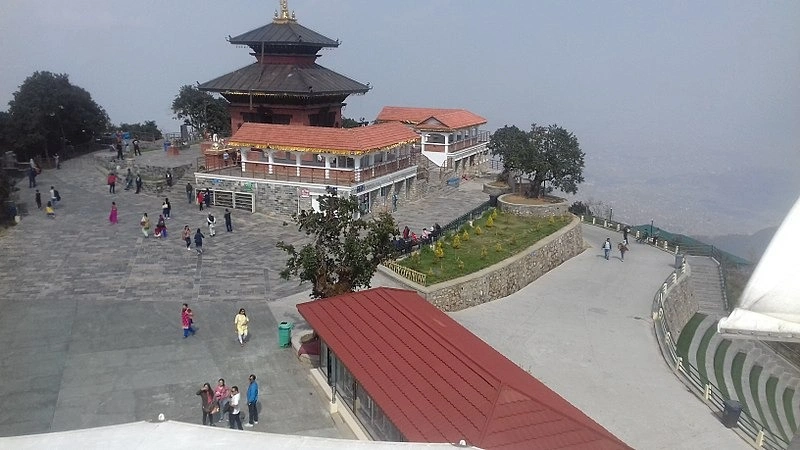
Chandragiri Hills rise to 2,551 meters on Kathmandu Valley's southwestern rim, directly above the Thankot area. The Chandragiri Cable Car, operational since 2016, carries visitors 2.3 kilometers from base to summit in 9 minutes. The cable car operates 360 gondola cabins across twin parallel lines and transports approximately 1,000 passengers per hour at peak capacity.
What Natural Attractions Can You Explore at Chandragiri Hills?
Chandragiri Hills contains 3 primary natural attraction layers: a Himalayan panorama spanning from Dhaulagiri (8,167 m) in the west to Everest (8,848 m) in the east, a 600-hectare protected forest with 4 marked hiking trails, and the Bhaleshwor Mahadev Temple set within alpine scrub forest. The summit ridge provides an unobstructed 200-kilometer east-west view across the Himalayan arc on clear days.
The forest below the summit holds populations of barking deer, red pandas (in the higher sections), and over 180 bird species. The mountain biking trail descending from the summit to Thankot covers 7.5 kilometers on a technical dirt path with 1,100 meters of descent, one of the steepest accessible descents near Kathmandu without requiring a long approach trek.
What most visitors overlook: Chandragiri receives disproportionately fewer visitors than Nagarkot despite offering a comparable Himalayan panorama. The cable car eliminates the need for a 3-hour ascent, making it the only major summit viewpoint in Kathmandu accessible to visitors who are not physically able to hike. The summit sits 400 meters higher than Nagarkot.
How Can You Enjoy the Views From Chandragiri Hills?
Chandragiri's summit delivers clear Himalayan views on 70% of October, November, and December mornings, the 3-month window with the highest atmospheric transparency in Kathmandu Valley. Positioning at the summit before 8:00 AM produces the sharpest mountain clarity before valley haze develops.
The western face of the ridge faces the Dakshinkali valley, offering an entirely different landscape than the Kathmandu city view on the eastern side. Sunset from the western observation deck between 5:00 PM and 6:30 PM (October–March) produces layered mountain silhouettes across the Ganesh Himal and Langtang ranges. This vantage point sees 60% fewer visitors than the main eastern viewpoint.
5. Nagarkot
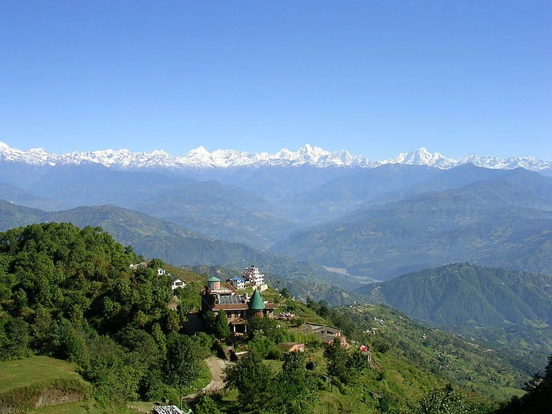
Nagarkot sits at 2,175 meters on Kathmandu Valley's eastern edge, 32 kilometers from the city center. It holds the distinction of being the most accessible overnight Himalayan viewpoint from Kathmandu, with direct bus service from Bhaktapur's Kamal Binayak stop. On clear mornings, 8 distinct Himalayan ranges are visible from the Nagarkot ridge, including the Everest massif, Langtang, Ganesh Himal, Manaslu, Annapurna range, Dhaulagiri, and Rolwaling.
What Natural Views and Experiences Does Nagarkot Offer?
Nagarkot delivers sunrise views over a 240-kilometer span of the Himalayan range from a single fixed ridge point, making it the broadest accessible mountain panorama within 35 kilometers of any South Asian capital city. The Everest group (8,848 m) appears as a distinctive pyramid 145 kilometers to the northeast on days with visibility above 60 kilometers.
Beyond sunrise viewing, Nagarkot connects to a 15-kilometer ridge trail running west to Changu Narayan, an ancient UNESCO World Heritage temple at 1,541 meters elevation. This downhill trail through terraced farmland and forest takes 4 to 5 hours and deposits walkers at Bhaktapur for transport back to Kathmandu. The route passes 3 distinct vegetation zones: subalpine shrub, mid-hill forest, and valley-edge agricultural terraces.
Nagarkot also sits at the edge of the Bhaktapur–Nala–Nagarkot cycling corridor, a 45-kilometer road circuit popular with Kathmandu-based cyclists seeking a managed elevation challenge without technical trail skills.
When Is the Best Time to Visit Nagarkot?
The 3-month period from October through December produces the clearest Nagarkot conditions, with mountain visibility exceeding 100 kilometers on 65–80% of mornings. Morning temperature at the ridge ranges from 4°C (December) to 14°C (October), requiring a warm layer even during autumn visits.
March and April deliver the second-best window, with warming temperatures and good clarity before pre-monsoon haze builds in May. June through September monsoon clouds consistently obscure Himalayan views, though the valley below turns intensely green during this period, a different but legitimate natural experience. Avoid the haze-heavy May and late February windows.
6. Jamacho Hill
Jamacho Hill reaches 2,128 meters within the Nagarjun section of Shivapuri Nagarjun National Park, 8 kilometers northwest of Kathmandu's Ring Road. The summit holds a Tibetan Buddhist gompa, the Jamacho Gumba, founded in the 17th century by the Nyingma tradition. The combination of forest trail, wildlife habitat, and active religious site makes Jamacho a multi-layered destination.
What Can You See During a Jamacho Hill Hike?
The Jamacho Hill trail passes through 4 distinct forest types, sal forest, mixed broadleaf, rhododendron-oak, and subalpine shrub, producing consistent wildlife and birdwatching opportunities across the 500-meter elevation gain from the Nagarjun Gate. Leopards use the forest regularly; pug marks appear on the muddy upper trail sections during the November–January dry season with high frequency.
From the Jamacho Gumba summit, the valley panorama spans Kathmandu city to the south and the Langtang Himal (7,246 m) to the north. The panorama includes the white stupa of Boudhanath, a UNESCO World Heritage Site, visible as a distinctive dome 6 kilometers to the southeast. The monastery itself remains open to visitors and maintains an active prayer hall.
What most visitors overlook: Jamacho Hill lies entirely within the paid Nagarjun park zone. Entry requires the standard national park fee (NPR 600 for SAARC nationals and NPR 1,000 for other international visitors, plus 13% VAT) paid at the main Nagarjun Gate, 3 kilometers past Balaju. The gate does not consistently accept digital payments as of 2026; bringing cash is essential. Motorbikes are permitted on the forest road partway up, but the final 800 meters to the summit requires foot travel on a narrow stepped path.
How Difficult Is the Jamacho Hill Hike?
The Jamacho Hill hike covers 6 kilometers round-trip with 460 meters of elevation gain, rated at moderate difficulty, and takes 3 to 4 hours for the average hiker. The first 2 kilometers from the gate follow a paved forest road with a gentle gradient. The upper trail switches to compacted earth steps with exposed root sections.
Hikers with normal cardiovascular fitness complete the ascent in 90 to 120 minutes. The descent takes 60 to 75 minutes. Trail conditions deteriorate significantly during monsoon months (June–September), when the clay soil becomes slick and leech density increases substantially. October through April produces the most stable and pleasant trail conditions for this hike.
7. Taudaha Lake
Taudaha Lake occupies a natural glacial depression 5 kilometers south of Kathmandu, at an elevation of 1,330 meters near Kirtipur. The lake covers approximately 2 hectares and reaches a maximum depth of 6 meters. According to local legend, the Buddhist deity Manjushree drained Kathmandu Valley from its ancient lake state, and Taudaha represents the last water pocket retained for the Nagas (serpent deities) to inhabit.
What Wildlife and Scenery Can You Experience at Taudaha Lake?
Taudaha Lake hosts 3 categories of natural attraction: winter migratory waterfowl (28 recorded species), resident freshwater birds year-round, and a peaceful wetland ecosystem set against a backdrop of valley farmland and distant Himalayan peaks. The lake records bar-headed goose, mallard, common teal, gadwall, and ferruginous duck during the November–February winter migration period.
The surrounding wetland margin supports populations of purple swamphen, pheasant-tailed jacana, and little grebe throughout the year. Marsh frogs become vocal from April through October. The lake's northern shore offers a 1.5-kilometer walking path that circumnavigates the water body, taking approximately 30 minutes at a leisurely pace.
Taudaha sits within a larger agricultural landscape of terraced fields. The juxtaposition of the still lake surface, the farming community of Kirtipur directly west, and the Himalayan backdrop to the north creates a composition that surprises most visitors expecting a more remote wilderness.
What most visitors overlook: Taudaha has no admission fee. The lake is accessible by bicycle or motorcycle from Kathmandu's Ring Road in 20 minutes. Plastic disposal in the lake margin remains a documented problem, responsible visitors bring their own waste out. The best photographic light occurs between 6:30 AM and 8:00 AM, when low-angle morning light illuminates both the water surface and background mountains simultaneously.
When Is the Best Time to Visit Taudaha Lake?
November through February delivers Taudaha's peak wildlife experience, with migratory waterfowl populations reaching 500–800 individual birds across 28 species during peak winter concentration weeks. The December and January period produces the highest species diversity. Water temperature drops to 9–12°C during this window, keeping the lake clear and mirror-calm on windless mornings.
March through May provides good resident bird activity but no migratory species. The monsoon period floods the surrounding wetland margin and reduces walkable access around the lake. September marks the beginning of the migratory return cycle, with early-arriving species appearing by mid-October.
8. Godawari Botanical Garden
Godawari Botanical Garden, formally the National Botanical Garden of Nepal, occupies 82 hectares at the base of Phulchowki Hill, 26 kilometers south of Kathmandu center at 1,524 meters elevation. Established in 1962 under the Department of Plant Resources, it holds the national plant collection: over 1,000 documented plant species, including 375 trees and shrubs, 183 orchid species, and 45 fern species.
What Plants and Natural Attractions Can You See at Godawari?
Godawari Botanical Garden contains 7 distinct themed zones: the rock garden, orchid house, cactus house, water lily pond, bamboo collection, native tree arboretum, and wild garden, each representing a different plant community of Nepal. The orchid house maintains 183 live species from Nepal's subtropical, temperate, and alpine zones under controlled humidity.
The rock garden covers 3 hectares and replicates Himalayan alpine conditions with documented alpine plant species arranged by elevation origin. The water lily pond hosts 11 varieties of Nymphaea and supports a resident population of spot-billed ducks and bronze-winged jacanas. The native tree arboretum contains labeled specimens of 120 tree species found across Nepal's diverse climatic zones.
Outside the formal collection, the garden's eastern margin borders the Godawari stream, a fast-moving tributary that attracts plumbeous water redstart, little forktail, and white-capped redstart along its rocky banks throughout the year.
Why Is Godawari Botanical Garden Suitable for a Relaxed Visit?
Godawari Botanical Garden suits visitors seeking nature immersion without physical exertion, it operates on flat terrain, features 5 kilometers of paved internal paths, and maintains visitor facilities including a café, labeled specimen maps, and covered rest areas. Entry costs NPR 50 for Nepali nationals and NPR 250 for international visitors (2026 rates).
The garden opens daily from 9:00 AM to 5:00 PM (closing at 4:00 PM during the winter months) and remains open seven days a week, including public holidays. Morning light from 10:00 AM to noon illuminates the orchid house best. The Sunday crowd peaks between 11:00 AM and 2:00 PM; arriving at 10:00 AM on weekdays gives near-private access to all zones.
Families with children benefit from the garden's combination of educational labels, open lawns, and shaded pathways. The rock garden section contains interpretive signage explaining altitude-specific plant adaptations, a feature absent from most of Kathmandu's other natural sites.
9. Champadevi Hill
Champadevi Hill rises to 2,278 meters on Kathmandu Valley's southwestern fringe, connected to the Chandragiri ridge system. The hill takes its name from a revered Hindu shrine at the summit, the Champadevi Temple, which serves as both a pilgrimage destination and a natural viewpoint. The trail begins at Pharping village, 20 kilometers south of Kathmandu.
What Can You Experience on the Champadevi Hill Trail?
The Champadevi Hill trail delivers 4 compounding experiences: forest hiking through rhododendron and pine cover, passage through 2 active cave monastery complexes at Pharping, summit pilgrimage to the Champadevi Temple, and direct ridge-line views of Kathmandu Valley and the Langtang and Ganesh Himal groups. The trail from Pharping covers 5 kilometers one-way with 700 meters of elevation gain.
Pharping village, the trail's base, contains 2 significant Buddhist sacred sites: the Yanglesho Cave, where Padmasambhava (Guru Rinpoche) attained realization in the 8th century, and the Dakshinkali Temple complex 2 kilometers west. Many visitors combine the Champadevi hike with visits to both sites in a single day.
The trail passes through rhododendron forest between 1,800 and 2,100 meters. April produces the densest bloom concentration on this route. A connecting ridge path continues 8 kilometers northwest from Champadevi summit to Chandragiri, allowing experienced hikers to complete a full southwest valley rim traverse in 7 to 8 hours.
What most visitors overlook: Champadevi offers the least-crowded major ridge hike in Kathmandu Valley. Weekend mornings on this trail rarely exceed 30 hikers, compared to 300+ on Nagarkot. The summit shrine operates as an active worship site; respectful dress, shoulders covered, footwear removable, is required at the temple platform.
What Views Can You See From Champadevi Hill?
Champadevi's summit delivers a dual panorama: Kathmandu Valley spreads across the entire northern horizon at 1,400 meters below, while the Himalayan chain from Annapurna South (7,219 m) to Ganesh Himal (7,429 m) frames the view above the northern valley rim. On the clearest October and November mornings, Mount Everest's summit (8,848 m) appears as a black triangle above the valley skyline, 157 kilometers to the northeast.
The valley view from Champadevi reveals a geography rarely apparent at ground level: the oval basin shape of ancient Lake Kathmandu, the three distinct city clusters of Kathmandu, Patan, and Bhaktapur separated by the Bagmati River system, and the Ring Road's circular trace around the urban core.
10. Kakani
Kakani stands at 2,073 meters on Kathmandu Valley's northwestern rim, 28 kilometers from the city center via Balaju. Compared to Nagarkot, Kakani receives 70% fewer visitors despite offering a comparable Himalayan panorama with the added advantage of open meadow landscapes, strawberry cultivation terraces, and direct sightlines toward the Ganesh Himal range. The Kakani Watershed Forest covers 4,600 hectares surrounding the viewpoint area.
What Natural Attractions Can You Explore in Kakani?
Kakani offers 4 natural attractions: Himalayan panorama viewpoints dominated by Ganesh Himal (7,429 m) and Langtang Lirung (7,246 m), a meadow landscape used for strawberry cultivation at altitude, watershed forest with 200+ recorded bird species, and a quiet ridgeline walking environment entirely free of cable cars or commercial infrastructure. The Ganesh Himal range appears exceptionally close from Kakani, its glaciated flanks visible without optical aids on clear mornings.
The Kakani viewpoint area contains an open government rest park with lawn terraces facing north toward the Himalaya. Walking paths extend 3 kilometers along the ridge to the Kakani Hill Resort area and beyond to a communications tower with the highest vantage point at 2,175 meters. The strawberry farms operating between 1,800 and 2,073 meters produce fruit from late March through May, a period when farm stalls along the access road sell fresh strawberries and strawberry preserves directly to visitors.
What most visitors overlook: Kakani holds a poignant memorial park dedicated to the victims of the 1992 Thai Airways Flight 311 crash, alongside a mountaineers' memorial. These sites sit within a short walk of the main viewpoint and provide a historically and humanly resonant complement to the natural experience. The park is open to the public daily at no charge.
When Is the Best Time to Visit Kakani?
October, November, and December deliver Kakani's clearest Himalayan views, with the Ganesh Himal range visible from the meadow viewpoints on 75% of mornings during this 3-month window. Daytime temperatures range from 7°C (December) to 17°C (October), requiring a mid-layer jacket for morning viewpoint sessions.
March through April provides the second-best clarity window, combined with strawberry season along the approach road. The monsoon period (June–September) blankets the Himalayan views under cloud but produces intensely green meadow and forest conditions. Kakani's meadow landscape turns photogenic during the monsoon in a way that rocky ridge viewpoints like Nagarkot do not.
How Can You Explore Kathmandu's Natural Places With Nepal Intrepid Treks?
Reaching Kathmandu's natural sites without local knowledge produces avoidable friction, incorrect trail access points, missed entry fee structures, vehicle limitations on mountain roads, and permit requirements that change seasonally. Nepal Intrepid Treks resolves each of these barriers through structured day-trip and multi-day itineraries covering all 10 natural sites in this guide.
Can Nepal Intrepid Treks Help You Explore Kathmandu's Natural Places?
Nepal Intrepid Treks designs Kathmandu Valley natural itineraries across 3 service levels: guided day trips to individual sites such as Phulchowki, Sundarijal, or Kakani; multi-day valley circuits combining 4 to 6 natural sites with overnight accommodation; and custom private arrangements for specialized interests including birdwatching, photography, or family-accessible visits.
The team provides licensed guides with verifiable expertise in Kathmandu Valley natural history, government-registered vehicles with 4WD capacity for sites requiring forest road access, and pre-arranged national park entry documentation. For birdwatchers specifically, Nepal Intrepid Treks pairs clients with ornithology-trained guides who carry updated species checklists for each site, a service that elevates casual wildlife observation to systematic species documentation.
Groups visiting Phulchowki or Shivapuri Nagarjun benefit from guide knowledge of seasonal trail conditions, current leopard activity zones, and the exact forest sections producing the highest bird encounter rates. This converts a 3-hour visit into a structured natural history experience rather than an unguided forest walk.
Contact Nepal Intrepid Treks to discuss which combination of natural sites matches your available time, physical fitness level, and specific interests, whether that is a sunrise Nagarkot visit, a Phulchowki birdwatching morning, or a full southwest valley rim traverse from Pharping to Champadevi and Chandragiri.
What Are the Key Takeaways About the Best Natural Places to Visit in Kathmandu?
Kathmandu Valley's 10 natural destinations span elevations from 1,330 meters (Taudaha Lake) to 2,791 meters (Phulchowki), creating a diverse altitudinal range within 32 kilometers of the city center. Each site delivers a specific type of natural experience rather than a generic mountain visit.
The 5 highest-value sites based on experience density are:
Shivapuri Nagarjun National Park: Greatest ecological breadth, with 318 bird species, large mammal populations, and the Bagmati River source trek
Phulchowki: Highest elevation, densest rhododendron concentration (17 species), and the strongest birdwatching site in the valley
Nagarkot: Broadest Himalayan panorama (240-kilometer arc) with direct public transport access
Chandragiri Hills: Only cable car-served summit, accessible to visitors without hiking capacity, with views 400 meters higher than Nagarkot
Sundarijal: Most versatile site, functioning as a day trip, short hike, or multi-day trek gateway simultaneously
Optimal visiting windows by season: October and November serve every site on this list simultaneously and represent the single best period for first-time visitors targeting maximum natural value per travel day. March and April follow as the spring alternative, with rhododendrons and birds at their peak.
Kathmandu's natural landscape remains significantly underutilized relative to its ecological richness, most visitors spend one or two days at a single viewpoint site when the valley holds 10 distinct ecosystems within a 35-kilometer radius. Planning a visit across 3 to 5 sites, guided by an organization with verified local expertise, produces a natural travel experience that rivals dedicated trekking regions while remaining fully accessible from a single Kathmandu base.
.avif&w=1920&q=75)