Nepal contains 5,358 recorded lakes, forming a dense and diverse freshwater network across the Himalaya, mid-hills, and Terai lowlands, based on the national inventory published by Bhuju et al. (2010) in the Nepal Journal of Science and Technology. This authoritative lake count in Nepal was compiled using 1:25,000 topographic maps under the National Lake Strategic Plan, involving institutions such as the Nepal Academy of Science and Technology, National Trust for Nature Conservation, and Tribhuvan University. Nepal’s lakes range from high-altitude glacial systems like Tilicho and Imja Tsho to lowland oxbow lakes formed by dynamic river systems such as the Koshi and Narayani, making the country one of the most freshwater-rich landscapes in South Asia.
This national lake system reflects strong geological and ecological diversity, with 2,323 glacial lakes in the Himalayas, 2,712 floodplain lakes in the Terai, and smaller tectonic and landslide-dammed lakes in the mid-hills. Lakes such as Rara, Phewa, and Shey Phoksundo represent Nepal’s largest, deepest, and most visited water bodies, while sacred sites like Gosainkunda and Ramsar-listed wetlands highlight their cultural and conservation value. Beyond their count, Nepal’s lakes support biodiversity, tourism, irrigation, and religious practices, while also facing growing threats from pollution, encroachment, and glacial lake outburst floods (GLOFs). This guide breaks down the exact number of lakes in Nepal, how they are classified and distributed, and why they matter across ecological, cultural, and economic dimensions.
Which Lake Count Is Most Often Cited for Nepal?
The most cited lake count for Nepal is 5,358, drawn from the 2010 map-based inventory by Bhuju et al., published in Nepal Journal of Science and Technology, Volume 11. This figure appears across government databases, academic literature, and conservation planning documents as the authoritative baseline.
The National Lake Conservation Development Committee (NLCDC) maintains this inventory across 4 partner institutions: the Nepal Academy of Science and Technology (NAST), National Trust for Nature Conservation (NTNC), Tribhuvan University – Central Department of Environmental Science (TU-CDES), and the Central Department of Statistics of the Government of Nepal. Each institution holds a complete copy of the database.
Which Inventory Is Usually Quoted in Lake-Count Articles?
The Bhuju et al. (2010) inventory is the reference standard. It used topographic sheets published between 1992 and 2001 rather than district maps, because district maps missed thousands of lakes, the topographic sheets revealed 5,358 lakes while district maps identified only 278.
The National Lake Conservation Development Committee (NLCDC) 2019 literature records a complementary count: 2,323 glacial lakes and 5,358 tectonic and oxbow lakes, reflecting different classification categories within the same national dataset.
Why Do Different Sources Report Different Totals?
Different sources report different totals because lake classification, map resolution, and survey methodology vary across inventories. 3 core factors produce diverging counts:
Definition thresholds: Some inventories exclude water bodies below a minimum surface area, while others count seasonal ponds and wetland pools
Map resolution: District-level maps omitted 21 districts entirely; topographic sheet analysis revealed lakes absent from those maps
Satellite era updates: Post-2010 remote sensing identifies glacial lakes forming and draining within weeks, adding temporary water bodies older surveys missed
The most conservative published figure is 5,358. Some travel sources round this to 5,300 or cite "over 5,000" as a general approximation.
How Are Lakes Counted and Defined in Nepal?
Lakes in Nepal are counted by identifying closed water bodies on topographic sheets, coded by district with an alpha-numerical system, and recorded with name, location, altitude, and grid coordinates. The 2010 Bhuju et al. inventory defined this methodology and remains the national standard.
What Counts as a Lake Instead of a Pond or Wetland?
The Bhuju inventory counted any closed water body indicated on published 1:25,000 topographic sheets as a lake, regardless of size. This inclusive definition captured both large lakes like Rara (10.4 sq km) and small features under 1 hectare. Nepal's lake database does not apply a universal minimum-size threshold, distinguishing it from inventories in countries that enforce a 1-hectare or 10-hectare cutoff.
Wetlands with open drainage, such as seasonal floodplains connected to rivers, fall outside the inventory. Oxbow lakes qualify because they represent closed, formerly riverine water bodies now cut off from active channels.
How Do Maps, Surveys, and Satellite Data Change the Count?
Topographic sheets, field surveys, and satellite imagery each reveal different subsets of Nepal's lake total. Topographic sheets (1992–2001) identified 5,358 lakes. District maps from the same era captured only 278, a 94.8% undercount. Field surveillance by 121 researchers added names and validation to 472 lakes listed on topographic sheets. Post-2010 satellite monitoring by the International Centre for Integrated Mountain Development (ICIMOD) documents new glacial lakes forming annually as glaciers retreat, meaning the true count rises year on year.
Where Are Most Lakes Located in Nepal?
Nepal's lakes concentrate in 2 altitude zones: the Terai lowlands below 500 meters, holding 2,712 lakes (51%), and the Himalayan highlands above 3,000 meters, holding 2,227 lakes (42%). Only 419 lakes (7%) occupy the mid-hill zone between 500 and 2,999 meters.
Why Are Many Lakes Found in the Terai and High Himalayas?
The Terai accumulates oxbow lakes from braided river systems, while the high Himalayas accumulate glacial lakes from retreating glaciers, 2 geologically productive lake-forming environments. The mid-hill zone, shaped by erosional topography rather than depositional or glacial processes, generates far fewer closed water bodies.
Terai rivers such as the Koshi, Narayani, and Karnali deposit sediment across broad floodplains, regularly shifting channels and cutting off meanders. Each abandoned meander becomes an oxbow lake. The Himalayan zone produces glacial tarns, moraine-dammed lakes, and proglacial lakes as ice retreats under warming temperatures.
How Does Altitude Shape Lake Distribution Across Nepal?
Altitude governs lake type, formation process, and ecological character across 3 distinct elevation bands:
Below 500m (Terai): 2,712 lakes, predominantly oxbow and floodplain lakes; warm water; high biological productivity; seasonal flood dynamics
500–2,999m (Mid-Hills): 419 lakes; tectonic and landslide-dammed origin; moderate elevation; Phewa Lake (742m) and Begnas Lake are representative
Above 3,000m (Himalaya): 2,227 lakes; glacial origin predominates; cold, oligotrophic waters; limited aquatic life above 4,500m
Which Regions and Districts Have the Most Lakes?
8 districts hold the highest concentration of lakes: Humla (381), Taplejung (380), Kapilbastu (351), Solukhumbu (339), Rupandehi (289), Banke (243), Dhanusa (230), and Dolpa (210), according to the Bhuju et al. (2010) inventory.
Which Districts Appear Most Often in Lake Inventories?
The following table presents the 8 highest-ranked districts by lake count, drawn from the 2010 national map-based inventory.
District | Province | Lake Count | Primary Zone |
Humla | Karnali | 381 | Mountain |
Taplejung | Koshi | 380 | Mountain |
Kapilbastu | Lumbini | 351 | Terai |
Solukhumbu | Koshi | 339 | Mountain/Hill |
Rupandehi | Lumbini | 289 | Terai |
Banke | Lumbini | 243 | Terai |
Dhanusa | Madhesh | 230 | Terai |
Dolpa | Karnali | 210 | Mountain |
74 of Nepal's 75 former districts contain lakes. Okhaldhunga appears on district maps as having 2 lakes, but topographic sheets confirm none.
What Do Regional Lake Patterns Reveal About Nepal?
Regional lake patterns reveal that western Nepal (Sudurpaschim and Karnali Provinces) holds 1,271 lakes (23.72% of the national total), making it the highest concentration of any 2-province block. Bagmati Province records 222 lakes, with 95% in the hill zone, predominantly in Lalitpur (97 lakes), Kathmandu (58 lakes), and Bhaktapur (52 lakes). Lumbini Province holds 97 lakes, with 92% in the Terai, concentrated in Rupandehi (28), Kapilvastu (24), and Parasi (21).
What Types of Lakes Are Found in Nepal?
Nepal contains 4 primary lake types: glacial lakes, alpine tectonic lakes, oxbow lakes, and landslide-dammed lakes, each formed by distinct geological and hydrological processes.
What Are Glacial, Alpine, Oxbow, and Tectonic Lakes?
Glacial lakes: Water bodies formed by glacier retreat, meltwater accumulation behind moraine dams, or ice-carved bedrock basins. Nepal contains 2,323 glacial lakes. Examples: Tilicho (4,919m), Imja Tsho, Tsho Rolpa.
Alpine tectonic lakes: Lakes occupying tectonic depressions or fault-related basins at high elevation. Rara Lake (3,200m, 10.4 sq km) occupies a tectonic basin in the Karnali uplift zone.
Oxbow lakes: Crescent-shaped lakes formed when river meanders are cut off from the main channel. Bishazari Lake (Chitwan, 3,200 ha) and Ghodaghodi Lake (Kailali, 2,563 ha) are Nepal's most significant oxbow systems.
Landslide-dammed lakes: Temporary or permanent lakes formed when slope failures block river valleys. These occur across Nepal's active seismic and erosion zones.
Which Famous Lakes Represent These Lake Types?
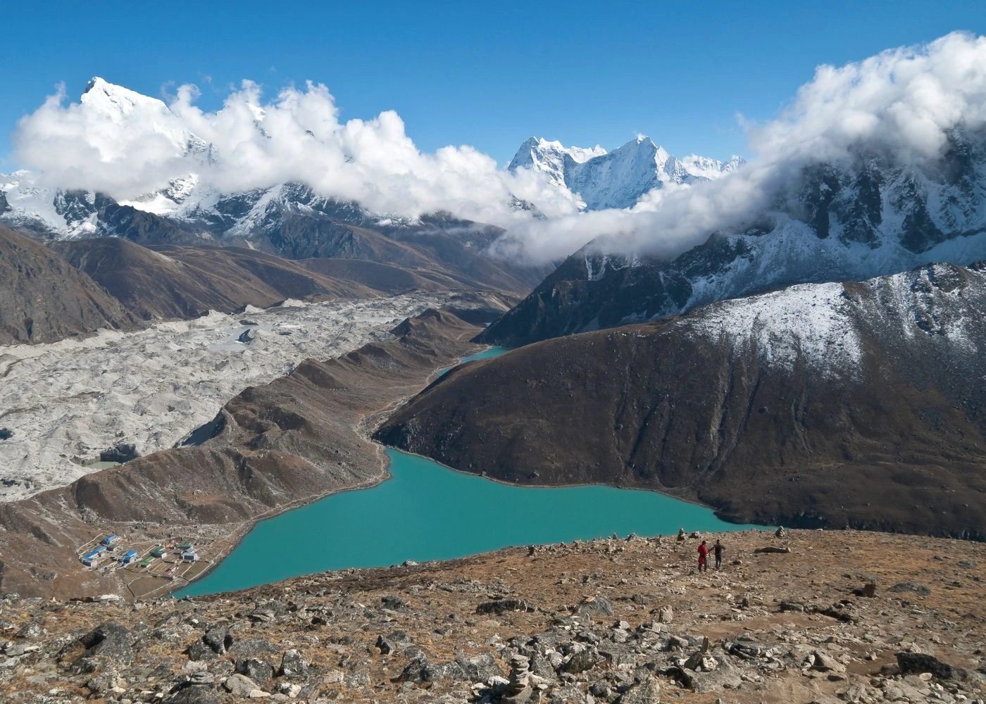
Glacial type: Tilicho Lake (Manang, 4,919m, 4.8 sq km), Gokyo Lakes (Solukhumbu, 4,700–5,000m)
Alpine tectonic: Rara Lake (Karnali, 3,200m, 10.4 sq km), Shey Phoksundo (Dolpa, 3,611m, 4.85 sq km)
Oxbow: Bishazari Lake (Chitwan, 286m), Ghodaghodi Lake (Kailali, 205m)
Sacred alpine: Gosainkunda (Rasuwa, 4,380m), Panch Pokhari (Sindhupalchowk, 4,100m)
Which Lakes in Nepal Are the Most Well Known?
Nepal's 5 most widely recognized lakes are Rara, Phewa, Tilicho, Shey Phoksundo, and Gosainkunda, distinguished by superlative status, accessibility, and cultural or conservation designation.
Why Are Rara, Phewa, Tilicho, and Phoksundo Notable?
Rara Lake is Nepal's largest freshwater lake at 10.4 sq km, located in Karnali Province at 3,200m. It drains into the Mugu Karnali River, holds oligotrophic water chemistry, and displays color shifts from blue to crimson to purple across a single day. The Rara National Park surrounding it became a Ramsar site in 2007.
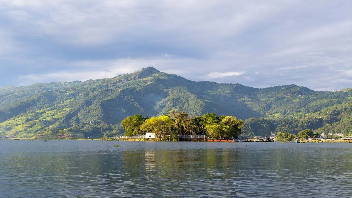
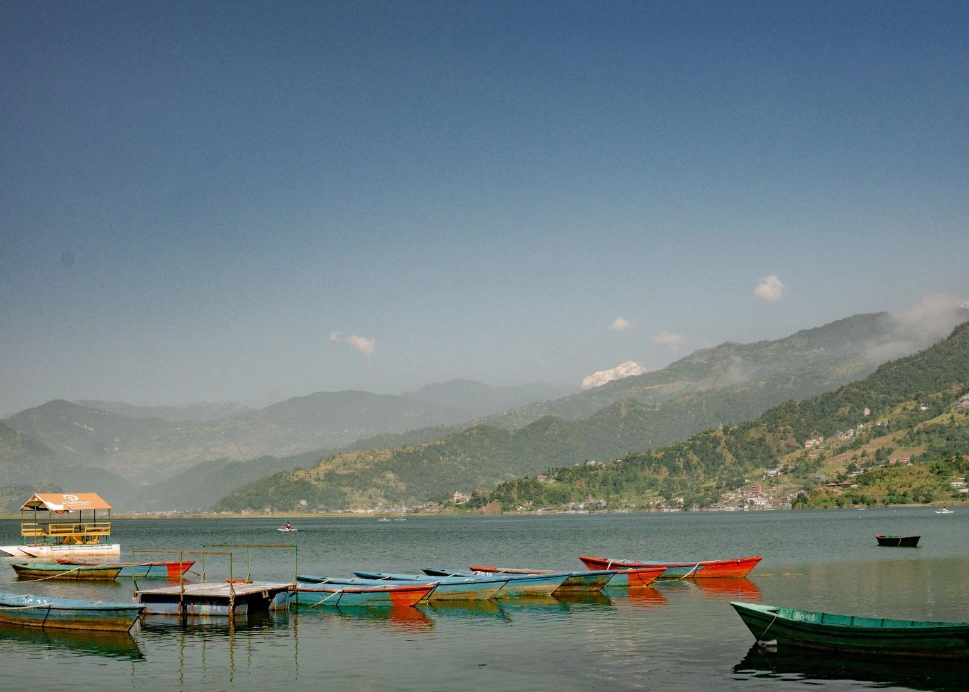
Phewa Lake is Nepal's second-largest lake at 4.43 sq km, situated in Pokhara at 742m. The Tal Barahi Temple sits on a small island at its center. The lake reflects Machhapuchhre (6,993m) and the Annapurna range (8,091m) on clear days, making it Nepal's most photographed lake.
Tilicho Lake sits at 4,919m in Manang District, Gandaki Province, the highest lake in Nepal and one of the highest lakes in the world. Its 4.8 sq km surface holds no aquatic organisms due to extreme altitude. It is the primary side-trip destination on the Annapurna Circuit trek.
Shey Phoksundo Lake occupies 4.85 sq km in Dolpa District at 3,611m. Its maximum depth reaches 136.2m, making it Nepal's deepest lake. The turquoise water colour results from the lack of aquatic organisms in its oligotrophic chemistry, conditions shared with Rara. 20 Buddhist stupas line its southern shore.
Which Lakes Are Sacred, Scenic, or Protected?
6 lakes in Nepal hold Ramsar Wetland of International Importance status: Gosainkunda (designated 2007), Rara Lake (2007), Shey Phoksundo (2007), Bishazari Tal (2003), Ghodaghodi Tal (2003), and the Gokyo Lakes system. Gosainkunda (4,380m, 4.0 sq km) in Langtang National Park is surrounded by 108 associated lakes and serves as a pilgrimage destination for Hindus during Janai Purnima festival, attracting thousands of devotees annually from Nepal and India.
Why Do Nepal's Lakes Matter So Much?
Nepal's lakes matter because they supply freshwater, sustain biodiversity, anchor tourism, and hold cultural and religious significance across all 3 ecological zones. Nepal ranks as the world's second-richest country in freshwater resources, with over 6,000 rivers and 5,358 recorded lakes.
How Do Lakes Support Biodiversity, Culture, and Tourism?
Biodiversity: Ghodaghodi Lake Complex (Kailali) provides habitat for 26 mugger crocodiles, multiple critically endangered mammal species, and qualifies as an Important Bird Area (IBA). Rupa Lake in Pokhara Valley supports 36 waterbird species. The Gokyo Lakes, designated as a Ramsar site, sustain the world's highest freshwater lake system within Sagarmatha National Park.
Culture: Lakes carry active ritual significance. Gosainkunda, referenced in Bhagavata Purana, Vishnu Purana, Ramayana, and Mahabharata, attracts pilgrims who believe Lord Shiva created the lake. Panch Pokhari (5 sacred lakes, Sindhupalchowk) draws Hindus during Janai Purnima. Shey Phoksundo is sacred to the Bon Buddhist tradition.
Tourism: Phewa Lake drives Pokhara's lakeside tourism economy, generating revenue across boating, hospitality, and adventure sectors. Trekking circuits connecting multiple lakes, the Annapurna Circuit (Tilicho), Everest Base Camp route (Gokyo), Rara trekking route, and Dolpa circuit (Phoksundo), represent Nepal's highest-traffic trekking corridors.
Why Are Lakes Important to Wetlands and Local Livelihoods?
Nepal's Terai lakes and wetland systems support agriculture through irrigation, fishing for local protein supply, and a green corridor between lowland plains and Siwalik hills. Bishazari Lake, covering 3,200 ha in Chitwan's buffer zone, provides habitat for Bengal tiger, one-horned rhino, smooth-coated otter, and sloth bear, species whose conservation directly supports Nepal's USD 2+ billion annual tourism sector. The Tharu community of Kailali District celebrates "Agan Panchami" at Ghodaghodi Lake, sustaining an unbroken cultural-ecological relationship with the wetland.
What Threats Are Nepal's Lakes Facing Today?
Nepal's lakes face 3 primary threat categories: pollution and eutrophication in accessible mid-hill and valley lakes, physical encroachment reducing surface area, and glacial lake outburst flood (GLOF) risk at high-altitude lakes under accelerating glacier retreat.
How Do Pollution and Encroachment Damage Lakes?
Phewa Lake in Pokhara has lost surface area continuously since the 1960s due to sedimentation and urban encroachment. From 1962 to 2024, the lake lost approximately 5.62 sq km of surface area, driven by sediment deposition, untreated sewage discharge, urban runoff, and invasive aquatic weeds that degrade water quality and reduce dissolved oxygen. Similar encroachment patterns affect Begnas Lake, Rupa Lake, and Taudaha Lake near Kathmandu.
Why Are Glacial Lake Risks Receiving More Attention?
47 glacial lakes in Nepal are classified as potentially dangerous, with 4, Thulagi, Lower Barun, Lumding Tsho, and Hongu 2, designated as urgent priority cases by the UNDP and Green Climate Fund. Nepal has recorded 26 glacial lake outburst flood (GLOF) events since the 1970s. A single GLOF event at Dig Tsho in 1985 caused USD 3 million in damage. Projected worst-case economic losses for Imja, Tsho Rolpa, and Thulagi lake outbursts reach USD 415 million per event, with hydropower project losses estimated at USD 8.98 billion for Imja Tsho alone.
In August 2024, Thyanbo Lake (0.05 sq km) in Solukhumbu burst and destroyed infrastructure in Thame village, displacing 135 residents. In July 2025, a newly formed supraglacial lake in Rasuwagadhi, invisible before March 2025, burst and killed at least 9 people, swept away a major Nepal-China border bridge, and sent floodwaters more than 100km downstream. According to ICIMOD remote sensing analyst Finu Shrestha, small and short-lived glacial lakes are now proving more hazardous than previously recognized. The Green Climate Fund approved USD 36 million in financing for Nepal's GLOF risk reduction project, covering early warning systems, lake-lowering interventions, and eco-engineering defenses at the 4 priority lakes.
How Can This Lake Count Guide a Nepal Lake Trip?
Nepal's 5,358 lakes span 3 ecological zones, 74 districts, and 7 provinces, enabling lake-focused itineraries at every altitude and accessibility level, from Phewa Lake's lakeside promenade in Pokhara to the 3-day trek to Rara Lake in Karnali Province.
The 5 most accessible high-impact lakes for travellers are:
Phewa Lake (Pokhara, 742m): reachable by direct flight from Kathmandu; boat hire available year-round
Gosainkunda (Rasuwa, 4,380m): 4–5 day trek from Dhunche; best accessed April–June and September–November
Tilicho Lake (Manang, 4,919m): side trek on the Annapurna Circuit; acclimatization at Manang required
Shey Phoksundo (Dolpa, 3,611m): fly Kathmandu–Nepalgunj–Juphal, then 3-day trek
Rara Lake (Karnali, 3,200m): fly Kathmandu–Nepalgunj–Jumla, then 3-hour walk
Can a Nepal Travel Service Help You Visit Key Lakes?
A licensed Nepal trekking operator handles permit acquisition, route planning, accommodation logistics, and altitude acclimatization scheduling for all 5 lake destinations. Required permits vary: Tilicho and Rara access requires Annapurna Conservation Area Permit (ACAP) and Trekkers' Information Management System (TIMS) card respectively; Dolpa requires a restricted area permit costing NPR 500 per day.
What Are the Key Takeaways About Nepal's Lakes?
Nepal contains 5,358 recorded lakes distributed across Terai (51%), Himalayan (42%), and mid-hill (7%) zones, inventoried by Bhuju et al. (2010) using 1:25,000 topographic sheets, with 2,323 of these classified as glacial lakes formed by retreating Himalayan glaciers.
The 4 largest lakes by surface area, Rara (10.4 sq km), Phewa (4.43 sq km), Shey Phoksundo (4.85 sq km), and Tilicho (4.8 sq km), represent Nepal's glacial and tectonic lake heritage. 6 lakes hold Ramsar Wetland status. 47 glacial lakes carry active GLOF risk designations, with 4 under urgent USD 36 million intervention. From religious pilgrimage at Gosainkunda to high-altitude trekking at Tilicho, Nepal's lakes define the country's ecological identity, biodiversity baseline, and cultural landscape across all 3 geographic zones.


