The Annapurna Circuit is one of Nepal's most diverse and customizable long-distance treks, circling the Annapurna massif through the Marsyangdi Valley, the high-altitude landscapes of Manang, the 5,416 m Thorong La Pass, and the Kali Gandaki Gorge before descending toward Nayapul. Over the years, road construction, jeep access, and optional side trips such as Tilicho Lake and Poon Hill have transformed the route from a single fixed journey into several itinerary variations, allowing trekkers to tailor the experience according to their available time, fitness level, and trekking goals.
Because of these variations, the total length of the Annapurna Circuit is not defined by distance alone. Walking days, acclimatization requirements, route choices, and transportation decisions all influence how long the trek ultimately takes. Understanding which sections remain road-free, where most trekkers begin and finish, and how altitude affects daily progress is essential for building a realistic itinerary. This guide explains the distances and durations of each section of the circuit, the factors that increase or shorten the route, and how to choose the itinerary that provides the best balance between safety, scenery, and trekking experience.
What Is the Typical Distance of the Annapurna Circuit?
The Annapurna Circuit covers between 160 and 230 km of trail. The lower figure applies to the core walking route from Besisahar to Nayapul without major detours. The upper figure reflects a complete circuit including the Tilicho Lake extension, the Poon Hill loop, and the high route above Pisang.
The circuit begins at Besisahar (760m) in the Marsyangdi River valley and ends at Nayapul (1,070m) after descending through the Kali Gandaki gorge, one of the deepest river gorges on earth at over 5,500m depth from the Annapurna massif to the valley floor. The route crosses the Thorong La Pass at 5,416m, which sits between the Annapurna Himal to the south and the Mustang plateau to the north.
The 160 km baseline includes approximately 110 km from Besisahar to Manang on the Marsyangdi valley trail, roughly 20 km for the Thorong La crossing from High Camp to Muktinath, and 40 to 50 km from Muktinath south through the Kali Gandaki valley to Nayapul. These are walking distances, not road distances, a distinction that matters because several sections now follow or parallel a motorable road.
Why Do Distance Estimates for the Circuit Vary?
Distance estimates for the Annapurna Circuit vary because the trekking route does not follow a fixed single path. 4 main factors produce different totals: the starting point chosen, the sections covered on foot versus by jeep, which side trails are included, and the direction of travel affecting how much of the upper Kali Gandaki is walked.
Maps produced by different trekking agencies record distances between 160 km and 230 km because they measure different things. Some count road walking; others exclude it. Some add the Tilicho Lake approach trail (12 km one-way); others omit it. The Himalayan Map House and National Geographic Nepal maps agree on the core circuit distance at approximately 160 km of primary trail, but neither includes the same optional extensions in their totals.
Elevation gain also distorts distance perception. A 10 km day in the Marsyangdi valley takes 4 hours on flat ground. A 10 km crossing above 5,000m takes 7 hours. Trekkers frequently underestimate the circuit's length because they compare it to trails at sea level.
What Counts as the Classic Annapurna Circuit Route?
The classic Annapurna Circuit route runs from Besisahar north through the Marsyangdi valley to Manang, crosses the Thorong La Pass at 5,416m, descends to Muktinath, then travels south through the Kali Gandaki gorge past Kagbeni, Marpha, Jomsom, Tatopani, and Ghorepani to Nayapul.
This route forms a clockwise loop around the Annapurna massif, a mountain range containing one peak above 8,000m: Annapurna I (8,091m). However, the circuit also rewards you with spectacular views of two neighboring eight-thousanders: Dhaulagiri I (8,167m) across the Kali Gandaki gorge to the west, and Manaslu (8,163m) in the Mansiri Himal to the northeast. The circuit connects 4 distinct geographic zones: the subtropical Marsyangdi lowlands, the high alpine meadows around Manang, the trans-Himalayan Mustang plateau near Muktinath and Kagbeni, and the rhododendron forests of the Ghorepani-Poon Hill region.
Before 2010, the classic route existed almost entirely on foot trails away from roads. After 2012, jeep roads extended into much of the lower Marsyangdi valley, changing the character of the route's opening section permanently. The classic circuit today is essentially the upper and mountain sections, Chame to Muktinath and Jomsom to Nayapul, where road-free walking still dominates.
How Many Days Does the Annapurna Circuit Usually Take?
The Annapurna Circuit takes between 10 and 21 days for the vast majority of trekkers. The 10-day version requires using jeep transport on the lower Marsyangdi section and moving at a consistent daily pace. The 21-day version walks every trail section, adds at least 2 side trips, and includes proper acclimatization time. Most trekkers, maintaining a standard pace with their guides, complete it in 14 to 18 days.
How Long Does a Standard Itinerary Last?
A standard Annapurna Circuit itinerary lasts 14 to 18 days, covering approximately 160 km of trail with 1 acclimatization rest day in Manang. This timeline allows comfortable daily stages of 15 to 22 km, adequate time at altitude, and buffer days for weather delays around the Thorong La Pass.
The standard route breaks into these approximate segments:
|
Segment |
Distance |
Days |
|
Besisahar to Chame (lower valley) |
55 km |
3–4 days |
|
Chame to Manang (upper valley) |
55 km |
4–5 days |
|
Acclimatization rest at Manang |
— |
1–2 days |
|
Manang to Thorong La to Muktinath |
22 km |
1–2 days |
|
Muktinath to Jomsom |
20 km |
1 day |
|
Jomsom to Nayapul (via Tatopani/Ghorepani) |
50 km |
3–4 days |
These figures reflect the walking-only route from Besisahar. Trekkers who take a jeep to Chame reduce their total days by 3, starting effectively from the midpoint of the lower circuit.
How Short Can the Circuit Be With Route Shortcuts?
The Annapurna Circuit completes in 10 to 12 days when trekkers use jeep transport from Besisahar or Bhulbhule to Chame (approximately 55 km), shaving 3 to 4 days off the standard itinerary. A second common shortcut is flying from Jomsom to Pokhara, which eliminates 3 to 4 days of the southern descent entirely.
Both shortcuts involve tradeoffs. The jeep road between Besisahar and Chame is dusty, rough, and passes through a heavily roaded valley that many trekkers describe as the circuit's least scenic stretch. Skipping it by jeep and starting walking from Chame gives you the high-altitude trail with significantly less road walking.
Flying from Jomsom removes the Kali Gandaki gorge, Tatopani's hot springs, and the Ghorepani-Poon Hill panorama from your itinerary. Experienced Annapurna trekkers consistently rate Poon Hill as one of the circuit's most memorable mornings. Cutting the southern descent saves days but costs views.
How Much Time Should You Allow for Acclimatization?
Trekkers require 1 to 2 rest days in Manang (3,519m) before attempting the Thorong La Pass (5,416m) crossing. Manang sits at the standard acclimatization point because it provides a full day's elevation gain above the pass, comfortable lodge infrastructure, and a nearby acclimatization hike to the Gangapurna Glacier viewpoint (4,000m).
Acute Mountain Sickness (AMS) develops when ascent rate exceeds approximately 500m per day above 3,000m. The standard climb from Chame to Manang gains 1,900m over 4 to 5 days, within safe guidelines, but only when 1 rest day is inserted at Manang. Skipping that rest day to save time is the most common mistake on the circuit, and it results in forced descents, medical evacuations, and abandoned treks every trekking season.
At Manang, spend the acclimatization day on the high trail toward Ice Lake (4,600m) or Gangapurna Lake. Ascending to a higher point and returning lower accelerates red blood cell production. The Himalayan Rescue Association (HRA) clinic in Manang offers free altitude sickness briefings each evening during the main trekking seasons of October–November and March–May.
What Changes the Total Length of the Annapurna Circuit?
4 variables change the Annapurna Circuit's total length: the starting point chosen, the side trips added, the direction trekked, and whether the lower Marsyangdi section is walked or driven. Each decision adds or subtracts between 1 and 5 days from your total itinerary.
Where Do Most Trekkers Start and Finish the Route?
Most trekkers start the Annapurna Circuit at Besisahar (760m) and finish at Nayapul (1,070m), though Jomsom serves as an alternate finish for trekkers who fly out. Besisahar connects by road from Kathmandu (175 km, 6 to 8 hours by bus) or from Pokhara (110 km, 4 to 5 hours). Nayapul connects to Pokhara by road in approximately 1.5 hours.
Some trekkers begin at Bhulbhule (840m), the first settlement after Besisahar on the trail, which reduces the opening road-walking section by 8 km. Others start from Jagat (1,300m) or even Chame (2,670m), arrived at by jeep. Each higher starting point removes lower-altitude walking but also removes the gradual acclimatization benefit of walking from sea level upward.
Counterclockwise trekkers, a small minority, start at Nayapul, cross the Thorong La from west to east, and finish at Besisahar. This direction places the Thorong La crossing at a later stage of acclimatization but involves a steep 1,600m ascent from Muktinath that most guides consider harder than the standard approach from the east.
How Do Side Trips Change the Distance and Duration?
The 3 most popular side trips add between 12 and 40 km and between 1 and 5 extra days to the Annapurna Circuit. These trips are the Tilicho Lake approach (24 km round trip from Manang, 2 days), the Poon Hill sunrise viewpoint from Ghorepani (10 km round trip, 1 day), and the Khopra Danda ridge trail (30 km from Ghorepani, 3 days).
Tilicho Lake (4,919m) sits as the world's highest-altitude lake of its size. The approach from Manang adds a full day's walking each direction and requires crossing an exposed high-altitude trail with genuine rockfall risk. Trekkers who skip Tilicho Lake miss the circuit's most dramatic high-altitude scenery outside the Thorong La itself.
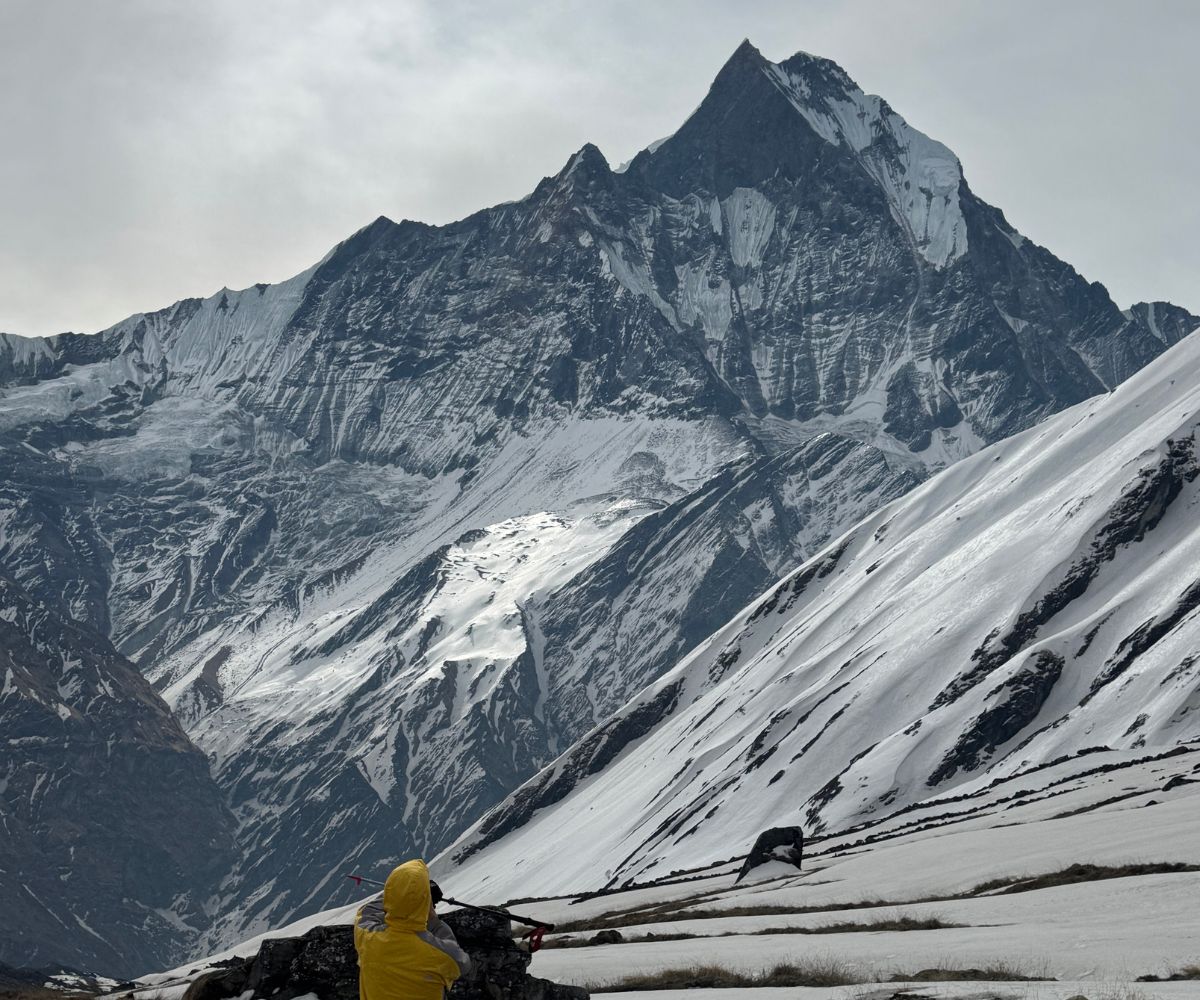
Poon Hill (3,210m) offers direct sunrise views of Annapurna I, Annapurna South, Machhapuchhre (Fishtail), and Dhaulagiri I. The single morning ascent from Ghorepani takes 1 hour and adds 400m of elevation. Almost all trekkers finishing through Ghorepani include Poon Hill, it adds only half a day but requires a small local entrance fee (typically NPR 100-300) at the viewpoint gate, which is charged separately from your Annapurna Conservation Area permit.
Does Route Direction Affect the Overall Plan?
Route direction, clockwise versus counterclockwise, changes daily stage difficulty but not total circuit distance. Clockwise remains the standard direction, accounting for approximately 90% of Annapurna Circuit trekkers, because it places the long Thorong La ascent from the gentler east side.
The clockwise direction climbs from Thorong Phedi (4,450m) or High Camp (4,850m) to the Thorong La (5,416m), gaining 566m to 966m on the ascent day, then descends 1,600m to Muktinath (3,800m). The counterclockwise direction reverses this, requiring a 1,600m climb from Muktinath before reaching the pass, a noticeably harder effort at altitude that guides and the HRA clinic consistently advise against for first-time high-altitude trekkers.
Which Route Sections Cover the Most Distance?
The lower Marsyangdi valley section between Besisahar and Manang covers approximately 110 km, making it the longest single segment of the circuit. The Thorong La crossing adds 20 km and the Kali Gandaki descent to Nayapul adds another 50 km. These 3 sections account for the circuit's full distance.
How Long Is the Lower Trail Before Manang?
The lower trail from Besisahar to Manang spans 110 km over 7 to 9 walking days, ascending from 760m to 3,519m through the villages of Bhulbhule, Jagat, Dharapani, Chame, Pisang, and Braga.
The Marsyangdi valley trail changes character 4 times across this section. The opening 2 days between Besisahar and Jagat walk through subtropical forest with rhododendron, sal trees, and occasional terraced rice paddies. Between Jagat and Chame, the valley narrows dramatically into a deep gorge with waterfalls and the trail gains 1,000m in 2 days. Above Chame, the valley opens onto the Paungda Danda rock face, a 1,500m sheer cliff wall, before reaching the ancient walled village of Pisang (3,185m). The final push to Manang crosses the transition into the arid rain shadow north of the Himalayas, where the landscape shifts from green forest to brown mountain steppe.
Much of the trail between Besisahar and Chame now runs alongside or directly on the jeep road, particularly between Bhulbhule and Dharapani. This section disappointed many trekkers who completed the circuit before the roads arrived and now return to find it significantly changed. Walking it remains possible but no longer essential.
How Demanding Is the Thorong La Crossing Day?
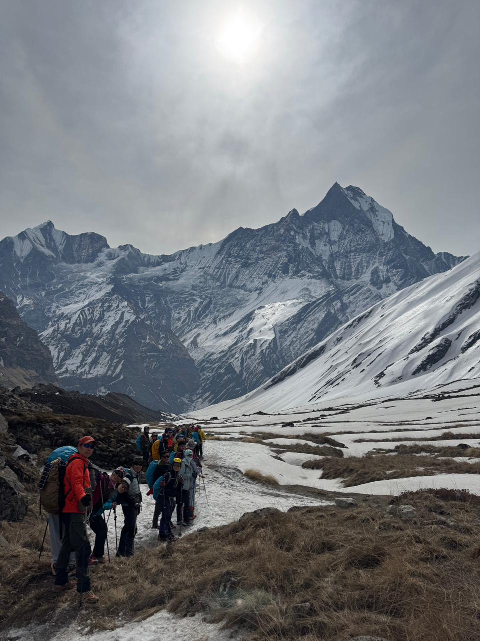
The Thorong La crossing day covers 20 to 22 km and gains 966m of elevation from Thorong Phedi (4,450m) to the pass at 5,416m, followed by a 1,600m descent to Muktinath (3,800m), the circuit's longest and most demanding single day.
Most trekkers leave from High Camp (4,850m) rather than Thorong Phedi, starting between 4:00 and 5:00 AM to reach the pass before afternoon winds develop. The ascent from High Camp to the pass covers 8 km over 4 to 5 hours. The descent from the pass to Muktinath covers 12 km over 3 to 4 hours.
The pass itself is marked by prayer flags and stone cairns at 5,416m. On a clear morning, views extend south across the Annapurna Himal, north toward the Mustang plateau, and east toward the Manaslu range. Temperatures at the pass drop to -10°C in October and below -20°C in winter. Wind chill makes effective temperatures much lower.
Altitude-related illness on crossing day remains the primary safety concern. Trekkers who feel AMS symptoms at High Camp, severe headache, nausea, loss of coordination, descend immediately rather than attempt the pass. The HRA reports 3 to 5 serious AMS incidents near the Thorong La each trekking season, most involving trekkers who did not complete their Manang acclimatization day.
What Distance Comes After Muktinath?
The trail from Muktinath to Nayapul covers approximately 70 to 80 km over 4 to 6 walking days, depending on whether the Ghorepani-Poon Hill detour is included.
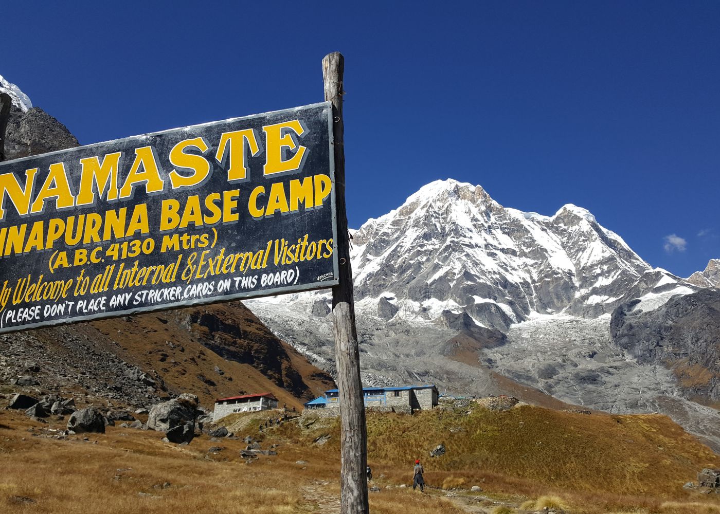
Muktinath (3,800m) is one of Nepal's most sacred Hindu and Buddhist pilgrimage sites, containing 108 water spouts and an eternal flame of natural gas that burns alongside running water. Below Muktinath, the trail descends through Kagbeni (2,810m), the last village open to trekkers before the restricted Upper Mustang plateau, and into the Kali Gandaki gorge.
The gorge section between Kagbeni and Tatopani covers approximately 45 km and walks alongside or above the Kali Gandaki River, the drainage between the Annapurna and Dhaulagiri massifs. Tatopani (1,190m) offers natural hot spring pools, one of the circuit's most-anticipated rest stops after weeks at altitude. From Tatopani, trekkers climb 1,400m to Ghorepani (2,860m) for the Poon Hill sunrise, then descend to Nayapul over 1 to 2 days.
Trekkers who fly from Jomsom skip the Kali Gandaki gorge, Tatopani, and Ghorepani entirely, ending their circuit at Jomsom's mountain airstrip (2,720m) with a 25-minute flight to Pokhara.
How Have Road Access and Trail Changes Affected the Circuit?
Motorable roads now parallel or replace trail on approximately 60 to 70 km of the Annapurna Circuit, primarily in the lower Marsyangdi valley between Besisahar and Chame and in the upper Kali Gandaki valley between Muktinath and Jomsom. These road sections arrived progressively between 2010 and 2020 and fundamentally altered the experience of the circuit's lower elevations.
Which Sections Do Trekkers Commonly Skip Now?
The 3 sections trekkers most commonly skip by jeep or flight are the Besisahar-to-Chame lower valley (55 km), the Muktinath-to-Jomsom road section (20 km), and the Jomsom-to-Nayapul trail (50 km) replaced by a Jomsom-to-Pokhara flight.
The Besisahar-to-Chame section receives the most skips. The jeep road between these towns is heavily used, dusty in dry season, and passes through villages that have reorganized around road transport rather than trekking hospitality. Trekking it on foot remains possible and cheaper, but the experience is substantively different from what this section offered before 2012.
The Muktinath-to-Jomsom section is a 20 km descent that now largely follows a jeep track. Trekkers on tight schedules drive this section in under 1 hour rather than walk it in 5 to 6 hours. What's lost is the dramatic view of the Kali Gandaki's upper gorge and the apple orchards of Marpha village (2,670m), which produces Nepal's best apple brandy.
What Is the Road-Free Trail Option on the Circuit?
The Annapurna Circuit's road-free trail option follows the upper Pisang to Manang high route (3,500m to 4,000m elevation), bypassing the lower valley road and adding approximately 5 km compared to the road-level trail but eliminating road walking between Pisang and Humde.
This high route runs from Upper Pisang (3,300m) through Ghyaru and Ngawal to Manang, traversing a ridge with unobstructed views of the Annapurna II, III, and IV massif to the south. The villages on this route remain completely road-free and retain the traditional stone architecture and farming lifestyle that lower-circuit villages lost when the road arrived.
Above Manang, the trail to High Camp and the Thorong La remains entirely road-free on both sides of the pass. The Ghorepani-Poon Hill section on the southern descent is also road-free, making it consistently the most praised section of the lower circuit. If limited days force a choice between which sections to walk and which to skip by vehicle, prioritize the upper circuit from Chame onward plus the Ghorepani finish.
How Difficult Is the Annapurna Circuit Because of Its Length?
The Annapurna Circuit rates as a moderate-to-strenuous trek because of its length combined with altitude, not because of technical terrain. The trail requires no ropes, crampons, or technical climbing skills. The challenge comes from daily distances averaging 15 to 22 km, cumulative elevation gain of approximately 7,000m, and sustained time at altitude between 3,000m and 5,416m over 14 to 18 days.
Do Altitude and Elevation Matter More Than Distance?
Altitude affects performance more than flat-distance figures suggest on the Annapurna Circuit. At 4,500m, the effective oxygen level is approximately 57% of sea-level concentration. This means a 10 km walk at High Camp takes 40% longer and requires substantially more effort than the same distance at the circuit's starting elevation.
The cumulative elevation gain on the full circuit, approximately 7,000m up and 7,000m down, exceeds what most trekking routes in the Alps or Rockies demand over the same number of days. Daily vertical gain on heavy ascent days reaches 1,200m, equivalent to climbing 400 floors of stairs at altitude.
Trekkers who focus only on daily kilometer counts and ignore elevation profiles regularly misjudge their itinerary. A 22 km crossing day over the Thorong La is not comparable to a 22 km flat trail day. Planning daily stages by both distance and elevation gain together produces more accurate time estimates.
How Many Hours a Day Do Most Trekkers Walk?
Most Annapurna Circuit trekkers walk 5 to 8 hours per day, covering 12 to 22 km depending on terrain and altitude. Shorter walking days tend to occur above 4,000m, where altitude slows pace to 2 to 3 km per hour even on experienced trekkers. Longer walking days occur in the lower valley where altitude does not limit speed.
The Thorong La crossing day is the exception: 8 to 10 hours of total walking from High Camp through the pass to Muktinath. This single day demands more time than any other stage and typically consumes full daylight.
Rest-day use in villages like Manang, Tatopani, and Ghorepani reduces average daily hours but increases total itinerary days. Trekkers who maintain 6 to 7 daily walking hours consistently finish the circuit in 14 days. Those who average 4 to 5 hours per day find 18 to 21 days more comfortable. Neither pace is wrong, daily walking time is the most reliable single variable for estimating total circuit duration.
How Should You Choose the Right Annapurna Circuit Itinerary?
Choose your Annapurna Circuit itinerary by matching available days to fitness level, altitude experience, and which sections matter most to you. The 3 itinerary types, short, standard, and extended, each suit a different trekker profile.
Is a Short, Standard, or Extended Route Best for You?
First-time high-altitude trekkers consistently benefit from choosing the standard or extended itinerary over the short version. The extra days near 3,500m to 4,000m build acclimatization and reduce Thorong La crossing risk.
-
A 10 to 12 day short route suits fit trekkers with previous high-altitude experience and limited vacation days. It uses jeep transport from Besisahar to Chame, walks the upper circuit in full, and returns by flight from Jomsom. The core mountain experience, Pisang to Muktinath, is completely intact.
-
A 14 to 18 day standard route suits the majority of trekkers: those with moderate fitness, no specific altitude experience requirement, and adequate time. It walks the full circuit from Chame or Besisahar to Nayapul, includes the Poon Hill detour, and builds in 1 to 2 acclimatization days at Manang.
-
A 21 to 28 day extended route suits trekkers prioritizing complete immersion, side trips, and flexibility. It includes Tilicho Lake, the Pisang high route, Poon Hill, and buffer days at multiple villages. Trekkers who have done the standard circuit and return often choose this version to cover what they missed on their first time.
When Is It Worth Adding Popular Side Trips?
Add Tilicho Lake to your itinerary when you have 2 additional days at Manang, strong acclimatization, and a tolerance for exposed high-altitude trails. At 4,919m, Tilicho Lake occupies a glacial bowl beneath the Tilicho Peak (7,134m) north face. The approach crosses a scree slope with active rockfall, making the side trip genuinely hazardous in wet or windy conditions, not merely strenuous.
Add the Poon Hill sunrise whenever your descent route passes through Ghorepani. The detour adds only half a day and requires just a small local viewpoint fee (NPR 100-300) on top of your standard Annapurna Conservation Area permit. Of all the circuit's side trips, Poon Hill delivers the highest visual reward for the smallest time investment, 400m of ascent for a spectacular panorama spanning two eight-thousanders (Annapurna I and Dhaulagiri) alongside dramatic peaks like Machhapuchhre and Annapurna South.
Skip the Khopra Danda extension unless you have 3 extra days and prior multi-day high-altitude ridge experience. This trail runs from Ghorepani south along the Annapurna South ridge to a high camp at 3,660m, far from any medical facility.
How Can a Trekking Guide Help You Plan the Right Route Length?
A licensed Annapurna Circuit trekking guide reduces route-planning errors by providing current trail conditions, accurate daily stage times based on your pace assessment, and real-time acclimatization monitoring throughout the trek. Guides registered with the Nepal Tourism Board (NTB) and the Trekking Agencies' Association of Nepal (TAAN) carry legally required first aid training, altitude sickness protocols, and satellite communication devices.
Independent trekking on the Annapurna Circuit is no longer legal for foreign nationals; since April 2023, the Nepal Tourism Board requires all trekkers to hire a licensed guide through a registered agency. However, guides prevent the 3 most common planning failures: choosing an itinerary too short for one's fitness level, skipping the Manang acclimatization day under schedule pressure, and underestimating post-Thorong La distances in the Kali Gandaki section.
Can a Trekking Agency Match the Route to Your Fitness?
A trekking agency matches routes to fitness through a structured pre-trek consultation covering 4 factors: previous trekking altitude, daily walking endurance, total available days, and physical condition assessment. Reputable agencies in Kathmandu and Pokhara offer personalized itineraries rather than fixed departures, allowing stage-by-stage customization.
The practical benefit appears on the most demanding days. A guide who assessed your pace in the lower valley arrives at High Camp knowing whether to push for the pass crossing at 4:00 AM or schedule an extra night to allow more acclimatization. That single decision difference determines whether you summit the pass or turn back with altitude sickness.
Agencies also provide up-to-date information on road closures, seasonal trail conditions, and teahouse availability, details that change between trekking seasons and are not reliably reflected in any published guidebook or online resource. The Annapurna Conservation Area fee (NPR 3,000 per person) and TIMS card (NPR 2,000 per person) remain mandatory, but note that TIMS cards are now exclusively issued through your trekking agency rather than to individuals.
What Are the Key Takeaways About the Circuit's Length?
The Annapurna Circuit covers 160 to 230 km of trekking trail and takes 10 to 21 days to complete. The exact distance and duration you experience depends on 4 decisions: where you start walking, which sections you cover by vehicle or flight, how many side trips you add, and how many acclimatization rest days you take.
The circuit's length is not its main challenge. Altitude is. The Thorong La Pass at 5,416m stands as the route's physical threshold, and the acclimatization days in Manang determine whether you cross it safely or turn back. Every extra day you build into your itinerary between 3,500m and 4,500m pays dividends on crossing day.
The lower Marsyangdi valley has changed significantly since 2012 because of road construction, but the upper circuit, from Chame through the Thorong La to Muktinath, and the Ghorepani-Poon Hill finish remain as rewarding as they have always been.
A 14 to 16 day standard itinerary walking from Besisahar to Nayapul with 1 acclimatization day in Manang and the Poon Hill detour represents the best balance of distance, safety, and experience for the majority of trekkers. If your schedule allows 18 or more days, add Tilicho Lake without hesitation. If you have only 10 days, start from Chame, walk every trail meter from there, and fly from Jomsom. Either version is the Annapurna Circuit.
