The Annapurna Base Camp Trek is a Himalayan journey defined by the extraordinary concentration of mountain scenery, changing landscapes, and cultural experiences along a relatively short trekking route. The trail rises from the subtropical valleys and terraced farmland around Pokhara through rhododendron, oak, and bamboo forests, Gurung and Magar villages, alpine terrain, and finally the glacial landscape of the Annapurna Sanctuary at 4,130 meters. The scenery becomes increasingly dramatic as Annapurna I (8,091m), Annapurna South, Annapurna III, Gangapurna, Hiunchuli, and Machhapuchhre emerge around the route, culminating in a natural amphitheater where towering Himalayan peaks, glaciers, ice ridges, and moraine surround Annapurna Base Camp. Rivers, waterfalls, Himalayan wildlife, rhododendron blooms, traditional stone villages, prayer flags, and the hot springs at Jhinu Danda add layers of natural and cultural beauty beyond the main mountain panorama.
.avif)
The beauty of the Annapurna Base Camp Trek also changes with elevation, weather, season, light, and local culture, giving the route a different character throughout the year. Spring transforms the forests with red, pink, and white rhododendrons, autumn provides crisp mountain visibility and blue skies, winter creates snow-covered peaks and quieter trails, while monsoon produces intensely green valleys, swollen rivers, and waterfalls. Sunrise at Annapurna Base Camp, the changing vegetation between Chhomrong and Machhapuchhre Base Camp, views from Ghandruk and Chhomrong, and the enclosed panorama of the Annapurna Sanctuary each reveal a different aspect of the trek's scenery. This guide explores the mountains, forests, rivers, waterfalls, wildlife, seasonal landscapes, traditional villages, Gurung and Magar culture, viewpoints, and responsible ways to experience them, explaining what makes the Annapurna Base Camp Trek one of Nepal's most visually diverse and immersive Himalayan trekking experiences.
Why Is the Annapurna Base Camp Trek Famous for Its Natural Beauty?
The Annapurna Base Camp Trek is famous for its natural beauty because it delivers close-range views of 8,000-meter peaks, five climate zones within roughly 40 kilometers of walking distance, and a glacial amphitheater that no other moderate trek in Nepal replicates. Most Himalayan routes offer one dominant landscape type. The Annapurna Base Camp Trek compresses jungle, forest, alpine meadow, and glacier into a single week, and it does this while keeping the trail accessible to trekkers without mountaineering experience.
What Makes the Annapurna Mountain Views So Spectacular?
Annapurna Base Camp places trekkers inside a ring of peaks rather than across a valley from them. Annapurna I rises to 8,091 meters directly above the base camp, close enough that no zoom lens is required to see its ice ridges. A French expedition led by Maurice Herzog summited Annapurna I in 1950, making it the first 8,000-meter peak ever climbed, three years before Everest. That first ascent still anchors the mountain's reputation among mountaineers and gives trekkers a tangible historical reference point while standing at its base. The surrounding wall of Annapurna South, Hiunchuli, Gangapurna, and Annapurna III completes a 360-degree amphitheater rarely matched at this altitude without technical climbing gear.
Trekkers comparing this trek to Everest Base Camp often expect a similar experience at a lower altitude, but the two views work differently. Everest Base Camp sits at 5,364 meters and looks across the Khumbu Icefall toward peaks still several kilometers distant, with Everest itself partly hidden behind Nuptse. Annapurna Base Camp, at 4,130 meters, sits inside the ring of peaks rather than facing it from outside, which is why photographs from the Sanctuary show mountains on nearly every side rather than a single dominant summit. A common mistake among first-time trekkers is underestimating altitude risk here simply because the number looks lower than Everest Base Camp; 4,130 meters still carries a genuine risk of acute mountain sickness, and the standard precaution remains the same: ascend gradually and treat headaches or nausea as a signal to stop climbing rather than push through.
Which Landscapes Can You Experience Along the Trek?
Trekkers pass through five landscapes on the Annapurna Base Camp Trek: subtropical forest, temperate rhododendron forest, bamboo and oak forest, alpine scrub, and glacial moraine. Each zone changes the trail's temperature, vegetation, and light within a single day of walking. Rice terraces and banana groves mark the lower subtropical belt near Pokhara, between roughly 1,000 and 1,700 meters. Rhododendron and oak dominate the mid hills around Chhomrong, from about 1,700 to 2,500 meters. Bamboo thickets close in above Sinuwa, from roughly 2,300 to 3,000 meters. Alpine scrub opens the view near Machhapuchhre Base Camp, above 3,000 meters. Bare rock and glacier ice surround the final approach to Annapurna Base Camp itself, above 3,700 meters.
Each zone also supports different wildlife, which adds a layer of natural beauty beyond the plants and peaks. Himalayan langur monkeys move through the forest belt around Sinuwa and Bamboo. Himalayan tahr, a wild goat species, graze the alpine scrub near Machhapuchhre Base Camp. The danphe, Nepal's national bird and also known as the Himalayan monal, appears at higher elevations within the conservation area, identifiable by iridescent plumage that shifts color depending on the light, a detail many trekkers miss because they are looking up at the mountains rather than down at the ridgeline scrub.
How Does the Annapurna Sanctuary Enhance the Trekking Experience?
The Annapurna Sanctuary is the glacial basin at the trek's end, enclosed by a ring of peaks and entered through a narrow gorge between Machhapuchhre and Hiunchuli. Local Gurung communities consider the Sanctuary sacred ground and historically restricted certain foods, including meat and eggs, from being carried past specific points on the trail out of respect for the deities believed to inhabit it. That gorge entrance creates a dramatic shift in scenery: trekkers walk through a shadowed, narrow passage and emerge into an open glacial bowl ringed by seven major peaks. Few treks anywhere deliver that kind of staged visual reveal at the finish line.
What Natural Highlights Can You See on the Annapurna Base Camp Trek?
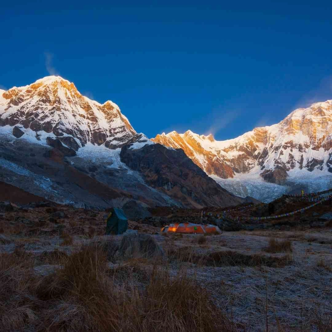
The Annapurna Base Camp Trek's core natural highlights are its 8,000-meter and 7,000-meter mountain panoramas, its rhododendron forests, and its rivers, waterfalls, and hot springs. Each highlight appears at a different point on the route, which spreads the visual reward across the entire itinerary instead of concentrating it at the final destination.
Which Mountains Can You See From Annapurna Base Camp?
Annapurna Base Camp offers direct views of six major peaks: Annapurna I (8,091m), Annapurna South (7,219m), Annapurna III (7,555m), Gangapurna (7,455m), Hiunchuli (6,441m), and Machhapuchhre (6,993m). Annapurna I dominates the northern skyline, while Machhapuchhre's distinctive fishtail summit marks the Sanctuary's southern edge. Machhapuchhre remains legally unclimbed. A 1957 British expedition led by Jimmy Roberts turned back a few meters short of the summit, honoring a promise to local communities who consider the peak sacred, and no climbing permits have been issued for it since.
Positioning matters as much as height when judging these views. Annapurna I sits to the north of the base camp and catches direct morning light first, which is why sunrise photographs typically show it glowing gold while Annapurna South, to the west, remains in shadow a few minutes longer. Trekkers photographing the full panorama in one frame generally find the widest unobstructed angle a short walk beyond the main base camp lodges, past the memorial plaques for climbers who died on Annapurna I, an important reminder that this is still one of the most technically demanding 8,000-meter peaks to summit despite its accessible base camp.
How Beautiful Are the Rhododendron Forests on the Trek?
The Annapurna Conservation Area holds roughly 30 species of rhododendron, Nepal's national flower, concentrated around Ghorepani, Tadapani, and the ridge between Chhomrong and Sinuwa. Flowering timing shifts with elevation rather than a single calendar date. Lower forests around 2,000 meters bloom first, and the color line climbs the mountainside as the weeks pass, so trekkers moving upward during the season can walk through blooming forest more than once on the same trip. Red and pink varieties dominate the lower belts, while white and pale pink species appear at higher elevation.
What Makes the Waterfalls, Rivers, and Hot Springs Scenic?
The Modi Khola, a glacier-fed river, runs the length of the Annapurna Sanctuary and feeds seasonal waterfalls near Chhomrong and Sinuwa that are visible directly from the trail. At Jhinu Danda, roughly 1,780 meters and a short descent from Chhomrong, natural hot springs sit beside the Modi Khola itself. Trekkers commonly build in a rest afternoon here, since the springs sit low enough to reach without an overnight detour and offer genuine muscle recovery after the steep stone staircases lower on the route.
What most itineraries overlook is timing: the springs sit in a river-level gorge that loses direct sunlight by mid-afternoon in autumn and winter, so trekkers arriving after 2:00 PM often find the pools already in shade and considerably colder. Arriving before midday, particularly on the descent rather than the ascent, gives the warmest water and the clearest light for photographing the river gorge itself, which narrows sharply just downstream of the springs and produces small, fast rapids worth the short extra walk.
How Does the Changing Landscape Add to the Trek's Beauty?
The Annapurna Base Camp Trek's beauty comes from constant landscape change rather than a single dramatic peak view, since the trail shifts through five distinct ecological zones over four to five days of walking. Treks confined to one biome, however scenic, cannot replicate that variety.
How Does the Scenery Change Along the Annapurna Base Camp Route?
Scenery on the Annapurna Base Camp route changes in four clear stages: subtropical valley from Pokhara to Chhomrong, dense forest above Chhomrong, alpine scrub near Machhapuchhre Base Camp, and glacial terrain at Annapurna Base Camp. Each stage has its own defining features, detailed below.
What Is the Landscape Like From Pokhara to Chhomrong?
The route from Pokhara to Chhomrong opens with terraced rice fields and subtropical forest around Nayapul and Birethanti. Trekkers cross the Modi Khola on suspension bridges strung above the river gorge and pass through Gurung and Magar villages including Tikhedhunga and Ulleri. The climb from Tikhedhunga to Ulleri covers more than 3,000 stone steps, a stretch locally known for testing new trekkers before the trail rewards them with the first clear views of Annapurna South and Hiunchuli.
What Makes the Forest Trails Above Chhomrong Beautiful?
Above Chhomrong, the trail drops steeply to the Chhomrong Khola before climbing through Sinuwa, Bamboo, and Dovan. Dense bamboo thickets close in around the path, mixed with rhododendron and oak, and the forest canopy blocks direct sun for much of the day. Himalayan langur monkeys move through this stretch regularly, and the humid, green corridor contrasts sharply with the open mountain views that follow it.
How Does the Landscape Change Near Machhapuchhre Base Camp?
Near Machhapuchhre Base Camp, at roughly 3,700 meters, the forest thins into alpine scrub and open grassland. Waterfalls become visible on the surrounding cliff faces, and Hiunchuli and Annapurna South appear close enough to feel immediate rather than distant. This section also marks an avalanche-prone zone below Hiunchuli, and guided groups typically move through it without lingering, which adds a layer of raw, exposed drama to the scenery that the lower forest sections lack.
What Makes Annapurna Base Camp a Stunning Final Destination?
Annapurna Base Camp sits at 4,130 meters inside a glacial amphitheater ringed by Annapurna I, Annapurna South, Annapurna III, Gangapurna, and Machhapuchhre. Bare rock, glacier ice, and moraine replace vegetation entirely at this elevation. Sunrise here lights the peaks in sequence, moving from pink to gold as the sun clears the ridgeline, and the enclosed shape of the basin means every direction offers a mountain view rather than a single vantage point.
When Is the Annapurna Base Camp Trek Most Beautiful?
The Annapurna Base Camp Trek looks distinctly different across its four seasons: spring brings rhododendron blooms, autumn brings the clearest mountain visibility, winter brings snow-draped stillness, and monsoon brings intense green valleys. No single season claims exclusive ownership of the trek's beauty; each rewards a different priority.
What Makes Spring Ideal for Seeing Rhododendron Blooms?
Spring, running from March through May, turns the mid-altitude forests red, pink, and white as rhododendron trees bloom in sequence up the mountainside. Daytime temperatures stay moderate on the lower and middle sections of the trail, and mornings typically offer the clearest skies before afternoon haze builds. Trekkers prioritizing forest color and comfortable walking temperatures over maximum mountain clarity find spring the strongest match.
Daytime temperatures at lower elevations typically reach 15°C to 20°C, dropping to near freezing overnight at Annapurna Base Camp itself. Late March through mid-April marks the peak bloom window for the lower rhododendron belt around Ghorepani and Tadapani, while forests above 2,500 meters near Chhomrong and Sinuwa often bloom two to three weeks later, into early May. Trekkers timing a trip purely around flowers benefit from checking which elevation band is blooming that week rather than fixing a date months in advance, since the bloom line moves at a pace weather can shift by several days in either direction.
How Does Autumn Enhance Mountain Views?
Autumn, from September through November, follows the monsoon and delivers the most stable weather and the clearest air of the year. Peaks appear sharply defined against consistently blue skies, with minimal cloud buildup even in the afternoon. This clarity, combined with comfortable daytime temperatures, makes autumn the busiest season on the trail, and trekkers prioritizing unobstructed mountain photography over solitude generally choose this window.
Daytime temperatures at lower elevations stay in the 15°C to 20°C range through October, cooling toward 5°C to 10°C by November, with overnight lows at Annapurna Base Camp regularly falling below freezing. The trade-off for autumn's reliable skies is teahouse capacity: rooms at Chhomrong, Machhapuchhre Base Camp, and Annapurna Base Camp fill quickly during the October and early November peak, and trekkers arriving without pre-arranged accommodation sometimes find themselves walking further than planned to secure a bed. Booking teahouses a day ahead through a guide, or starting each day's walk early enough to reach the next stop by early afternoon, avoids this issue.
What Can You Expect From the Scenery During Winter?
Winter, from December through February, covers Machhapuchhre Base Camp and Annapurna Base Camp in snow and drops overnight temperatures at those elevations to between -15°C and -20°C. Air remains dry and exceptionally clear, often producing the sharpest long-distance mountain visibility of the year, while trail traffic drops significantly. Trekkers prepared for cold-weather gear and shorter daylight hours gain near-empty trails and stark, snow-covered panoramas in exchange.
Snowfall above Deurali can occasionally close the final stretch to Annapurna Base Camp for a day or two after a heavy storm, and trekkers should build a spare day into a winter itinerary to absorb that possibility rather than treating the schedule as fixed. Many teahouses above Chhomrong reduce their opening hours or close entirely in January, the coldest month, so confirming lodge availability before departure matters more in winter than in any other season. The reward for this extra planning is a version of the Sanctuary few trekkers see: fresh snow on the peaks, empty trails, and mountain silhouettes rendered in sharper contrast against winter's drier, thinner air.
How Does the Monsoon Change the Landscape?
Monsoon, from June through August, saturates the lower and mid-altitude forests, turning terraced hillsides and jungle sections a deep, saturated green and swelling the Modi Khola and its waterfalls to their fullest volume. Cloud cover regularly obscures high peaks, rain increases landslide risk on exposed sections, and leeches become common in the forest zones. Trails empty out almost entirely during this period, which suits trekkers focused on lush valley scenery and solitude over guaranteed mountain visibility.
What Cultural Beauty Can You Experience on the Annapurna Base Camp Trek?
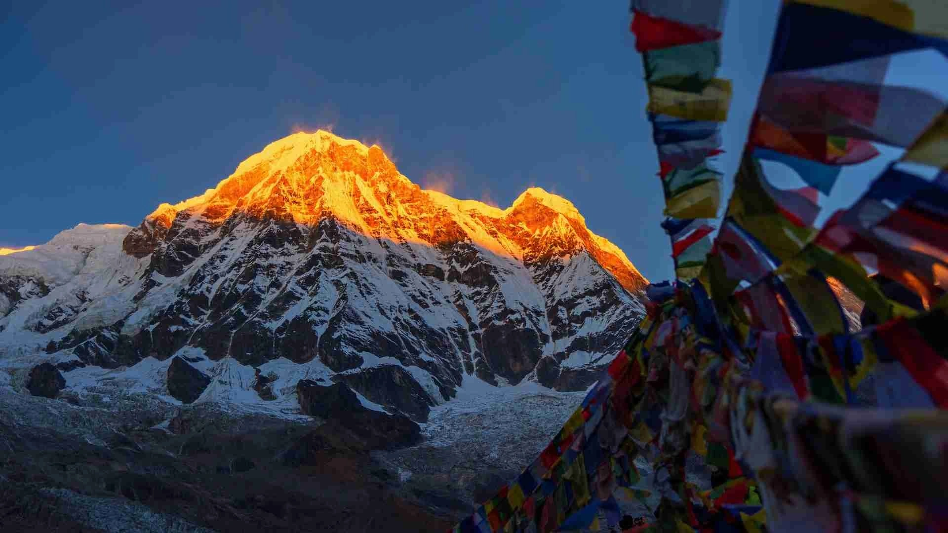
Cultural beauty on the Annapurna Base Camp Trek comes from Gurung and Magar villages set directly into the mountain scenery, adding a lived-in human layer to the natural landscape. Stone houses, terraced fields, and prayer flags appear throughout the lower and middle sections of the route, framed against the same peaks trekkers came to see.
Which Gurung and Magar Villages Can You Explore?
Ghandruk, Chhomrong, Landruk, and Tolka are the trek's main Gurung villages, while Birethanti, Tikhedhunga, and Hile represent its predominantly Magar and mixed communities. Ghandruk sits at roughly 1,940 meters with unobstructed views of Annapurna South and Machhapuchhre directly from its stone courtyards. Chhomrong, the last major village before the trail enters forest terrain proper, functions as both a cultural stop and the last point to buy trekking supplies before the higher, more remote sections.
The Gurung community traces its presence in this region back several centuries and speaks Tamu Kyui alongside Nepali, maintaining a distinct oral history and religious practice that blends Tibetan Buddhism with older animist traditions. Gurung men have served in Gurkha regiments of the British and Indian armies since 1815, a history that shaped village architecture and economy, since remittances from military service funded many of the stone houses and schools visible along the trail today. Magar villages lower on the route follow a related but separate cultural tradition, with their own language and dress, and Magar communities represent one of Nepal's largest indigenous groups nationally, not a minority specific to this valley.
How Do Traditional Villages Add to the Trek's Charm?
Stone-paved paths, slate-roofed houses, and terraced barley and millet fields define the architecture of villages along the lower route. Prayer flags strung between rooftops and mani walls at village entrances mark the Buddhist and animist traditions practiced alongside Hindu customs in the region. These structures sit directly beneath the mountains, so trekkers photograph traditional rooftops with Annapurna South or Machhapuchhre rising immediately behind them, a combination the higher, uninhabited sections of the trail cannot offer.
What Cultural Experiences Complement the Mountain Scenery?
Ghandruk houses a dedicated Gurung Museum documenting local dress, farming tools, and the community's long history supplying soldiers to Gurkha regiments. Small Buddhist gompas appear in several villages along the route, and teahouses throughout the trek serve dal bhat, the staple rice and lentil meal, alongside regional dishes like gundruk, a fermented leafy green. These experiences give trekkers a reason to slow down in villages rather than treating them purely as overnight stops between mountain views.
Trekkers passing through in mid-winter sometimes coincide with Lhosar, the Gurung and Tamang new year celebration, marked with traditional dance, music, and dress in villages including Ghandruk and Chhomrong. Traditional Gurung dress, worn during festivals and increasingly for cultural performances arranged for visitors, includes the ghalek, a wrapped skirt, paired with distinctive jewelry passed down through generations. None of this requires a special detour; it happens in the same villages the trekking route already passes through, which is what separates the Annapurna Base Camp Trek's cultural layer from treks where villages exist only as functional rest stops.
How Can You Best Experience the Beauty of Annapurna Base Camp Trek?
The best way to experience the beauty of the Annapurna Base Camp Trek combines well-timed viewpoints, responsible photography practices, and a route plan built around light and weather rather than distance alone. Trekkers who plan around sunrise timing and viewpoint selection consistently report clearer, more memorable mountain views than those who treat the trek as a fixed daily mileage target.
Which Viewpoints Offer the Best Mountain Scenery?
Annapurna Base Camp itself offers the trek's best sunrise viewpoint, with Machhapuchhre Base Camp and Chhomrong ranking as strong secondary options. At Annapurna Base Camp, the enclosed amphitheater shape means sunrise lights peaks on all sides in sequence. Machhapuchhre Base Camp offers a similar but slightly more distant panorama with less crowding at dawn. Chhomrong, lower on the route, gives trekkers their first unobstructed view of Annapurna South and Machhapuchhre together, framed above the village rooftops.
Reaching Annapurna Base Camp for sunrise generally means leaving Machhapuchhre Base Camp before 5:00 AM, since the walk between the two takes roughly two hours and the light show over the peaks begins shortly after 6:00 AM depending on the season. Trekkers extending their itinerary with a side trip to Poon Hill, at 3,210 meters near Ghorepani, gain a wider western panorama that includes Dhaulagiri alongside the Annapurna range, a genuinely different composition from the enclosed Sanctuary view. Mardi Himal, a separate viewpoint trek reaching roughly 4,500 meters, offers a quieter alternative for trekkers who want a comparable panorama with a fraction of the foot traffic, though it requires a different trailhead and cannot be combined with the main Annapurna Base Camp route in a single day.
How Can You Capture the Trek's Natural Beauty Responsibly?
Drone use inside the Annapurna Conservation Area requires a separate permit and remains restricted near wildlife and village areas, so trekkers should confirm rules before flying one. Staying on marked trails prevents damage to fragile alpine vegetation that takes years to recover once trampled. Respecting local custom around the Sanctuary, including avoiding meat and eggs on the final stretch where communities request it, preserves the same cultural relationship with the landscape that gives the Sanctuary its meaning. Most teahouses along the route now offer safe drinking water refill stations, and using a reusable bottle instead of buying bottled water reduces the plastic waste that otherwise accumulates on the trail.
The Annapurna Conservation Area Permit itself supports this preservation work directly. It costs NPR 3,000, roughly USD 23, for foreign nationals, alongside a TIMS card priced at NPR 2,000, roughly USD 17, and both are checked at multiple points along the route, including Birethanti and Chhomrong. Managed by the National Trust for Nature Conservation, the ACAP fee funds trail maintenance, reforestation, and the community-based conservation programs that keep the rhododendron forests and wildlife corridors intact. Paying for these permits, rather than treating them as a bureaucratic formality, is itself part of preserving the scenery the trek is famous for.
Can Nepal Intrepid Treks Help You Experience the Beauty of Annapurna Base Camp?
Nepal Intrepid Treks, a Kathmandu-based trekking operator, arranges guided Annapurna Base Camp itineraries with licensed guides, a legal requirement for foreign trekkers in the Annapurna region since April 2023, as well as optional porters. The company handles ACAP and TIMS permit paperwork ahead of the trek, organizes teahouse-based accommodation along the route, and structures daily walking distances around acclimatization and viewpoint timing rather than fixed mileage alone. Trekkers weighing a self-arranged trip against a guided one gain, through this kind of support, more consistent access to sunrise viewpoints and less time spent on logistics that a first-time visitor to the region would otherwise need to manage alone. Licensed guides also carry practical knowledge that shapes the visual experience directly: which teahouse balcony faces Annapurna South at sunrise, when a side trail to a waterfall is worth the extra thirty minutes, and how to adjust a day's start time around cloud patterns that build predictably by early afternoon in most seasons.
What Are the Key Takeaways About the Beauty of Annapurna Base Camp Trek?
The Annapurna Base Camp Trek delivers close-range views of Annapurna I and five other major peaks, five distinct ecological zones within a single route, a sacred glacial Sanctuary at its end, and living Gurung and Magar culture throughout its lower villages. Spring rewards rhododendron color, autumn rewards mountain clarity, winter rewards solitude and snow-covered stillness, and monsoon rewards lush, quiet valleys, so the right season depends on which version of the trek's beauty matters most to a given trekker. As independent trekking is no longer permitted for foreign nationals, walking with your mandated guide through an outfitter like Nepal Intrepid Treks ensures the core reward stays the same: a single trail that moves from rice terraces to glacier in under a week, with a sacred mountain amphitheater waiting at the end of it.
Choosing a season comes down to one question worth answering honestly before booking: is the priority forest color, mountain clarity, solitude, or valley greenery. That answer, more than any fixed calendar date, should decide the trip's timing. Everything else, from the licensed guide requirement to the ACAP and TIMS permits, from the villages along the lower route to the glacial basin at the top, stays consistent year-round and simply looks different depending on when a trekker chooses to walk through it.

.avif&w=1920&q=75)